
Deformation Band Delivers Over-Performing Snowfall Across the Twin Cities, Dropping 5 to 8+ Inches in 24 Hours
Published: February 19, 2026.
TWIN CITIES, MINNESOTA - What began as a forecast calling for a modest 2 to 4 inches of snowfall turned into a much more impactful winter event across the Twin Cities metro, as a powerful deformation band parked itself over the region on Wednesday and persisted into early Thursday morning.
By sunrise Thursday, many communities had measured between 5 and 8 inches of snow, nearly double the higher-end forecast totals in some locations, after snowfall rates proved strong enough to overcome initially warm ground temperatures.
A Stubborn Snow Band
As a surface low spun over central Minnesota around noon on Wednesday, a pronounced deformation band - which is a narrow zone within a winter storm where the air is being stretched and wrapped around the center of low pressure, causing snow to fall heavier and longer in one specific area - stretched from central North Dakota into south-central Minnesota.
Within this deformation zone, there was moderate to heavy, steady snowfall developing under the band, with winds gusting over 40 mph at times and widespread visibility dropping to one-quarter mile or less in parts of southwest Minnesota. This resulted in whiteout conditions, particularly near the Minnesota River Valley, where blizzard warnings were issued.
Around noon, the NWS in the Twin Cities reported they had measured only 0.4 inches of snowfall, with 0.05 inches of liquid equivalent. However, forecasters cautioned that accumulation was limited early on due to warm surface temperatures and melting occurring on roadways and other surfaces. These warm surface temperatures were one of the factors contributing to uncertainty on high-end snow totals for this event. There was also uncertainty in the model guidance about exactly where the heaviest snow band would settle, another critical factor that ultimately determined who saw the highest totals.
Snowfall Rates Overcome Warm Ground
Despite early concerns about melting, snowfall intensity increased in the afternoon and evening. Under a persistent deformation band, moderate to occasionally heavy snow fell for several hours. In many areas, snowfall rates were sufficient to cool surface temperatures and accelerate accumulation. Once the snowpack began to establish, accumulation efficiency improved significantly.
The result: totals far exceeded the cautious 2–4 inch forecast in many metro communities.
Remnant Band Lingers Into Thursday Morning
By early Thursday morning, a remnant band of light snow remained draped across the Twin Cities region. This lingering band produced lighter, fluffier snow accumulations, adding a final layer to the already substantial totals. While winds diminished compared to Wednesday afternoon’s peak gusts, untreated roads remained snow-covered and slick during the morning commute.
24-Hour Snowfall Totals (As of Thursday Morning)
Here are selected snowfall reports from across the metro:
Savage - 6.8” to 7.0”
Excelsior – 6.3"
Chanhassen – 6.5” to 7.5"
Richfield – 7.6"
Burnsville - 6.5”
Apple Valley - 4” to 5.7”
West St. Paul – 5.5"
Golden Valley – 5.5"
Prior Lake - 8.8”
Shorewood - 8.5”
Bloomington – 8.1"
Waconia – 7.7"
MSP Airport – 7.6"
Edina – 7.5"
Elko New Market – 7"
Eagan – 7"
The highest totals clustered across the southwest and south metro, consistent with where the deformation band ultimately stalled for several hours.
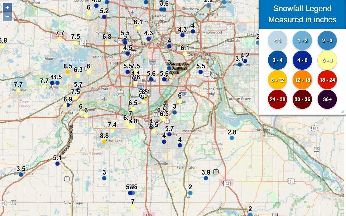
Provided by the NWS Twin Cities.
Why This System Over-Performed
Several factors contributed to the higher-than-expected snowfall:
Band Placement: The deformation band shifted slightly northward compared to some model guidance, placing the Twin Cities under prolonged moderate to, at times, heavy snow.
Snowfall Rates: Intense snowfall rates cooled the boundary layer quickly, overcoming warm ground temperatures.
Duration: The band “parked” over the region longer than anticipated.
Late-Night Fluffy Additions: The remnant band early Thursday added lighter, more efficient accumulation.
This event highlights the forecasting challenges associated with narrow deformation bands. Small shifts of 20–30 miles can dramatically alter who sees 2 inches versus 8 inches.
Travel Impacts: Roads Deteriorated Quickly as Ice Formed Beneath Snow
While blowing snow caused visibility issues at times, one of the more significant impacts across the southern Twin Cities metro was the rapid deterioration of road conditions on Wednesday afternoon. As snowfall rates intensified within the deformation band, the heavier bursts of snow quickly cooled pavement temperatures. That rapid cooling allowed a thin layer of ice to form at the surface. Snow then accumulated on top of that icy layer and was compacted by traffic, creating extremely slick driving conditions in a short time.
Drivers reported that roads transitioned from merely wet or slushy to solidly ice-covered very quickly during periods of heavier snowfall. Several crashes were reported across the southern Twin Cities metro, including the incident shown in the video at the top of this article at McAndrews Road and Galaxie Avenue.
We also received reports of four to six vehicles becoming stuck on westbound McAndrews Road between Echo Park Lane and the County Road 11 traffic signal. According to multiple drivers who became stuck, traffic slowed and stopped, and when they attempted to accelerate again, their tires simply spun on the icy surface. Vehicles were unable to gain traction.
Around 3:12 p.m., emergency responders in Burnsville were dispatched to reports of multiple vehicles crashing near River Ridge Boulevard and River Ridge Circle. Early scanner traffic indicated three separate crashes involving at least six vehicles. A fire truck may have been struck during the incident, though initial reports indicate no serious injuries. We are continuing to work to confirm additional details.
Shortly after, around 3:24 p.m., Lakeville emergency personnel responded to what sounded like two crashes, one of which might have been serious in the area of Cedar Avenue and 185th Street. Further information on that crash has not yet been released.
Minnesota State Patrol Crash Statistics (Statewide)
The Minnesota State Patrol reported a sharp increase in crashes throughout the day as conditions worsened:
Midnight–Noon (Feb. 18):
60 property damage crashes
5 injury crashes
113 vehicles off the road
2 vehicle spinouts
3 jackknifed semis
Noon–5 p.m.:
217 property damage crashes
14 injury crashes
94 vehicles off the road
7 vehicle spinouts
11 jackknifed semis
5 p.m.–8:30 p.m.:
132 property damage crashes
6 injury crashes
109 vehicles off the road
8 vehicle spinouts
8 jackknifed semis
The steep jump in crashes between noon and early evening aligns with the period when snowfall rates were strongest and road surfaces rapidly iced over.
What’s Next
With the main system now pulling away, skies are expected to gradually clear. However, the fresh snowpack, combined with lighter winds, could lead to colder overnight lows and localized slick spots from melting refreezing.
Written by: Will Wight