
Elevated to Extreme Fire Danger Across the Twin Cities Today
Published: April 20, 2026.
TWIN CITIES, MINNESOTA - Officials are urging extreme caution across the Twin Cities metro today as a combination of warm temperatures, dry air, and gusty winds creates dangerous fire weather conditions across much of the region.
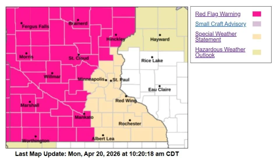
According to the National Weather Service, near-critical to critical fire weather conditions are expected to develop through the afternoon, with some areas facing even higher levels of concern.
Fire Danger Levels Across the Metro
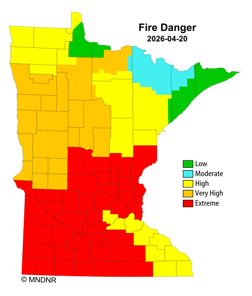
Fire danger varies by county, but much of the metro is under heightened risk:
High Fire Danger: Dakota, Scott, and Carver counties
Extreme Fire Danger: Hennepin, Ramsey, Anoka, and Washington counties
These classifications reflect how easily fires can start and how quickly they can spread under current conditions.
The Minnesota Department of Natural Resources warns that under high fire danger, fires can start easily and spread rapidly, while under extreme fire danger, fires can ignite quickly, spread aggressively, and become very difficult to control.
While the most intense conditions and an official Red Flag Warning are focused across central, western, and southwestern Minnesota, the Twin Cities region is still expected to see near-critical fire weather conditions this afternoon.
Provided by the MnDNR: Fire Danger and Burning Restrictions
Why Today’s Conditions Are So Dangerous
Several weather factors are combining to create a volatile fire environment:
Temperatures: Climbing into the upper 50s to lower 60s across the metro
Relative Humidity: Dropping to 20–30%, meaning very dry air
Winds: Southerly winds sustained at 10–20 mph, with gusts up to 25–30 mph
This setup is being driven by a strong southerly flow as high pressure shifts east into the Ohio Valley, pulling in warmer, but very dry air across Minnesota.
Low moisture levels, particularly dewpoints only in the 20s, allow vegetation like grass and brush to dry out quickly. When combined with gusty winds, even a small spark can rapidly grow into a fast-moving fire.
Safety Reminder: Avoid Outdoor Burning
Officials are strongly urging residents to:
Avoid any outdoor burning, including brush piles and recreational fires
Properly dispose of cigarettes and smoking materials
Use caution with equipment that could create sparks
Check local burning restrictions before any planned fire activity
Even routine activities, like dragging chains, using power equipment, or parking on dry grass, can spark a fire under these conditions.
Conditions Improve Tonight — But Watch Midweek
Winds are expected to diminish after sunset, helping to reduce the immediate fire threat. However, dry conditions will persist, and warmer temperatures are expected through midweek, with highs potentially reaching the 70s and even 80s by Wednesday.
While increased moisture may slightly reduce fire risk later in the week, officials say elevated fire weather concerns could continue, especially if winds remain breezy.
Bottom Line
Today, a combination of dry air, warm temperatures, and gusty winds has created a serious fire risk across the Twin Cities, especially in counties under extreme fire danger.
Residents are urged to take precautions and avoid any activity that could spark a fire, as conditions are favorable for rapid fire growth.