
Published: November 2, 2026
TWIN CITIES, MINNESOTA: A slow-moving storm system will bring several rounds of widespread rain to the Twin Cities metro and much of Minnesota beginning today (Monday) and continuing through Wednesday. The rainfall could provide some much-needed relief to areas experiencing ongoing drought conditions across the state.
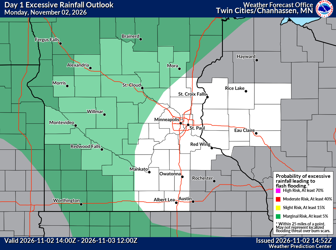
Moderate to occasionally heavy rainfall is possible, with some locations experiencing standing water or ponding on roads, parking lots, and other low-lying areas. However, the greatest concern for excessive rainfall and localized flash flooding currently remains west and north of the Twin Cities metro.
The NOAA Weather Prediction Center (WPC) has placed portions of western and central Minnesota under a Marginal Risk (Level 1 of 4) for excessive rainfall through early Tuesday morning. This means isolated flash flooding is possible, especially where heavier rainfall develops or persists, but the threat should be primarily west of the Twin Cities Metro.
What to Expect in the Twin Cities
Monday: Widespread rain throughout the day, occasionally moderate to heavy, with a possible break in rainfall later this afternoon or tonight.
Tuesday: Additional rounds of rain develop as the storm system slows down over the region. High temperatures remain relatively mild, generally in the 60s.
Wednesday: Rain continues before the system gradually moves east. Temperatures turn cooler.
Thursday–Friday: Rain gradually ends, with drier conditions returning by Friday. High temperatures settle back into the 40s and 50s.
How Much Rain Could Fall?

Rainfall totals of approximately 0.75 to 2 inches are expected across much of the region through Wednesday, although amounts will vary depending on where the heaviest rain bands develop. Some portions of central Minnesota could approach 3 inches, while localized totals of 3 to 5 inches are possible farther north, particularly where multiple rounds of heavy rainfall overlap.
The exact placement of the heaviest rainfall remains uncertain and could shift as the storm develops.
Flooding Concerns
While the Twin Cities metro is not currently in the WPC's highlighted excessive rainfall risk area for today, heavier rain could still cause localized drainage issues, ponding on roadways, and standing water in areas with poor drainage.
The more significant excessive rainfall and flash flooding concern is focused on areas west and north of the metro, where higher rainfall totals are currently favored.
Rainfall Could Bring Much-Needed Drought Relief
Despite the potential for localized water issues, this storm could deliver some of the most beneficial rainfall Minnesota has experienced in recent weeks, particularly across central and northern portions of the state.
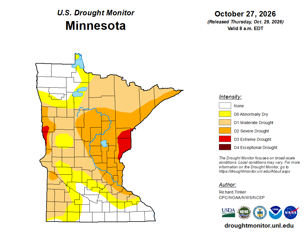
According to the latest U.S. Drought Monitor, released October 29th, significant portions of central and northern Minnesota remain in moderate to severe drought (D1–D2), with pockets of extreme drought (D3) in east-central and western Minnesota. While much of the southern Twin Cities metro is currently outside the more significant drought classifications, drought conditions remain a concern across other parts of the state.
Recent climate records also highlight the ongoing precipitation deficit.
At Minneapolis–Saint Paul International Airport (MSP), the official climate reporting station for the Twin Cities, year-to-date precipitation totaled just 21.88 inches through November 1st, compared to a normal 28.95 inches for the same period. That puts the Twin Cities 7.07 inches below normal, or approximately 24% less precipitation than typically received by this point in the year.
Twin Cities Precipitation Deficit
Observed precipitation: 21.88 inches
Normal precipitation: 28.95 inches
Deficit: 7.07 inches
Percent of normal: Approximately 76%
With vegetation largely dormant and the ground not yet frozen, much of the incoming rainfall should soak into the soil, helping replenish moisture levels and potentially improving streamflows and lake levels.
Portions of northern Minnesota, particularly near the headwaters of the Mississippi River, could receive as much as 3 to 5 inches of rain if the heaviest rainfall bands overlap. Such amounts would represent more than three times the region's typical precipitation for the entire month of November in just a few days.
Although one storm will not necessarily eliminate long-standing drought conditions, a widespread soaking rainfall of this magnitude could provide meaningful relief, especially in areas that have struggled with recurring drought since 2021.
Cooler Weather Follows the Rain
After a relatively mild start to the week, with highs in the 60s Monday and Tuesday, temperatures will gradually fall back into the 40s and 50s for the remainder of the week.
Drier conditions are expected by Friday, although a few additional opportunities for lighter rainfall could return over the weekend.
Bottom Line: Expect a wet start to November across the Twin Cities, with several rounds of rain through Wednesday. While occasional heavy downpours and roadway ponding are possible locally, the highest risk for excessive rainfall and flash flooding currently remains west and north of the metro.
For drought-affected areas across Minnesota, however, this storm could provide a welcome boost to soil moisture, streams, rivers, and lakes heading into the winter months.
Written By: Meteorologist Will Wight
