
Multiple Rounds of Rain Bring Widespread 1 to 2 Inches Across Twin Cities Metro, Isolated Higher Totals Reported
Published: June 24, 2026
TWIN CITIES, MINNESOTA - Multiple rounds of showers and thunderstorms moved across the Twin Cities metro area on Tuesday, June 23, 2026, bringing widespread beneficial rainfall, occasional heavy downpours, gusty winds, and scattered reports of storm-related damage.
The storms prompted several Special Weather Statements from the National Weather Service throughout the afternoon and evening as pockets of heavy rain and gusty winds developed across the region. While the storms generally remained below severe limits, they were capable of producing torrential rainfall, frequent lightning, and wind gusts strong enough to bring down tree limbs and power lines.
According to preliminary 24-hour rainfall reports from the Community Collaborative Rain, Hail and Snow Network (CoCoRaHS), much of the Twin Cities metro received between 0.80 and 1.60 inches of rain, with several locations recording significantly higher amounts.
Highest Rainfall Totals Reported
The heaviest rainfall appeared to fall across portions of the southwest and south metro, where some observers measured nearly two inches of rain.
Among the highest reported totals shown on the CoCoRaHS map were:
1.78 inches south-southwest of Chanhassen
1.75 inches in the Savage area
1.73 inches near St. Paul
1.72 inches west of Minneapolis
1.56 inches near Burnsville
1.69 inches near Prior Lake
Numerous additional reports between 1.40 and 1.60 inches across Dakota, Scott, Hennepin, Ramsey, Carver, and Washington counties
Across the south metro, rainfall totals generally ranged from 1.10 to 1.60 inches, including many reports in Apple Valley, Burnsville, Eagan, Rosemount, Lakeville, Savage, and Prior Lake.
Rainfall Totals by Community (Selected Reports)
Burnsville area: generally 1.20 to 1.60 inches
Savage area: generally 1.50-1.75 inches
Shakopee area: generally 1.50 to 1.60 inches
St. Paul area: up to 1.73 inches
Apple Valley area: generally 1.00 to 1.60 inches
Rosemount area: generally 1.00 to 1.60 inches
Lakeville area: generally 1.00 to 1.60 inches
Eagan area: generally 1.10 to 1.50 inches
Minneapolis area: generally 0.90 to 1.45 inches
Woodbury area: generally 0.80 to 0.95 inches
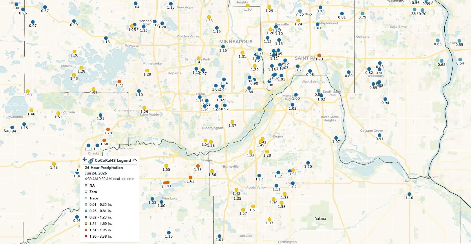
CoCoRaHS 24-hour precipitation reports ending June 24, 2026, show widespread rainfall totals of 1 to 2 inches across much of the Twin Cities metropolitan area.
Heavy Rain and Gusty Winds Prompt Weather Alerts
As storms developed Tuesday afternoon, the National Weather Service issued several Special Weather Statements warning of locally heavy rainfall, frequent lightning, penny-sized hail, and wind gusts capable of producing minor damage.
Reports from across the metro indicated numerous instances of downed tree limbs and isolated power outages. Emergency dispatch traffic also included calls for wires down and storm-related hazards in several communities.
While widespread flooding was not reported, some locations experienced brief ponding on roads during the heaviest downpours.
Lightning Strikes Reported in South Metro
The storms also produced several cloud-to-ground lightning strikes across the southern Twin Cities suburbs. In Apple Valley, emergency crews responded shortly after 4:00 p.m. to a report of a tree struck by lightning near Guild Avenue and 134th Street West. Firefighters were dispatched to investigate after reports of a tree being directly hit during the storm.
Just minutes later, at approximately 4:10 p.m., Apple Valley Fire and Police were called to the area of Garden View Drive and 136th Court for reports of an electrical fire. Initial reports indicated that a telephone pole may have been on fire. A second call reporting an electrical fire came in shortly afterward. Following an investigation, responders determined the incidents were likely related to the same event and may have been connected to a transformer failure caused by the storm.
As crews investigated the reports, Garden View Drive was temporarily closed to allow emergency personnel to safely assess the situation and ensure there were no ongoing hazards.
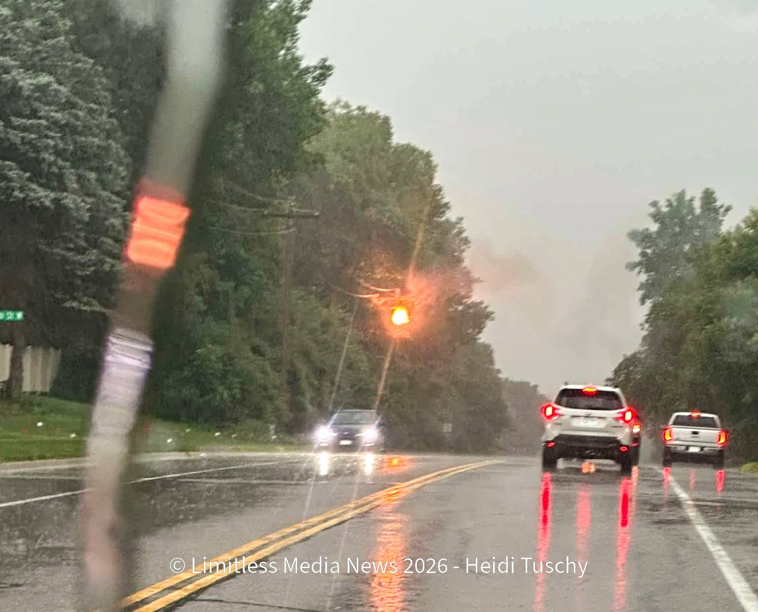
Photo of a telephone on fire along Garden View in Apple Valley, MN, provided to Limitless Media News by Heidi Tuschy.
Attention Turning to Potentially Hottest Weather of the Year
While Tuesday's rainfall was the immediate weather story across the Twin Cities, we’re monitoring a pattern shift expected to arrive this weekend. After several days of relatively mild temperatures and periodic rounds of rain, a strong ridge of high pressure is forecast to build over the central United States, allowing heat and humidity to surge northward into Minnesota.
Current forecasts indicate temperatures could climb into the mid to upper 90s beginning Sunday and continuing into next week, while dew points rise into the 70s, creating potentially oppressive humidity levels across the region. If the forecast holds, the combination of heat and humidity could produce dangerous heat index values exceeding 100 degrees, especially on Monday, and may result in the hottest conditions the Twin Cities metro has experienced so far in 2026.
While several days remain before the peak of the anticipated heat, confidence is growing that Minnesota will transition from the recent cooler and wetter weather pattern to one dominated by summer heat and humidity.
Limitless Media will publish a more in-depth weather outlook later today, examining the potential duration of the heat, expected heat index values, overnight temperatures, and what residents can do to stay safe if the forecast conditions materialize.
Written by: Will Wight