
Winter Storm Dumps Up to 7 Inches Across Twin Cities, Triggers Hundreds of Crashes and Widespread Flight Disruptions
Published: December 29, 2025.
TWIN CITIES, MINNESOTA - A powerful winter storm impacted the Twin Cities and much of southern and central Minnesota from Sunday, December 28, into early Monday, December 29, bringing widespread snowfall, strong winds, hazardous travel conditions, and significant disruptions to both roadway and air travel.
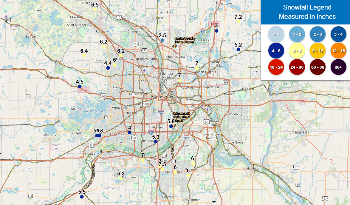
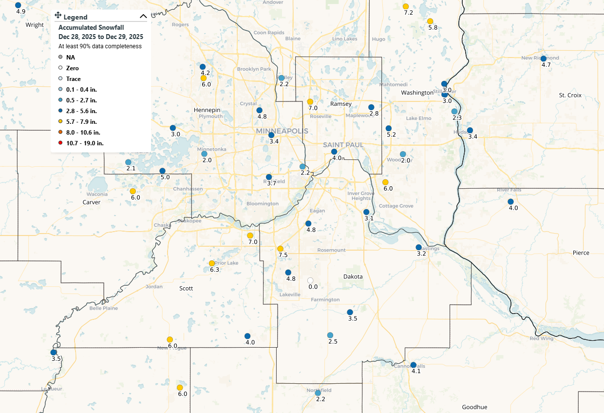
Twin Cities Snowfall Reports
Volunteer snowfall reports from the Community Collaborative Rain, Hail and Snow Network (CoCoRaHS) and the National Weather Service Twin Cities showed that most of the Twin Cities metro received 3 to 7 inches of snow, with locally higher amounts in the south metro.
Notable snowfall totals included:
Rosemount / Lakeville: up to 7.5 inches
Prior Lake: approximately 6.3 inches
Chaska and western Scott County: near 6 inches
Eagan and Bloomington: generally 4.5 to 5 inches
Minneapolis and Saint Paul: mostly 3 to 4 inches
Washington County: generally 2 to 5 inches
Strong Wind Gusts Worsened Visibility
In addition to snowfall, the storm brought strong northwest winds, further degrading road conditions.
According to the National Weather Service, peak wind gusts across the metro ranged from 35 to 45 mph, with higher gusts reported in exposed and rural areas. These winds caused blowing and drifting snow, creating near-whiteout conditions at times, particularly on open highways and rural roadways.
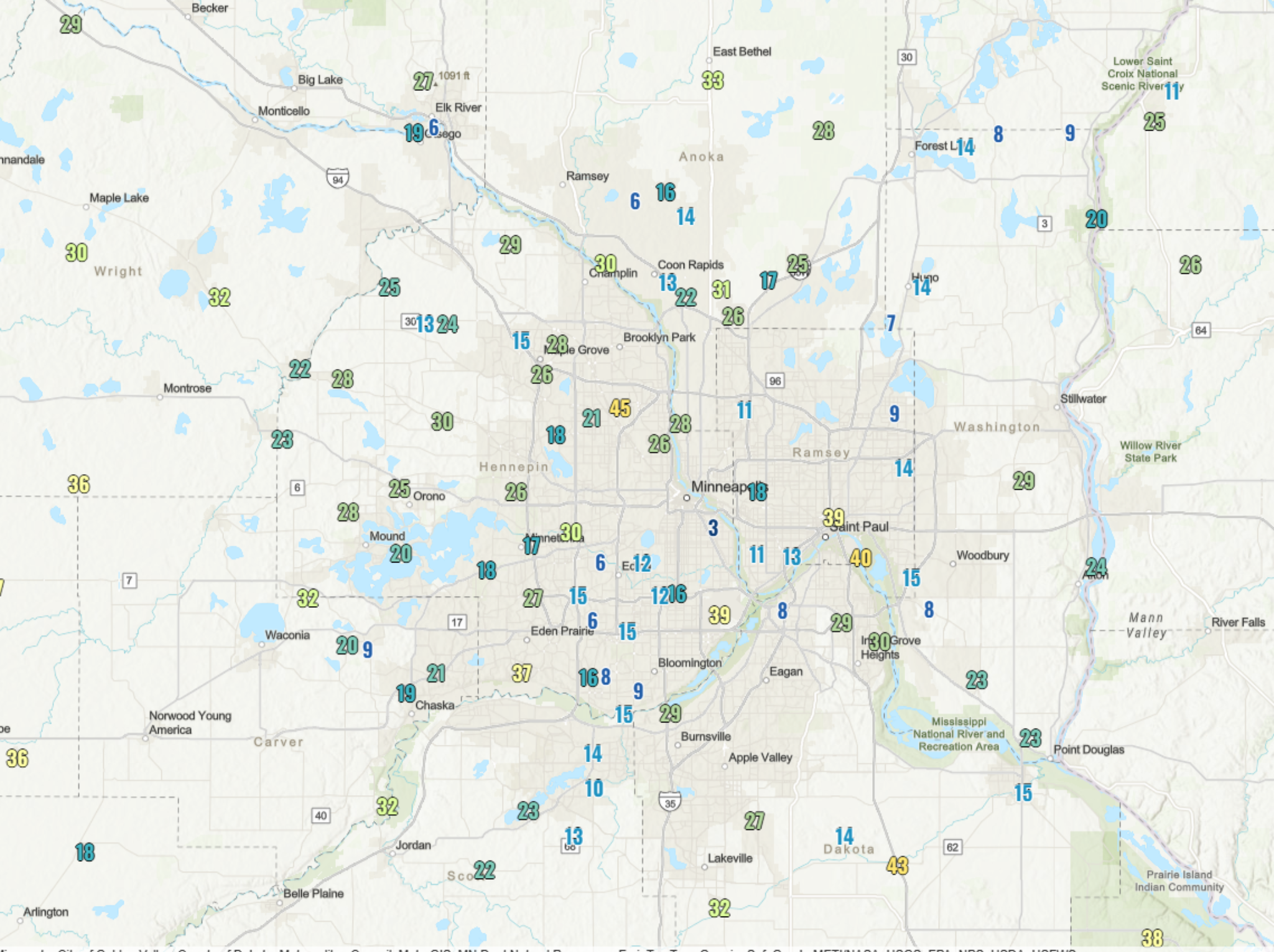
Max wind gusts in MPH for December 28, 2025, per the NWS.
Minnesota State Patrol Reports Hundreds of Crashes Statewide
The combination of snow-covered roads, drifting snow, and reduced visibility led to several crashes statewide, according to the Minnesota State Patrol PIO on X.
Total crash statistics from Sunday, Dec. 28, through Monday morning, Dec. 29 (midnight–7 a.m.) include:
418 property damage crashes
33 injury crashes
37 spin-outs
458 vehicles off the roadway
32 jackknifed semi-trucks
Troopers repeatedly urged motorists to slow down, increase following distance, and avoid unnecessary travel during the height of the storm.
MSP Airport Sees Tens of Thousands of Delays, Thousands of Cancellations
Air travel was also heavily impacted at Minneapolis–Saint Paul International Airport (MSP), with the storm causing ripple effects across airline networks. Below are the reported stats for the MSP Airport from Sunday into Monday for delays and cancellations according to FlightAware.
Sunday, December 28:
31,706 total flight delays worldwide
10,982 delays involving U.S. flights
1,559 total flight cancellations
848 U.S.-related cancellations
So Far Today - Monday, December 29:
15,377 total flight delays
2,032 delays involving U.S. flights
863 total cancellations
507 U.S.-related cancellations
Combined storm impact (Sunday–Monday):
47,083 total flight delays
13,014 U.S.-related delays
2,422 total flight cancellations
1,355 U.S.-related cancellations
Airlines continued recovery operations Monday as crews worked to reposition aircraft and manage lingering weather-related disruptions.
Cleanup Continues, Caution Urged
Road crews across the metro and greater Minnesota continued plowing and treating roadways into Monday. However, officials warned that drifting snow and icy patches could persist, especially in open and rural areas where gusty conditions could continue to cause blowing and drifting snow.
A Winter Weather Advisory remains in place across much of central and southeastern Minnesota today through this evening due to the threat of blowing and drifting snow and slick conditions on roads, bridges, and overpasses.
Drivers are encouraged to monitor road conditions, allow extra travel time, and keep winter safety kits in their vehicles as cleanup efforts continue across the state.
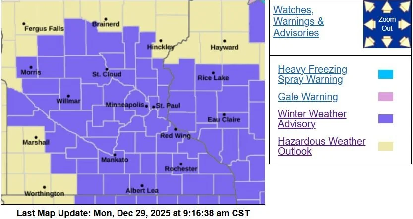
Winter Weather Advisory remains in effect until 6 PM CST this evening. Provided by the NWS Twin Cities.
Written by: Will Wight