
Near-Record Warmth, Strong Winds Expected Across Twin Cities This Weekend Before Cooler Weather Returns
Published: October 9, 2026
TWIN CITIES, MINNESOTA: An unusually warm October weekend is ahead for the Twin Cities metro and much of Minnesota, with temperatures climbing well above seasonal averages and potentially approaching record levels on Saturday. However, the combination of unseasonably hot temperatures, dry conditions, and strong winds will also increase the risk of rapidly spreading fires, particularly across western Minnesota.
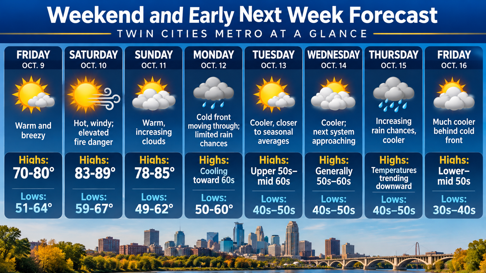
Temperatures are forecast to climb today (Friday) as a surge of warmer air moves into the Upper Midwest late this morning and into the afternoon from the southwest. The warmest conditions are expected Saturday, when afternoon highs could reach the mid-to-upper 80s across much of the region, with portions of western Minnesota potentially approaching 90 degrees.
The unusually warm conditions will continue Sunday before a cold front moves across the region late Sunday into Monday, bringing temperatures closer to seasonal averages. Another, potentially stronger weather system is expected to arrive during the middle to latter part of next week, bringing increasing chances for rainfall and another significant drop in temperatures.
Friday: Warm, Breezy Conditions Begin the Weekend
Today marks the start of a substantial warming trend across Minnesota as southerly winds transport warmer air into the region, otherwise known as warm air advection. Afternoon temperatures are expected to climb into the 70s across much of the Twin Cities metro, with the warmest locations in western Minnesota potentially reaching around 80 degrees.
Breezy conditions are also expected throughout the day as southerly winds increase, helping transport this warm air northward. Although winds will be noticeable, the strongest gusts should hold off until Saturday.
Afternoon highs will range from 70 to 80 degrees across the broader region, with overnight lows ranging from the lower 50s to the mid-60s.
Saturday: Near-Record Heat, Strong Winds and Elevated Fire Danger
Saturday is expected to be the warmest and potentially most impactful day of the weekend, with temperatures reaching levels more typical of midsummer than early October. Afternoon highs on Saturday are forecast to range from 83 to 89 degrees across the region, with portions of western Minnesota potentially nearing 90 degrees. Temperatures this warm during October are significantly above normal and could approach daily record highs at some locations.
In addition to the heat, strong southerly winds are expected to develop late Saturday morning and continue through the afternoon. Wind gusts of 30 to 40 mph will be possible, with the strongest winds most likely across parts of western Minnesota.
The combination of hot temperatures, dry air, and gusty winds could produce near-critical fire weather conditions Saturday, particularly across western Minnesota. Under these conditions, fires that develop in dry vegetation could spread rapidly and become difficult to control, especially in open areas exposed to strong winds. Residents planning outdoor burning or activities involving open flames should use extra caution, especially in areas with the strongest winds and driest conditions. Even small ignition sources could become problematic if fires spread into dry grasses or other vegetation.
Although the greatest fire weather concerns are currently focused on western Minnesota, residents across the Twin Cities metro should also remain mindful of the increased winds and unusually warm conditions. Especially since the entire Twin Cities metro is under some form of drought, from abnormally dry to severe drought.
Saturday night will remain relatively mild for October, with overnight lows ranging from the upper 50s to upper 60s across the broader area.
Sunday: Another Warm Day Before a Cold Front Approaches
Unseasonably warm conditions will continue into Sunday, although temperatures are expected to be slightly lower than Saturday's peak. Afternoon highs are forecast to range from 78 to 85 degrees, with increasing cloud cover throughout the day. The continued warmth will be associated with southerly airflow ahead of an approaching cold front connected to a low-pressure system near the Canadian border.
This cold front is forecast to move across the Upper Midwest sometime late Sunday into Monday. However, there remains uncertainty about the exact timing of the frontal passage. The timing will influence how quickly temperatures fall and how long the unusually warm conditions persist. Despite the approaching front, widespread rainfall is not currently anticipated because of limited moisture availability. So there is little potential for meaningful, much-needed precipitation. A few models do suggest isolated showers could develop as the front passes; though, as previously mentioned, rainfall amounts remain minimal, generally only a few hundredths of an inch in scenarios where precipitation occurs.
As a result, many locations across the Twin Cities metro could experience the frontal passage with little or no measurable rainfall.
Monday and Tuesday: Temperatures Return Closer to Normal
A noticeable change in the weather pattern is expected early next week as cooler air moves into Minnesota behind the cold front. Following several days of temperatures in the upper 70s and 80s, afternoon highs are expected to fall into the upper 50s to mid-60s once the cooler air mass becomes established.
Depending on the front's exact timing, Monday's temperatures could vary, with locations that see an earlier frontal passage cooling more quickly. By Tuesday, temperatures should be much closer to typical mid-October values across the Twin Cities metro.
Wednesday into Thursday: Increasing Rain Chances, Another Cold Front
A second weather system is expected to approach the Upper Midwest Wednesday night into Thursday, bringing what could be the next-best opportunity for meaningful rainfall during the week. Unlike Sunday into Monday’s cold front, this system is expected to be considerably stronger and bring more moisture.
While it is still early to pinpoint exact amounts, some model solutions suggest rainfall totals of a half-inch or more could occur in portions of the region. However, the strongest precipitation signal currently remains northwest of the Twin Cities, and the eventual storm track will determine where the heaviest rainfall develops. Changes in the system's track over the coming days could shift that rain corridor, so expect additional updates later this week.
While confidence is increasing that another weather system will affect the region, the timing, coverage, and amount of rainfall remain uncertain.
Friday: Another Significant Cooldown Possible
Behind the late-week cold front, temperatures are expected to fall even further. By Friday, October 16, afternoon highs could struggle to climb beyond the lower to mid-50s across much of the region.
That would mark a dramatic reversal from the near-record warmth expected just six days earlier, with some locations potentially experiencing a temperature difference of more than 30 degrees between Saturday's highs and the following Friday. The cooler conditions would bring a much more typical mid-October feel to the Twin Cities and surrounding communities.
Looking Ahead
The Twin Cities metro is preparing for an unusually warm October weekend, with Saturday bringing the greatest combination of heat, strong winds, and elevated fire weather concerns. Temperatures approaching 90 degrees in parts of western and southwestern Minnesota will be followed by a substantial cooling trend as a cold front crosses the region late Sunday into Monday.
Although the first front is unlikely to produce widespread rainfall, a stronger system arriving Wednesday night into Thursday could bring a better chance of precipitation before another round of cooler weather settles across Minnesota.
Written By: Meteorologist Will Wight
