
Heavy Rain Targets Twin Cities Friday, With Flooding Concerns Increasing Across Southern Minnesota
Published: September 18, 2026
TWIN CITIES, MINNESOTA: A moisture-rich storm system moving across Minnesota as we speak is expected to bring a soaking rain to the Twin Cities throughout the day today, with widespread rainfall totals around 1 to 2 inches possible across much of the region and a greater threat for excessive rainfall developing farther south and southeast this evening.
The latest forecast rainfall maps from the 12Z HRRR model from WeatherFront through approximately 1 p.m. Saturday indicate totals around 1.2 inches in Apple Valley, 1.06 inches in Lakeville, 1.3 inches in Eagan, 1.15 inches in Bloomington, 1.35 inches in Inver Grove Heights, and roughly 1.06 inches in St. Paul are possible. Areas farther south could receive considerably more, with projections increasing toward Northfield, Cannon Falls and southeastern Minnesota.
First Round Expected to Bring Widespread Soaking Rain
The disturbance bringing us this rain is moving around the northern edge of a large ridge of high pressure centered over the south-central United States. Warm, moist air moving northward is combining with atmospheric forcing associated with the disturbance to produce the broad area of precipitation that we are seeing. Unlike a summertime thunderstorm complex that can produce highly localized rainfall totals, the first part of Friday's event is expected to bring mostly persistent light to moderate rain, which we are seeing right now.
Instability is expected to remain relatively limited during this initial round, keeping the risk of flash flooding comparatively low across the Twin Cities during the daytime hours. That does not mean the rainfall won’t be significant.
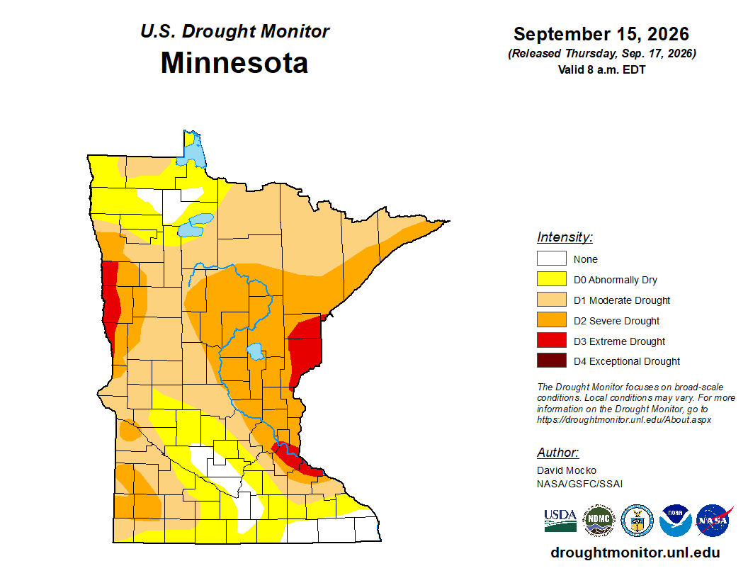
Parts of southern Minnesota are expected to receive a substantial soaking, which comes as portions of the state continue to experience drought conditions. The latest U.S. Drought Monitor map released yesterday, Thursday, September 17, 2026, shows moderate to severe drought across substantial portions of Minnesota, with pockets of extreme drought into parts of the Twin Cities metro, including across Dakota, Goodhue, Ramsey, Hennepin, and Washington Counties.
The Twin Cities climate station at MSP Airport recorded 0.39 inches of precipitation Thursday, according to the National Weather Service climate report. Through September 17th, precipitation for the month stood at 1.62 inches, about 0.08 inches below normal. Since January 1, however, the station has recorded 17.91 inches, about 7.03 inches below normal, and a prime example of why we are seeing extreme drought across parts of the Twin Cities metro.
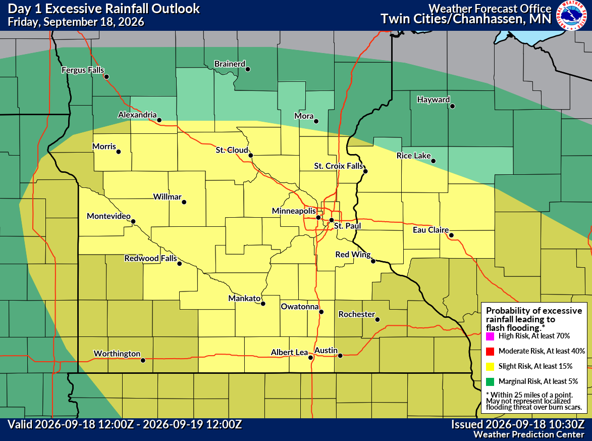
Today’s rain could be beneficial for lawns, vegetation, and agricultural areas, although heavier amounts could cause localized flooding, and it's why a large portion of the state is currently under a Slight risk (2/4) for excessive rain and flash flooding from the Weather Prediction Center (WPC) today into early tomorrow morning.
Heavier Rain Threat Develops Friday Evening
By Friday evening, a warm front strengthens across Iowa, and a low-level jet transports increasingly warm, moisture-rich air northward. Atmospheric moisture is forecast to become unusually high for this time of the year, with precipitable water values approaching 2 inches. Instability could climb across northern Iowa and parts of far southern Minnesota, setting the stage for thunderstorms capable of producing very heavy rainfall.
As we mentioned earlier, the WPC expects the disturbance to move eastward across southern Minnesota and Wisconsin, while the developing low-level jet enhances thunderstorm development. Its guidance generally supports 2 to 4 inches of rainfall within the heavier precipitation corridor, with locally higher amounts possible. The WPC has a Slight Risk (2/4) for excessive rainfall in effect for the broader regional threat, meaning scattered flash flooding is possible. Forecast guidance suggests the most concerning corridor for the flooding threat could ultimately establish itself near the Minnesota-Iowa border, particularly east of I-35, rather than directly over the core Twin Cities metro, where the National Weather Service already has Flood Watches in place.
The Weather Prediction Center said the moisture-laden atmosphere could support local downpours as the system moves through the Upper Midwest.
Twin Cities Still Could Pick Up 1–2 Inches
For the immediate Twin Cities metro, current forecasts generally favor a prolonged soaking rain rather than the extreme rainfall totals that may develop closer to the Iowa border. Rainfall projections based on the latest 12Z HRRR model show totals generally between about 1 and 1.5 inches across the southern and eastern metro, including Dakota County. Forecast amounts increase farther south, with around 2.2 inches near Northfield and substantially higher projections around Cannon Falls and farther southeast.
The exact location of the heaviest rainfall remains important. A relatively small north or south shift in the thunderstorm axis could significantly change final totals in any particular community.
Rain is expected through much of Friday, with showers and thunderstorms remaining possible into Friday night. Easterly winds could gust around 25 mph during the day and potentially 30+ mph Friday night.
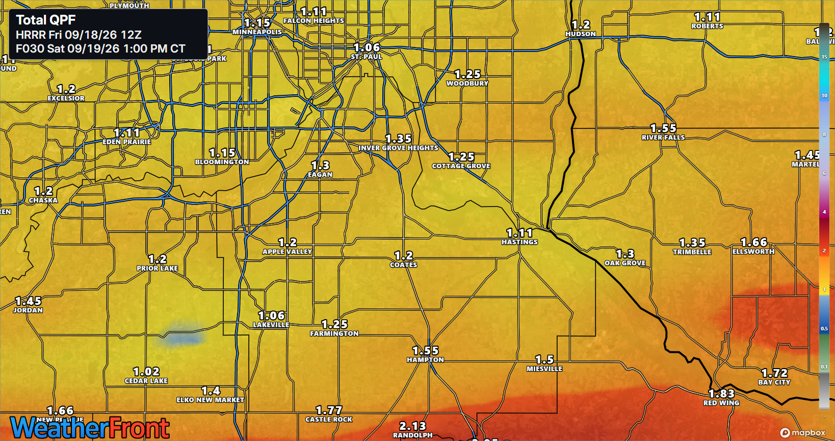
WeatherFront HRRR APCPT Sum F030 2026-09-19 0100 PM
Written By: Meteorologist Will Wight
