
Weekend Rain Delivers Widespread Soaking Across Twin Cities, But Drought Deficits Remain
Published: September 18, 2026
TWIN CITIES, MINNESOTA: A multi-day stretch of rain delivered a widespread soaking across the Twin Cities and southern Minnesota late last week, with rainfall totals generally reaching around 1 to 2 inches across the metro and topping 2 inches in portions of southern Dakota County. The rainfall largely matched the broad expectations we had outlined ahead of the storm Friday, when forecasts called for widespread totals of approximately 1 to 2 inches across the Twin Cities, with locally higher amounts expected farther south and southeast.
Official observations from Minneapolis-St. Paul International Airport, the climate observation site for the Twin Cities, show 1.10 inches of rain fell Friday and Saturday, including 0.89 inches on September 18th and another 0.21 inches on September 19th. No measurable precipitation was recorded on September 20th.
The storm pushed September precipitation at MSP to 2.72 inches through September 20th, which was 0.73 inches above the normal 1.99 inches expected by that point in the month. While the airport received just over an inch, observations across the southern metro show substantially higher totals in some communities.
Around 1–2 Inches Falls Across Much of Southern Metro
Community Collaborative Rain, Hail and Snow Network, or CoCoRaHS, observations accumulated from September 18 through September 21 show numerous reports between approximately 1.0 and 1.5 inches across Dakota, Scott, Hennepin and surrounding counties. Totals generally increased across portions of southern Dakota County.
Around Apple Valley, gauges reported approximately 1.15 to 1.36 inches, while Lakeville-area observations included totals ranging from around 1.1 inches to more than 1.50 inches. Near Farmington, observations showed around 15-2.01 inches measured. Around Rosemount, observations generally ranged from about 1.2 to 1.35 inches. Burnsville-area gauges were largely around 1 to 1.25 inches, while Eagan observations varied from less than an inch to approximately 1.3 inches.
The observations demonstrate how rainfall totals varied over relatively short distances, but also show that much of the southern metro received a substantial soaking.
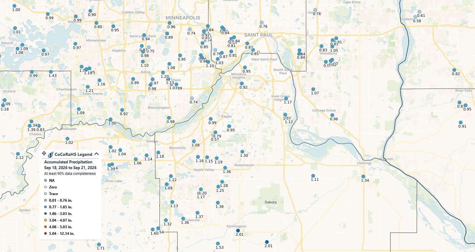
Provided by: CoCoRaHS
How Did the Forecast Compare With What Actually Happened?
Ahead of Friday's rainfall, forecast guidance examined by Limitless Media showed approximately 1.2 inches for Apple Valley, 1.06 inches for Lakeville, 1.3 inches for Eagan, 1.15 inches for Bloomington, 1.35 inches for Inver Grove Heights, and around 1.06 inches for St. Paul.
Those projections proved reasonably representative of the overall rainfall pattern. Apple Valley's forecast of around 1.2 inches, for example, was surrounded by observed totals generally between approximately 1.15 and 1.36 inches. Several observations around Eagan also finished near the forecast amount of approximately 1.3 inches, although other gauges recorded less. Lakeville shows the localized differences that can occur during a rain event. While the forecast called for around 1.06 inches, observations around the area ranged from near that amount to more than 1.5 inches.
At MSP, the 1.10-inch Friday-through-Saturday total came in near the lower end of the broader 1-to-2-inch forecast for the Twin Cities.
The forecast had also emphasized that the highest potential for excessive rainfall was expected south of the core Twin Cities, particularly toward southern and southeastern Minnesota, rather than directly over Minneapolis and St. Paul. That general southward increase was apparent in the observations, including the totals around 2 inches in southern Dakota County.
In other words, the storm largely behaved as expected across the metro: a widespread soaking of roughly an inch or more, with higher amounts becoming more common farther south.
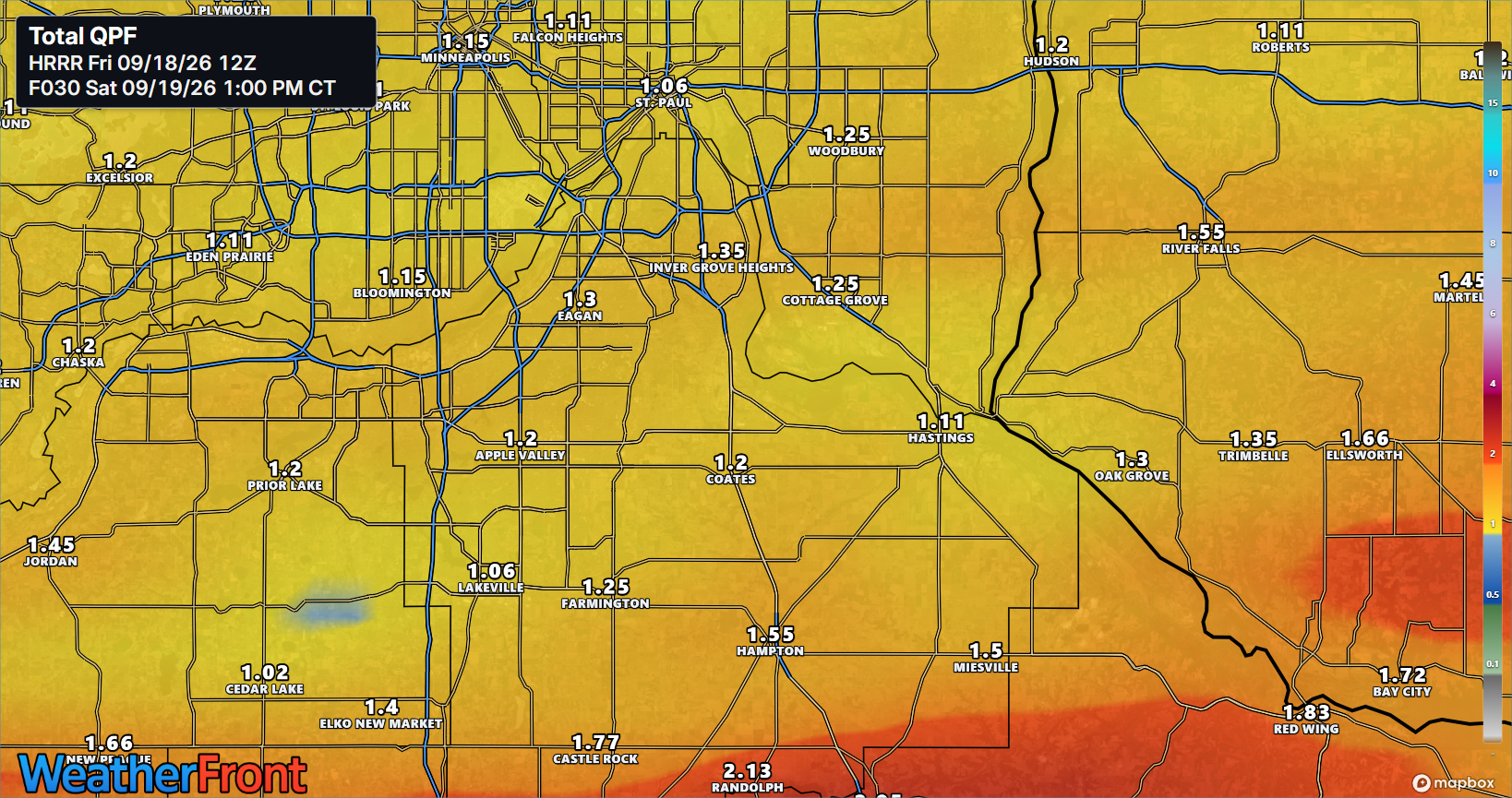
Previous prediction from Friday, September 18, 2026.
Rain Erases September Deficit at MSP
The storm also dramatically changed the September precipitation picture at the Twin Cities climate station. Before the main rain event, MSP had recorded 1.62 inches of precipitation through September 17th, which was 0.08 inches below normal for the month to that point. The airport received 0.89 inches on September 18th, bringing the monthly total to 2.51 inches. Another 0.21 inches on September 19th increased the total to 2.72 inches. By September 20th, MSP remained at 2.72 inches for the month, but the normal accumulation for the month to date was only 1.99 inches.
That means the Twin Cities went from 0.08 inches below normal September precipitation before the storm to 0.73 inches above normal afterward.
The recent wet stretch actually extends beyond Friday's storm. MSP received 0.61 inches on September 16th and 0.39 inches on September 17th, according to the National Weather Service climate reports. Combined with Friday and Saturday's rainfall, MSP received 2.10 inches of rain from September 16th through September 19th. That four-day period accounted for more than three-quarters of all precipitation recorded at MSP so far this month.
Significant Long-Term Rainfall Deficit Remains
Although the rainfall was beneficial, one wet stretch does not erase the longer-term precipitation deficit that developed during 2026. Through September 20th, MSP had recorded 19.01 inches of precipitation since January 1st. Normal precipitation through that date is 25.23 inches, leaving the Twin Cities climate station 6.22 inches below normal for the year. The recent rainfall did, however, make a noticeable dent in that deficit.
Following the September 16th rainfall, the year-to-date deficit stood at 7.32 inches. By September 17th, it had decreased to 7.03 inches. After Friday's 0.89 inches, the deficit dropped to 6.24 inches, then settled at 6.22 inches below normal through September 20th.
So while September has now become wetter than normal at MSP, the longer-term precipitation shortage remains substantial.
What Does the Rain Mean for Minnesota's Drought?
The soaking should provide some short-term drought relief, particularly by replenishing soil moisture and reducing immediate stress on lawns, vegetation and trees. However, it is too early to determine exactly how much the official drought classifications will change.
The latest U.S. Drought Monitor, released September 17th using conditions through September 15th, showed widespread drought continuing across Minnesota. According to the Minnesota Department of Natural Resources, 38% of Minnesota was in moderate drought, 28% in severe drought and 4% in extreme drought before this latest rainfall occurred.
That timing is important: the current Drought Monitor does not account for the rainfall that fell across the Twin Cities from September 16th through the weekend. The U.S. Drought Monitor uses a Tuesday morning data cutoff and releases its analysis Thursday, meaning the effects of this rainfall should be better reflected in subsequent updates. Drought is also measured using more than a few days of rainfall. Soil moisture, streamflow, groundwater, lake levels and precipitation over different time periods are among the factors used to evaluate drought conditions.
The Minnesota DNR reported earlier this month that seasonal precipitation from April 1st through early September remained below normal across much of central and northern Minnesota. At the time, 17% of Minnesota's topsoil moisture was rated very short and another 37% short. Longer-term hydrological impacts can take considerably longer to recover. The DNR has cautioned that areas experiencing what it calls a "storage drought" may need months of above-normal precipitation to replenish depleted lakes, soils and groundwater.
Helpful Rain, But More Is Needed
For the Twin Cities, the weekend storm represents meaningful progress. MSP has gone from slightly below-normal precipitation for September to nearly three-quarters of an inch above normal, and locations across the southern metro received about 1 to 2 inches from the main storm, but the 6.22-inch year-to-date precipitation deficit at MSP illustrates why several days of rain should not be confused with the end of drought concerns.
Minnesota's drought developed through accumulated precipitation shortages and periods of summer heat and dryness. The DNR says drought returned across the state this summer as long-term precipitation shortages combined with predominantly dry summer conditions.
For now, the latest rainfall should improve short-term moisture conditions across areas that received the soaking. Whether it produces measurable improvement in the Twin Cities' official drought classification will become clearer as updated precipitation, soil moisture, streamflow, and Drought Monitor data are released.
The next U.S. Drought Monitor, which is expected to be released on Thursday, September 24, 2026, will also provide the first clearer look at how much of the recent rainfall translated into drought improvement.
Written By: Meteorologist Will Wight
