
Frost Advisory Issued for Twin Cities as Freeze Warning Covers Southern Twin Cities Metro to Southern MN Saturday Morning
Published: October 16, 2026
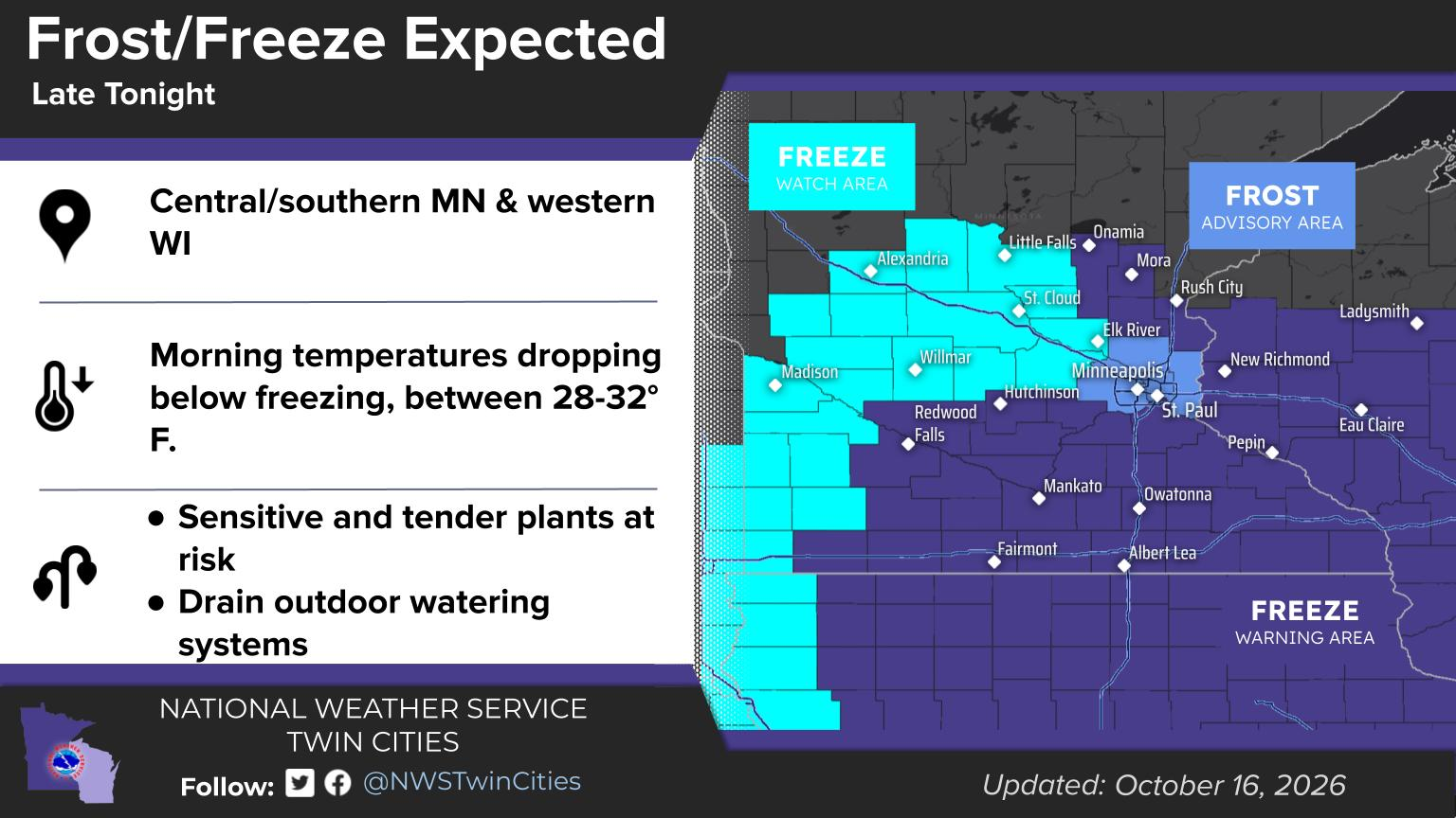
TWIN CITIES, MINNESOTA: The National Weather Service Twin Cities/Chanhassen has issued a Frost Advisory for portions of the Twin Cities metro area and a Freeze Warning for the southern Twin Cities into much of southern Minnesota and western Wisconsin as temperatures are expected to drop significantly overnight Friday into Saturday morning, October 17, 2026.
The alerts, issued at 1:18 a.m. Friday, October 16, come as clear skies, light winds, and high pressure create favorable conditions for widespread frost and freezing temperatures across the region. While temperatures in the urban core of the Twin Cities are expected to remain slightly above freezing, thanks to the urban heat island, communities south and east of the metro could experience temperatures falling into the upper 20s and lower 30s.
The National Weather Service warns that cold temperatures could damage or kill sensitive outdoor plants and crops, and hard freezes could also damage unprotected outdoor plumbing.
Frost Advisory Issued for Minneapolis, St. Paul, and Northern Metro
A Frost Advisory will be in effect from 1 a.m. until 8 a.m. Saturday, October 17, 2026, for four counties in the Twin Cities metropolitan area.
The advisory includes:
Hennepin County, including Minneapolis
Ramsey County, including St. Paul
Anoka County, including Blaine
Washington County, including Stillwater
Temperatures in these areas are expected to fall as low as 34 degrees, creating conditions favorable for frost formation despite temperatures remaining above the freezing mark of 32 degrees. According to the National Weather Service, the urban heat island effect in Minneapolis, St. Paul, and surrounding developed areas should keep temperatures slightly warmer than in communities farther from the urban core.
However, the combination of light winds, high relative humidity, and mid-30s temperatures is expected to allow frost to develop on exposed surfaces. Sensitive outdoor vegetation could be damaged or killed if left uncovered overnight.
The Frost Advisory replaces a previously issued Freeze Watch for these four counties, reflecting increased confidence that frost will occur but temperatures will generally remain above freezing.
Freeze Warning Includes Dakota, Scott, and Carver Counties
A more significant cold-weather threat is expected across the southern and southwestern Twin Cities metro, where the National Weather Service has upgraded a previous Freeze Watch to a Freeze Warning. The Freeze Warning will be in effect from 1 a.m. until 9 a.m. Saturday, October 17, 2026, with temperatures expected to fall into the upper 20s and lower 30s.
The warning includes several counties in and around the Twin Cities, including:
Dakota County, including Burnsville, Apple Valley, Eagan, Lakeville, Rosemount, and Hastings
Scott County, including Shakopee, Savage, and Prior Lake
Carver County, including Chaska, Chanhassen, and Victoria
McLeod County, including Hutchinson
Sibley County, including Gaylord
Rice County, including Faribault
Goodhue County, including Red Wing
Le Sueur County, including Le Sueur
The warning also includes additional counties across central, southern, and southeastern Minnesota, along with portions of western Wisconsin.
Unlike a Frost Advisory, which can be issued when temperatures remain above freezing, a Freeze Warning indicates that subfreezing temperatures are expected and could cause more widespread damage to vulnerable vegetation. Frost and freezing conditions could kill crops and other sensitive plants and potentially damage unprotected outdoor plumbing.
Freeze Warning Extends Into Western Wisconsin
The cold-weather threat will not be limited to Minnesota. A Freeze Warning has also been issued for portions of northwestern and west-central Wisconsin, including St. Croix, Pierce, Polk, Barron, Dunn, Pepin, Rusk, Chippewa, and Eau Claire counties. Communities including Hudson, River Falls, Osceola, Menomonie, Rice Lake, and Eau Claire are among those covered by the warning.
Temperatures across the warning area are expected to fall into the upper 20s and lower 30s early Saturday morning. The warning remains in effect until 9 a.m., when temperatures are expected to begin recovering following sunrise.
Freeze Watch Remains in Effect Northwest of the Metro
Meanwhile, a Freeze Watch remains in effect from late Friday night through Saturday morning for portions of central and western Minnesota. Counties under the watch include Sherburne, Wright, Stearns, Benton, Morrison, Todd, Kandiyohi, Meeker, Douglas, Pope, Stevens, Swift, Chippewa, Lac Qui Parle, and Yellow Medicine. Communities including St. Cloud, Elk River, Monticello, Willmar, Alexandria, and Little Falls are among those included.
Freezing temperatures remain possible in these areas, but stronger overnight winds could keep temperatures from dropping as much as initially expected. A Freeze Watch indicates conditions may support freezing temperatures, but uncertainty remains about whether those temperatures will develop.
Why Temperatures Are Expected to Drop So Quickly
A ridge of high pressure working over the region behind the front we saw work through yesterday will bring clear skies and light winds Friday evening. The clear skies and light winds will allow heat accumulated near the ground during the day to escape rapidly into the atmosphere after sunset, a process known as radiational cooling. As a result, temperatures are expected to fall quickly into the 30s Friday evening, with frost formation becoming likely across much of the region.
However, weather conditions will begin changing overnight. This area of high pressure is expected to shift back toward the southern Plains, allowing southerly return flow to increase across central and western Minnesota. Winds in those areas could increase to around 10 knots, or approximately 12 mph, late Friday night. That additional wind may mix warmer air down toward the surface, slowing the temperature decline and limiting further frost formation.
Farther south and east, however, winds are expected to remain lighter for much of the night, allowing temperatures to continue falling below freezing. This difference in overnight wind conditions is one of the primary reasons the National Weather Service issued different alerts across the region.
Residents Urged to Protect Plants and Outdoor Plumbing
With frost and freezing temperatures expected, residents are encouraged to take precautions before temperatures begin dropping Friday evening. Officials advise residents to protect tender plants from the cold.
Recommended precautions include:
Cover sensitive plants: Use frost blankets, sheets, or other breathable coverings to protect vulnerable outdoor vegetation. Covers should extend to the ground to help retain warmth.
Bring potted plants indoors: Move vulnerable flowers, herbs, and container plants into garages, sheds, or other protected areas.
Protect gardens and crops: Harvest remaining sensitive produce when possible, and cover plants you can't move.
Disconnect outdoor hoses: Remove garden hoses from exterior faucets and drain exposed watering equipment where freezing temperatures are expected.
Protect exposed plumbing: Take precautions to prevent freezing in vulnerable outdoor water lines and irrigation systems.
Monitor temperatures: Residents should watch local forecasts, especially near the boundaries between the Frost Advisory and Freeze Warning.
Even locations that remain slightly above 32 degrees can experience frost on exposed surfaces, particularly during clear, calm nights.
Coldest Temperatures Expected Early Saturday Morning
The greatest potential for freezing temperatures is expected overnight and early Saturday morning, particularly across the southern and eastern Twin Cities metro and western Wisconsin.
For residents in Dakota, Scott, and Carver counties, the Freeze Warning begins at 1 a.m. Saturday and continues through 9 a.m. In Minneapolis, St. Paul, and the northern metro, the Frost Advisory begins at 1 a.m. and expires at 8 a.m.
Although temperatures are expected to recover after sunrise, sensitive vegetation could still be damaged before conditions improve. Residents with gardens, outdoor flowers, or other vulnerable plants are encouraged to complete protective measures Friday evening rather than waiting until Saturday morning.
While conditions are being monitored, alerts may be updated or changed as additional forecast information becomes available.
Source: National Weather Service Twin Cities/Chanhassen
Photo Credit: National Weather Service Twin Cities/Chanhassen Weather Story
Written By: Meteorologist Will Wight
