
Twin Cities Ties Nearly Century-Old Heat Record Saturday, Breaks Sunday Record as October Warmth Continues
Published: October 11, 2026
TWIN CITIES, MINNESOTA: The Twin Cities experienced a remarkable stretch of unusually warm October weather this weekend, with Minneapolis–St. Paul International Airport tying a nearly century-old daily high temperature record Saturday before breaking another record Sunday afternoon.
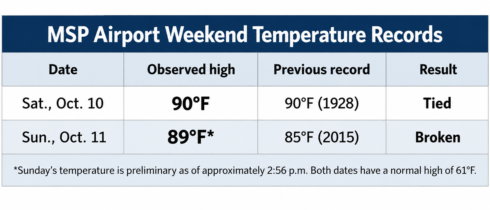
According to the National Weather Service (NWS) Twin Cities office in Chanhassen, temperatures at MSP Airport reached 90 degrees Saturday, October 10, tying the daily record established in 1928. The unusually hot weather continued Sunday, October 11, when temperatures climbed to at least 89 degrees, surpassing the previous daily record of 85 degrees set in 2015.
The back-to-back record-setting temperatures came during a period of exceptional October warmth across the region, with afternoon highs running more than 20 degrees above historical averages.
Saturday's 90-Degree Heat Ties Record From 1928
Saturday's 90-degree temperature at MSP Airport matched a record that had stood for 98 years. In a Record Event Report issued at 4:29 p.m. Saturday, the NWS confirmed that the airport reached 90 degrees, tying the previous daily record established on October 10, 1928. The agency's preliminary daily climate report, issued at 7:45 p.m., provided additional details about Saturday's unusual temperatures.
The high of 90 degrees was recorded at about 2:37 p.m., while the day's low was 60 degrees, recorded at about 3:06 a.m. Both temperatures were considerably warmer than normal for the date. The normal high temperature for October 10th is 61 degrees, meaning Saturday's afternoon high was 29 degrees above normal. The overnight low was also unusually warm, coming in at 17 degrees above the normal low of 43 degrees. For comparison, the high temperature on October 10, 2025, was 70 degrees, while the low was 47 degrees.
Saturday's high was therefore 20 degrees warmer than the same date last year.
While the temperature tied the daily record, it did not establish a new all-time October temperature record. The distinction matters because daily records reflect the highest temperature observed on a particular calendar date, not the highest temperature recorded during the entire month.
Sunday Breaks Record Established in 2015
The unusual warmth continued into Sunday, with temperatures climbing back into the upper 80s. At about 1:42 p.m., the NWS Twin Cities announced that MSP Airport had reached 85 degrees, tying the existing daily record for October 11th, with meteorologists at the time indicating additional warming was still possible this afternoon.
Just over an hour later, the temperature had climbed another four degrees. In an update published around 2:56 p.m., the NWS reported that MSP Airport had reached 89 degrees, officially surpassing the previous record. The NWS climate almanac says the former October 11th record of 85 degrees was set in 2015.
With Sunday's temperature reaching at least 89 degrees, the airport exceeded that record by four degrees, with a chance it could peak near 90F this afternoon. Sunday's normal high temperature is just 61 degrees, placing the observed afternoon temperature 28 degrees above normal.
The temperature also approached Saturday's 90-degree high, marking two consecutive days of exceptionally hot October weather in the Twin Cities. Unlike Saturday's record, which tied an existing mark, Sunday's temperature established a new daily record. The final official high for Sunday will be determined after the day's observations are completed.
How Unusual Is This October Warmth?
The weekend's temperatures stand out not only for the daily records but also for how late in the year they occurred. According to the NWS, October 10, 1928, previously held the distinction of being the latest date in the calendar year that the Twin Cities reached 90 degrees. Saturday's 90-degree reading matched that historical milestone, and if we reach it today, October 11th might be the new date!
The NWS maintains Twin Cities climate records dating back to 1871, providing more than 150 years of historical weather observations for comparison.
Cooler Temperatures Expected to Return
The record warmth is not expected to continue indefinitely. A cold front moving across Minnesota from northwest to southeast is expected to end the unusually hot conditions, with temperatures gradually returning closer to seasonal averages early in the week. The frontal passage may also bring scattered light rain, although the timing and coverage remain uncertain.
By mid-week, temperatures are expected to be considerably cooler than the upper 80s and 90-degree readings experienced this weekend.
For now, the weekend will be remembered as an extraordinary period of October warmth in the Twin Cities, with Saturday matching a record dating back nearly a century and Sunday surpassing a record established just 11 years ago. Sunday's final high temperature remains preliminary and could be revised once the NWS completes its daily climate observations.
Sources: National Weather Service Twin Cities/Chanhassen, Record Event Report (RERMSP), issued October 10, 2026, at 4:29 p.m. CDT; Twin Cities Daily Climate Report (CLIMSP), issued October 10, 2026, at 7:45 p.m. CDT; NWS Twin Cities climate almanac for October 11, 2026; and NWS Twin Cities social media updates published October 11, 2026, at approximately 1:42 p.m. and 2:56 p.m. CDT. Additional historical and meteorological context from National Weather Service climate records and forecast discussions.
Written By: Meteorologist Will Wight
