

Published: October 27, 2026 | Last Updated: October 28, 2026 at 9:15 AM.
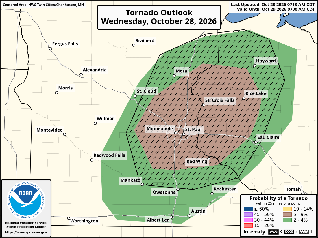
TWIN CITIES, MINNESOTA: The threat of severe weather across the Twin Cities metropolitan area has increased for Wednesday afternoon and evening, with the Storm Prediction Center (SPC) upgrading portions of eastern Minnesota and western Wisconsin to a Level 2 of 5 Slight Risk for severe thunderstorms.
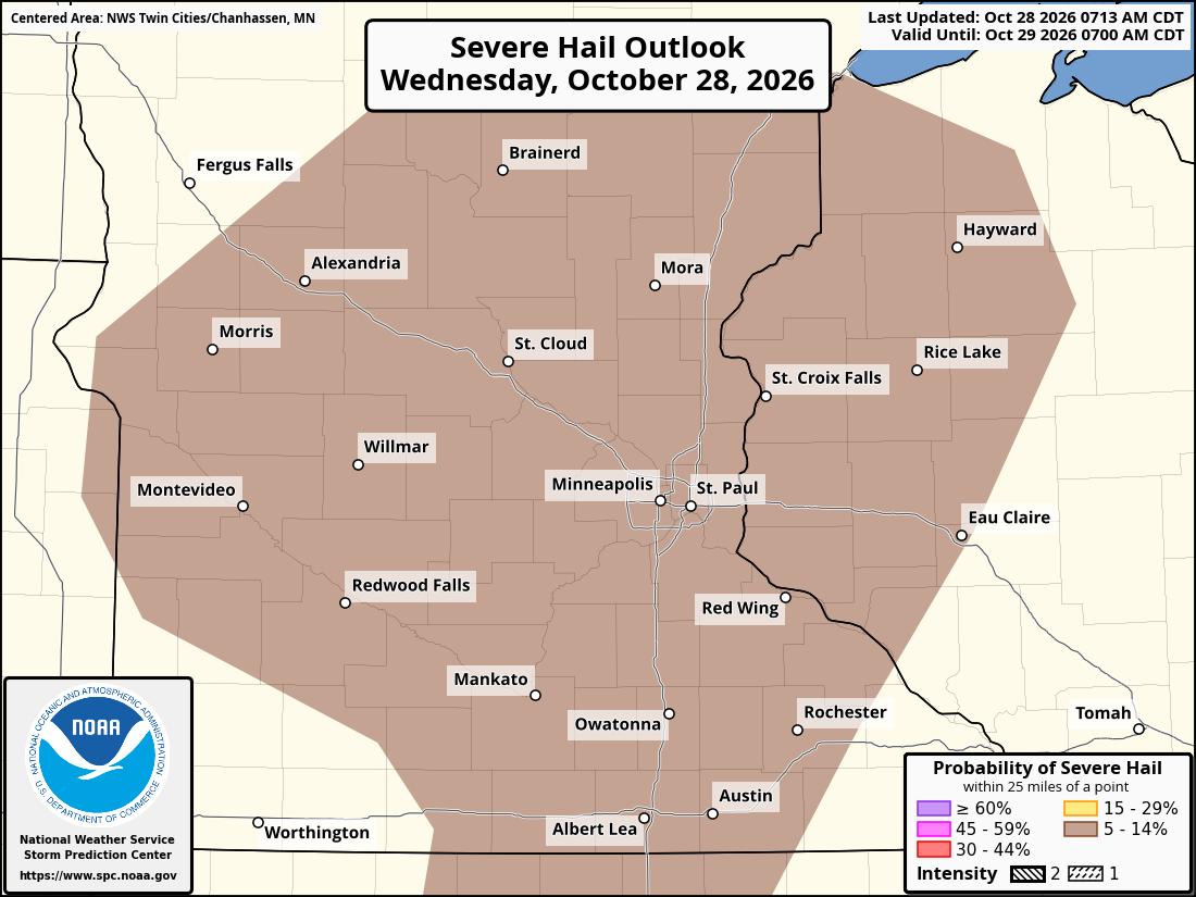
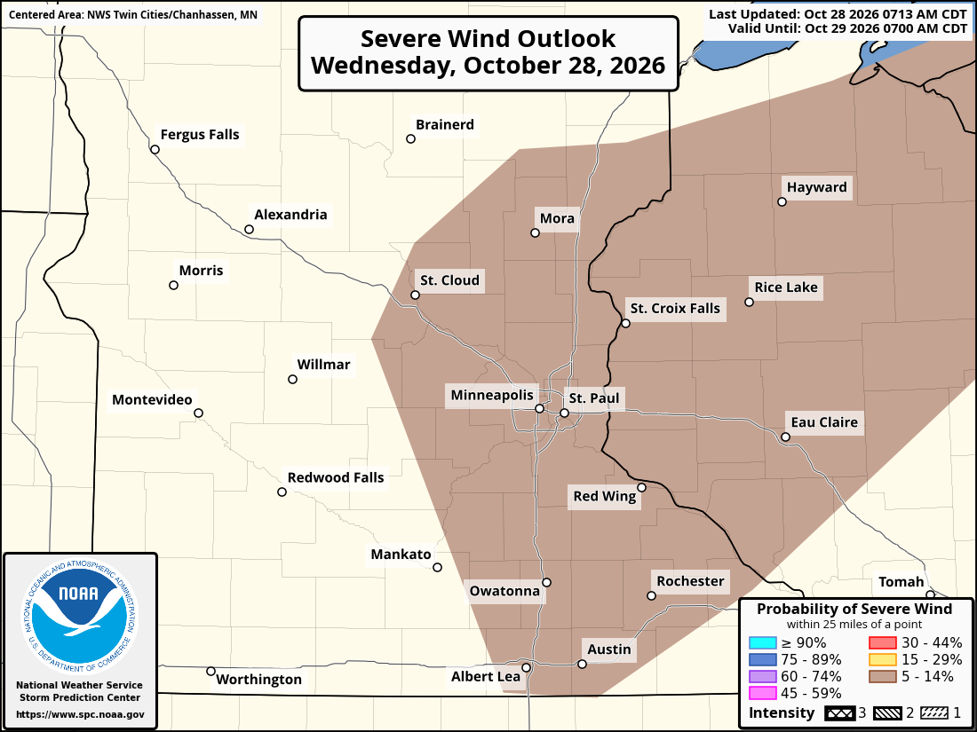
The upgraded outlook includes a small area around the Twin Cities metro and extends into western Wisconsin, where a few thunderstorms could become strong to severe in the afternoon and early evening. The primary hazards include isolated tornadoes, large hail, and damaging straight-line winds, particularly if thunderstorms can develop and take advantage of an increasingly favorable wind environment. The greatest potential is for a few intense thunderstorms, primarily between 3 p.m. and 8 p.m. CDT, across central Minnesota and into northwestern Wisconsin, including the Twin Cities metro.
Despite the increased severe weather risk, the forecast remains highly conditional. While wind conditions are favorable for organized thunderstorms and even tornadoes, uncertainty remains regarding whether sufficient atmospheric instability and moisture will develop to support severe storms. In other words, the ingredients for severe weather may be present, but whether they come together at the right time and location will determine how significant Wednesday's thunderstorms become.
Severe Weather Risk Upgraded for the Twin Cities
The SPC's upgrade from a Marginal Risk (Level 1 of 5) to a Slight Risk (Level 2 of 5) increases the potential for organized severe thunderstorms across portions of the region. A Slight Risk indicates that scattered severe thunderstorms are possible within the designated area, although severe weather is not guaranteed at any particular location.
The latest outlook highlights portions of central and eastern Minnesota, including the Twin Cities metropolitan area, extending into western and northwestern Wisconsin. The upgrade comes as confidence increases that an approaching weather system could produce thunderstorms that take advantage of strong wind shear, particularly during the mid-to-late afternoon hours.
However, the overall severe weather threat depends on how much instability develops ahead of an approaching cold front and in the system's warm sector.
Isolated Tornadoes Possible During the Afternoon
One of the more concerning aspects of Wednesday's forecast is the potential for a few tornadoes, despite relatively modest atmospheric instability. As we mentioned in our story yesterday, this is a typical setup we like to call a high-shear, low-CAPE environment, where forecast wind profiles are impressive, with winds changing direction and increasing considerably with height, but the instability (CAPE) is limited. We will again break this down in greater detail below.
Forecast storm-relative helicity values in the lowest kilometer of the atmosphere are expected to reach approximately 200 to 300 square meters per second squared. This measurement helps meteorologists assess the potential for rotating thunderstorms by evaluating how much horizontal rotation storms can ingest. These values, combined with strong wind shear, could support the development of rotating thunderstorms known as supercells. Supercells are organized thunderstorms characterized by persistent, rotating updrafts and can produce tornadoes, large hail, and damaging winds.
A few tornadoes are possible across eastern Minnesota and western Wisconsin, particularly during the mid-to-late afternoon hours, if thunderstorms become rooted near the surface. This distinction is important. Thunderstorms that develop above a stable layer of air near the ground, known as elevated thunderstorms. Elevated storms are known to produce hail and are often called hailers, but they generally cannot use the strongest near-surface rotation needed for tornado development.
Surface-based thunderstorms, on the other hand, draw their energy directly from warm, moist air near the ground and can more effectively take advantage of the favorable wind shear. If sufficient heating and moisture allow thunderstorms to become surface-based Wednesday afternoon, the potential for isolated tornadoes would increase.
However, favorable wind shear does not guarantee tornado development, and the atmosphere may ultimately lack sufficient instability to support sustained rotating thunderstorms.
Large Hail and Damaging Winds Also Possible
In addition to the tornado threat, Wednesday's thunderstorms could produce large hail and damaging straight-line winds, particularly if thunderstorms become organized during the afternoon.
Relatively cold temperatures aloft, combined with increasing atmospheric instability and strong wind shear, could support thunderstorms with sufficiently strong updrafts to produce severe hail. Severe hail is defined as hail measuring at least one inch in diameter, approximately the size of a quarter. Hail potential may persist even if thunderstorms remain elevated and fail to become surface-based, as we had mentioned previously.
Damaging straight-line winds are another concern, particularly if individual thunderstorms begin merging into clusters or short lines. Storms moving eastward into Wisconsin could transition into fast-moving, bowing structures during the evening. These storm structures can concentrate damaging winds along their leading edges. Severe thunderstorm wind gusts are generally defined as winds reaching at least 58 mph.
Strong winds throughout the atmosphere could provide the momentum necessary for damaging gusts if thunderstorms develop strong enough downdrafts to transport those winds toward the surface. However, both the hail and wind threats remain dependent on storms becoming sufficiently strong and organized.
Strong Wind Shear, But Limited Instability Remains a Major Concern
Again, Wednesday's setup is an example of what meteorologists often describe as a high-shear, low-CAPE environment. CAPE, or Convective Available Potential Energy, measures the energy available to support rising air within thunderstorms.
Although severe thunderstorms often develop in environments with substantial instability, strong wind shear can sometimes compensate for lower instability by helping storms organize and maintain rotating updrafts. Guidance suggests that mixed-layer CAPE values could approach approximately 1,000 joules per kilogram Wednesday afternoon. While these values are relatively modest compared with many summertime severe weather events, they may be sufficient to support strong thunderstorms given the anticipated wind profiles.
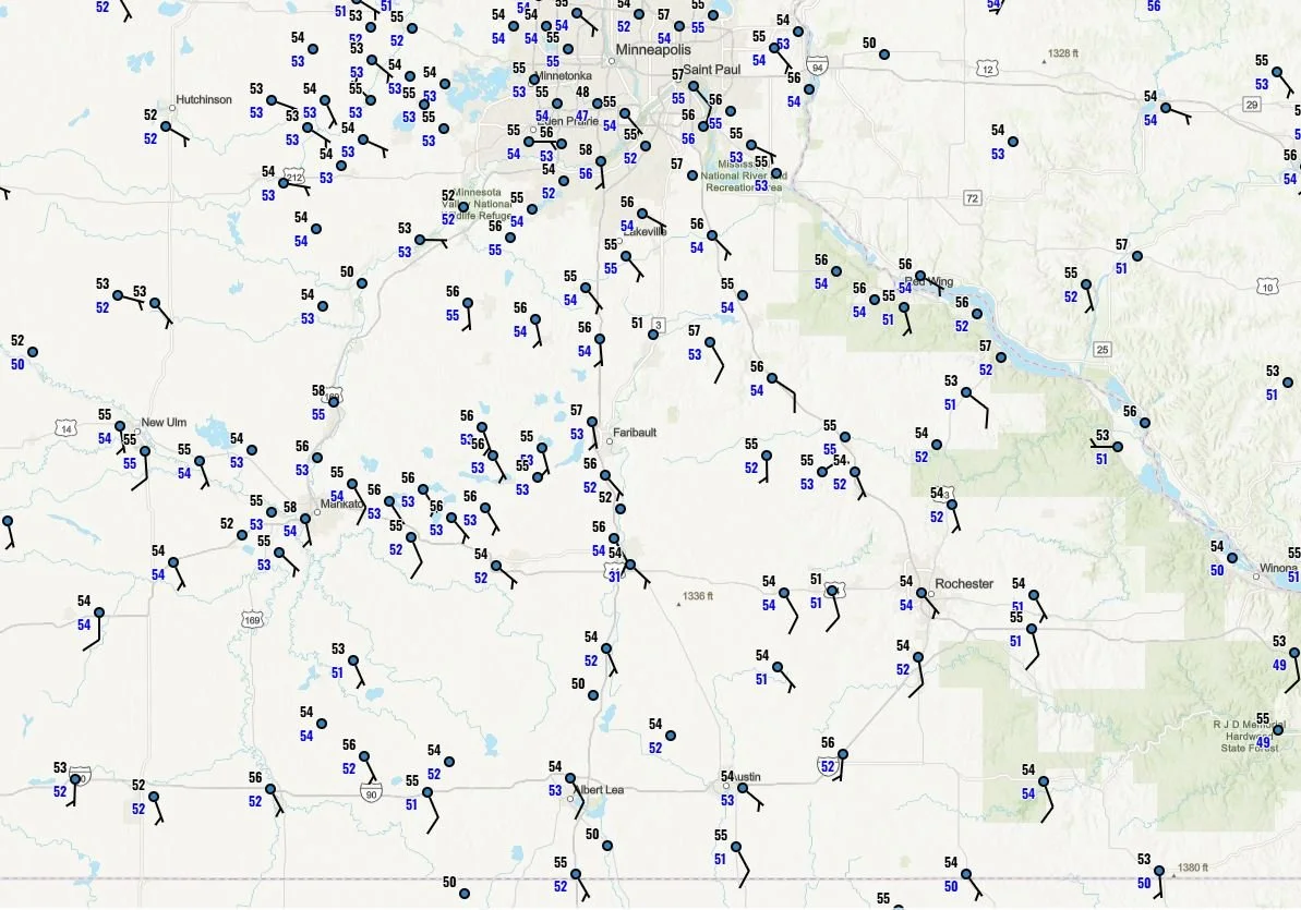
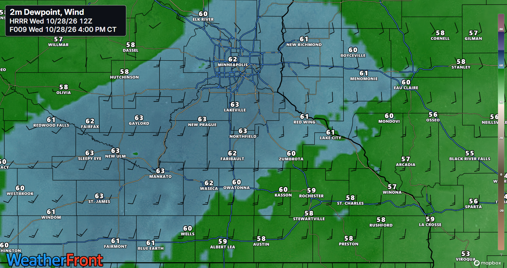
The primary uncertainty involves the amount of moisture and surface heating available. Morning observations indicate that low-level moisture remains limited across the region. The observations I have provided below as of 9 AM show most areas have dew points (blue numbers) sitting around 52-56°F. Air temperatures are in black. With temperature and dew point values as close as they are, there is no surprise there is patchy fog across the region this morning. However, strengthening southerly winds ahead of the approaching weather system should transport warmer, more humid air northward into southern Minnesota.
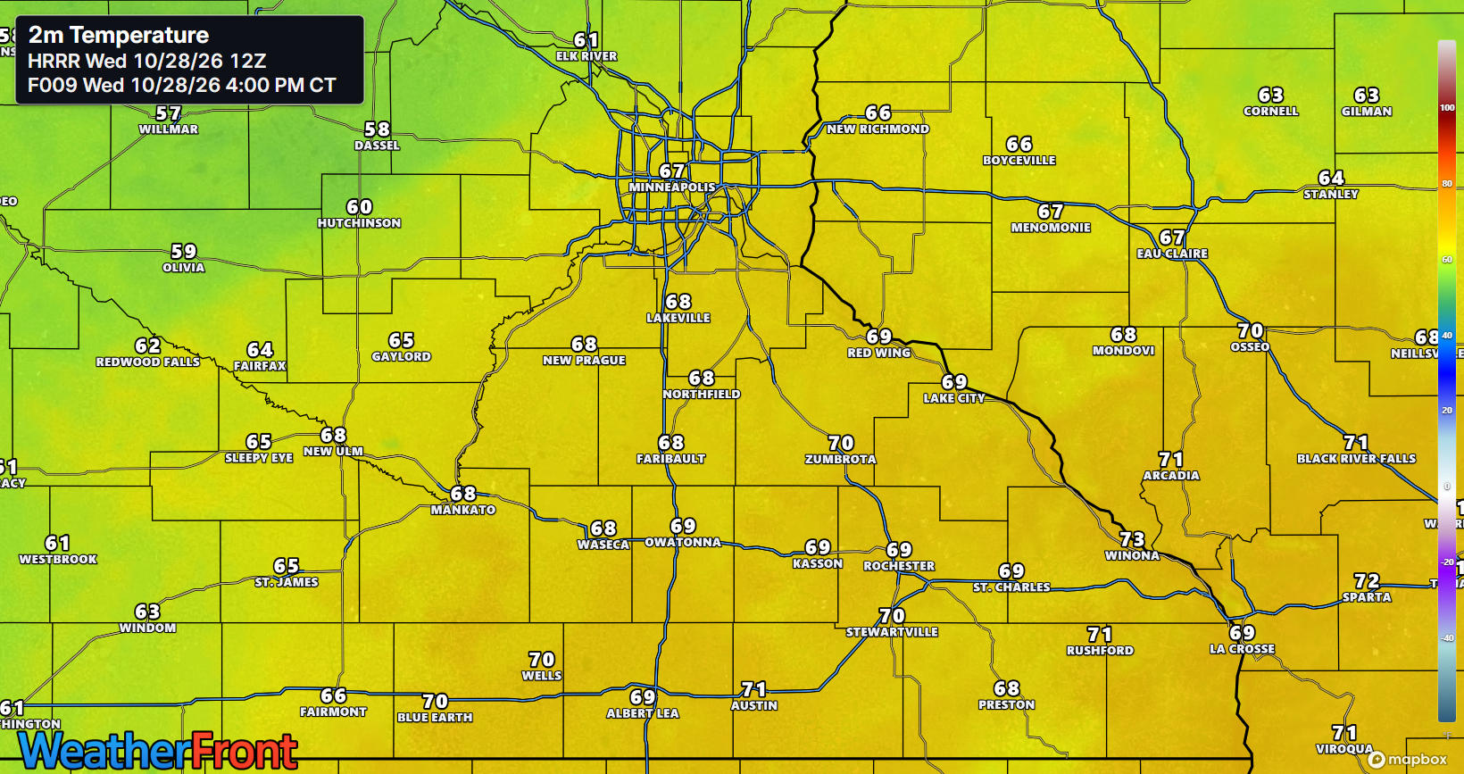
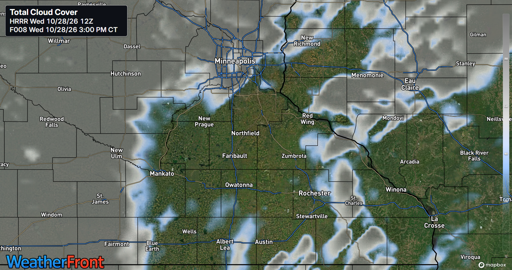
Dew points could climb into the 50s and potentially approach 60 degrees in some locations, as shown in the 12Z HRRR model guidance below. The 12Z HRRR run shows a good swath of the Twin Cities metro reaching dew points around 60-63F around 4 PM, just ahead of the cold front, as shown by the guidance from Elk River to Redwood Falls around 4 PM. Guidance suggests dew points will stay above 60F through the cold front's arrival. The 12Z HRRR guidance also shows temperatures peaking around 68-70 F between 3-4 PM, likely thanks to the clearing that occurs by mid to late morning through about 3-4 PM.
That increase in moisture, combined with daytime heating, may provide just enough instability for thunderstorms to develop near the surface. Forecast moisture levels may be only marginally sufficient to support surface-based storms. If moisture fails to increase as expected, or if cloud cover limits heating, the severe weather threat could drop substantially.
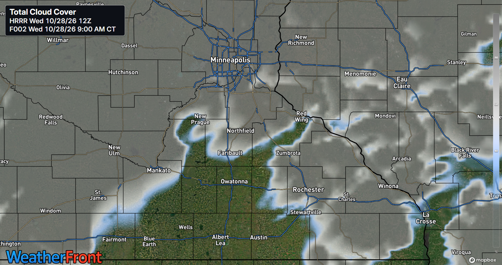
Cloud Cover Could Make or Break Wednesday's Severe Weather Threat
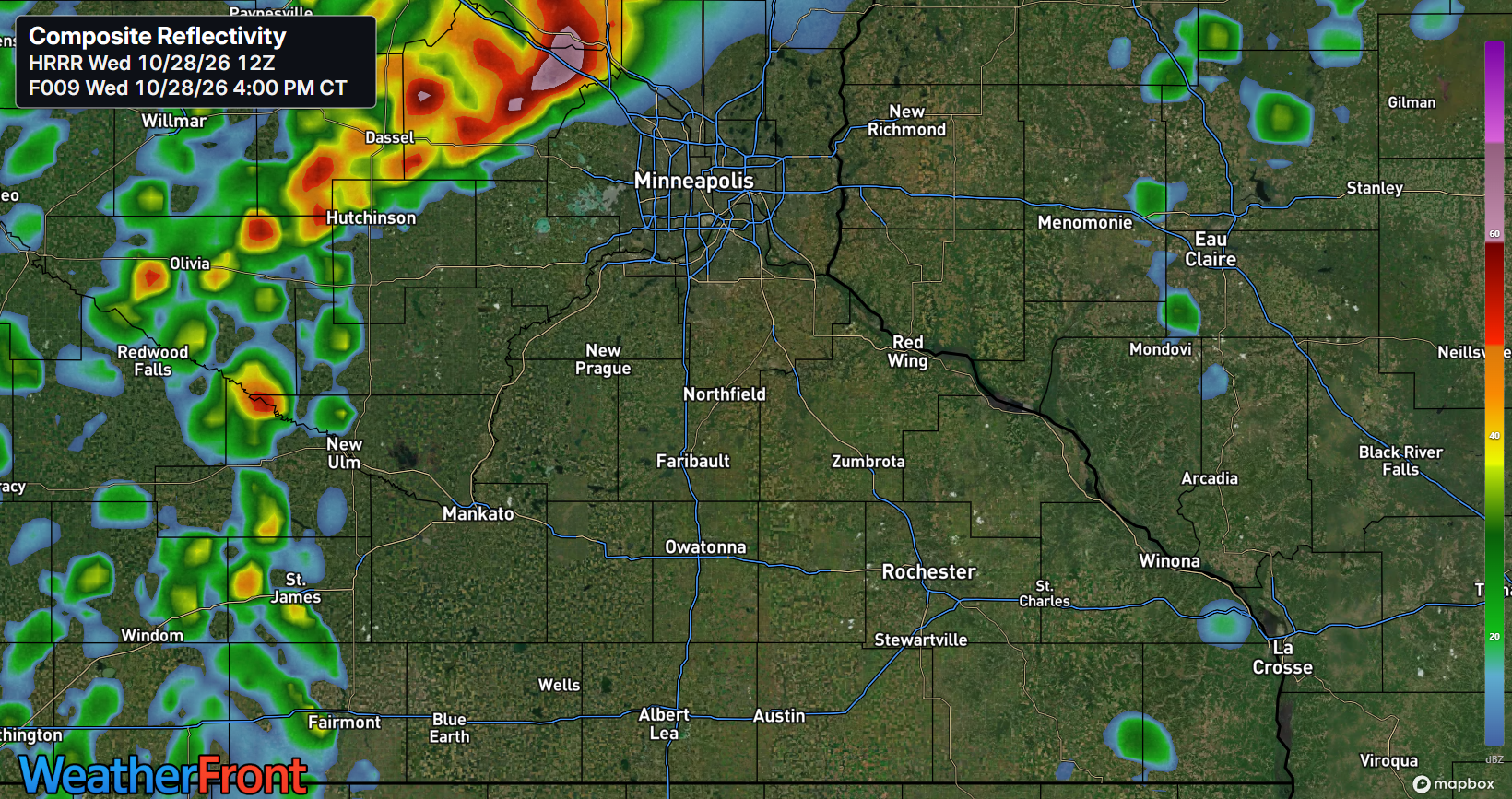
One of the most important factors to monitor Wednesday will be how much sunshine develops across Minnesota before thunderstorms arrive. Persistent cloud cover could prevent temperatures from warming sufficiently, limiting the instability available for thunderstorms. On the other hand, breaks in the clouds during the late morning and early afternoon could allow temperatures to rise and increase the energy available for storm development. The 12Z HRRR model suggests we do see that break across the South Metro, per the two images above.
Afternoon temperatures are forecast to climb through the 60s and into the lower 70s, with the warmest conditions generally expected near and southeast of the Minnesota River. These temperatures are above normal for late October. As warmer and more humid air moves into the region, an approaching upper-level disturbance and surface cold front will provide the lift necessary to initiate thunderstorms.
However, several factors could prevent the severe weather ingredients from coming together, including insufficient daytime heating, limited moisture, poor timing of the frontal passage or atmospheric instability remaining too weak. There is again a chance that today (Wednesday) could be a situation where the favorable ingredients never fully align, resulting in a less significant severe weather event than the wind profiles might otherwise suggest.
This uncertainty is why the severe weather threat is considered highly conditional, even with the upgrade to a Slight Risk.
When Could Thunderstorms Reach the Twin Cities?
The latest forecast guidance indicates that rain and thunderstorms could develop across western Minnesota during the early afternoon before moving eastward toward the Twin Cities and western Wisconsin.
The approaching weather system will feature a strengthening area of low pressure moving across the eastern Dakotas, accompanied by warm and cold fronts. As these features advance eastward, increasing moisture, strong wind shear, and atmospheric lift will support a broad area of showers with embedded thunderstorms.
The most favorable window for severe thunderstorms is expected during the mid-to-late afternoon and early evening.
Wednesday's anticipated timeline (CDT):
Late morning to early afternoon (11 a.m.–2 p.m.): Warmer, more humid air continues moving northward. Showers and thunderstorms may begin developing across western Minnesota, with some earlier precipitation possible around the metro.
Early to mid-afternoon (2–4 p.m.): Showers and thunderstorms spread eastward. Increasing instability and strong wind shear could allow some storms to become better organized.
Mid-to-late afternoon (3–6 p.m.): A potentially important window for isolated tornado development, especially if discrete supercells form across eastern Minnesota and western Wisconsin.
Late afternoon through early evening (4–8 p.m.): The broader period for potentially intense thunderstorms from central Minnesota into northwestern Wisconsin. Large hail, damaging winds, and isolated tornadoes remain possible.
Evening (after 8 p.m.): Thunderstorms continue moving eastward into Wisconsin, with the severe weather threat gradually shifting away from the Twin Cities.
These time windows are approximate and may overlap. They are not a guarantee that storms will affect a particular community during each period. The cold front is expected to advance well into Wisconsin later Wednesday evening, with precipitation exiting its Minnesota and western Wisconsin forecast area before midnight.
Residents should monitor forecast updates throughout the day, as relatively small changes in storm timing, moisture, and cloud cover could significantly influence the severe weather threat.
Cooler, Drier Weather Returns Thursday
Following Wednesday's potentially active weather, a cold front will move east of the region, bringing cooler, drier, and more stable conditions to Minnesota. High pressure is expected to build into the Upper Midwest on Thursday, bringing improving conditions and potentially plentiful sunshine.
High temperatures Thursday are forecast to range from the 50s into the lower 60s, noticeably cooler than Wednesday's readings. The arrival of drier air should also reduce humidity and eliminate the severe weather threat associated with Wednesday's system.
Additional Rain Chances Later This Week
Although Thursday is expected to be relatively quiet, another weather system could bring additional precipitation chances to portions of Minnesota later in the week and into the weekend. A frontal boundary across the central Plains may shift northward somewhat Friday into Saturday. However, the latest forecast suggests that the boundary may not advance as far north as previously anticipated.
As a result, rain chances for Saturday have decreased, with scattered showers now appearing more likely across southern Minnesota rather than throughout the Twin Cities metropolitan area. Temperatures are expected to remain generally above seasonal averages into early next week, although Thursday will be cooler following Wednesday's cold frontal passage.
Stay Weather Aware!
With the Twin Cities now included in a Slight Risk for severe thunderstorms, residents should remain weather aware throughout Wednesday afternoon and evening. Although widespread severe weather is not guaranteed, strong wind shear, increasing moisture, and an approaching cold front could support a few storms capable of producing tornadoes, large hail, and damaging winds.
The key factor will be whether enough instability develops for thunderstorms to become surface-based and organized. If clouds persist and temperatures remain cooler than anticipated, the severe weather threat could be limited or fail to materialize. However, if breaks in the clouds allow additional warming and storms develop in the favorable wind environment, isolated severe thunderstorms could develop relatively quickly.
Have multiple reliable ways to receive severe weather warnings, including Wireless Emergency Alerts, NOAA Weather Radio, and trusted weather applications. Anyone outdoors during the afternoon and evening should be prepared to move indoors if thunderstorms approach. If a tornado warning is issued, seek shelter immediately in a basement or small interior room on the lowest floor of a sturdy building, away from windows.
Limitless Media News will continue monitoring Wednesday's severe weather threat across the Twin Cities, Dakota County, surrounding communities, and western Wisconsin, providing updates as additional information becomes available.
Written By: Meteorologist Will Wight
