
Published: October 24, 2026
TWIN CITIES, MINNESOTA: We will see one more unusually warm day today, Saturday, October 24, 2026, before a passing cold front brings cooler temperatures and several opportunities for rainfall through the middle of next week.
Temperatures are expected to climb into the lower to mid-70s across portions of eastern and southeastern Minnesota this afternoon, well above normal for late October. However, the warmth will be short-lived as a cold front moves southeast across Minnesota, bringing scattered showers and a noticeable drop in temperatures by Sunday.
The unsettled weather pattern is expected to continue into the upcoming workweek, with multiple storm systems moving through the Upper Midwest. While the Twin Cities could see periods of rain, the heaviest rainfall is currently forecast across western Minnesota, where some communities could receive more than an inch of precipitation.
Rest of Saturday: Unseasonably Warm Temperatures Before Cold Front Arrives
Saturday began with unusually mild conditions across much of Minnesota and western Wisconsin, as breezy southeasterly winds and widespread cloud cover kept temperatures from falling significantly overnight, with many places sitting in the upper 50s to lower 60s across much of the region this morning. Those overnight temperatures are approximately five to seven degrees warmer than the normal daytime highs for this time of year.
The warmth is associated with a strengthening low-pressure system over south-central Canada. As the system moves northeast, an accompanying cold front will advance southeastward across Minnesota throughout the day today. The front's timing will play an important role in afternoon temperatures, with parts of Western Minnesota, where the front is expected to arrive earlier, experiencing more limited daytime warming and highs generally reaching the lower 60s. However, locations farther east, including much of the Twin Cities metro area, southeastern Minnesota, and western Wisconsin, will have a better opportunity to warm before the front arrives.
Temperatures will reach the lower to mid-70s in areas that remain ahead of the front through midday, aided by filtered sunshine and continued warm air moving into the region. This could create a temperature difference of more than 10 degrees between western Minnesota and western Wisconsin Saturday afternoon.
Scattered Showers Possible Saturday Afternoon and Evening
Rain showers that were moving through portions of Minnesota and Wisconsin early this morning are expected to continue shifting eastward as the cold front advances, with additional scattered showers expected to develop across central Minnesota. A few rumbles of thunder are possible near the approaching cold front and within any stronger cells that develop.
The main band of showers is forecast to move toward the I-35 corridor by this afternoon, then continue eastward into the evening. For the Twin Cities, including Minneapolis, St. Paul, Bloomington, Burnsville, Eagan, Apple Valley, Lakeville, and surrounding communities, this means rain could develop or move through parts of the area during the afternoon and evening. Rainfall amounts are expected to remain relatively light.
Western Minnesota could receive isolated totals ranging from one-tenth to one-quarter of an inch, while amounts should generally decrease farther east. Portions of southeastern Minnesota and western Wisconsin may receive only a few hundredths of an inch. As the front passes, winds will shift to the northwest, allowing cooler air to spread across the region.
Sunday: Temperatures Return to Seasonal Levels
The arrival of cooler air behind Saturday's cold front will bring a noticeable change in conditions Sunday, October 25. After Saturday's potential highs in the 70s, temperatures across much of the Twin Cities metro are expected to reach only the lower to mid-50s Sunday afternoon.
That represents a temperature drop of approximately 15 to 20 degrees in some locations, bringing conditions closer to what residents would normally expect during the final week of October. Sunday is also expected to feature mostly cloudy skies, with the possibility of a few isolated rain showers.
Although widespread or significant rainfall is not currently anticipated Sunday, the combination of cloud cover, cooler temperatures, and occasional showers will make conditions feel considerably different from Saturday's warmth.
Monday and Tuesday: More Organized Rain System Approaches Minnesota
A more substantial chance of rain is expected to develop early next week as another weather system moves northward through the central Plains. A developing low-pressure system is forecast to track from central Nebraska toward northwestern Minnesota between Monday and Tuesday. This system will draw unusually high amounts of atmospheric moisture northward into the Upper Midwest ahead of its arrival.
The combination of abundant moisture and a developing low-pressure system could support a broad area of moderate to locally heavy rainfall, though the Weather Prediction Center has not yet highlighted any areas of concern for excessive rainfall.
Western Minnesota Could Receive More Than an Inch of Rain
The heaviest precipitation is currently expected along the projected track of the low-pressure system, extending from central Nebraska through eastern South Dakota and into far western Minnesota. Within that corridor, a swath of approximately 1 to 1.5 inches of rainfall is possible. However, rainfall totals are expected to decrease farther east.
For the Twin Cities metro area, the latest forecast supports additional rain chances, but the heaviest rainfall corridor is currently positioned well to the west. The exact track of the developing storm will ultimately determine how much precipitation reaches Minneapolis, St. Paul, and surrounding communities.
Cloud cover and rainfall will also influence temperatures Monday. Much of central and western Minnesota could struggle to climb out of the 40s during the afternoon, particularly where rain persists for extended periods. Temperatures may vary across eastern Minnesota depending on the timing and coverage of precipitation.
Tuesday Into Wednesday: Another Cold Front and Additional Rain Chances
The unsettled weather pattern is expected to continue Tuesday, October 27, and Wednesday, October 28, as another disturbance moves across the northern United States. This system is forecast to strengthen a low-pressure area near the Canadian border, temporarily placing Minnesota on the warmer side of the developing storm.
As a result, temperatures could rebound into the 50s and 60s Tuesday before another cold front moves through the region late Tuesday or early Wednesday. The timing and coverage of precipitation associated with this system remain uncertain, with the current forecast probabilities suggesting a 30% to 50% chance of precipitation early Wednesday, reflecting differences among weather models regarding how quickly the system will move through the region.
Under the current forecast, temperatures could reach the lower to mid-60s Wednesday afternoon after any early-day precipitation moves out. However, these temperatures depend on how quickly this system arrives. A slower-moving system could keep clouds and precipitation over the region longer, limiting daytime heating.
Additional forecast adjustments are likely as the timing and strength of the system become clearer.
Late Next Week: Warmer Weather Could Return Ahead of Halloween
Looking beyond the middle of next week, longer-range weather models are beginning to suggest another potential warming trend across Minnesota heading into Halloween weekend.
The latest forecast suggests a broad area of high pressure, otherwise known as a ridging pattern, is expected to develop over the central United States during the second half of next week. This pattern tends to favor warmer temperatures, although an active stream of winds higher in the atmosphere could still bring occasional opportunities for rain.
Several forecast models are increasingly suggesting temperatures could climb above normal again toward the end of October, with current forecasts already indicating temperatures in the upper 50s late next week, which would be above average for the season. However, if the warmer scenario becomes more consistent in upcoming forecasts, temperatures could climb higher than currently predicted.
For residents planning outdoor activities, neighborhood events, or trick-or-treating on Saturday, October 31st, the early indications of warmer weather are encouraging, although it remains too soon to determine specific Halloween temperatures or whether rain will affect evening activities.
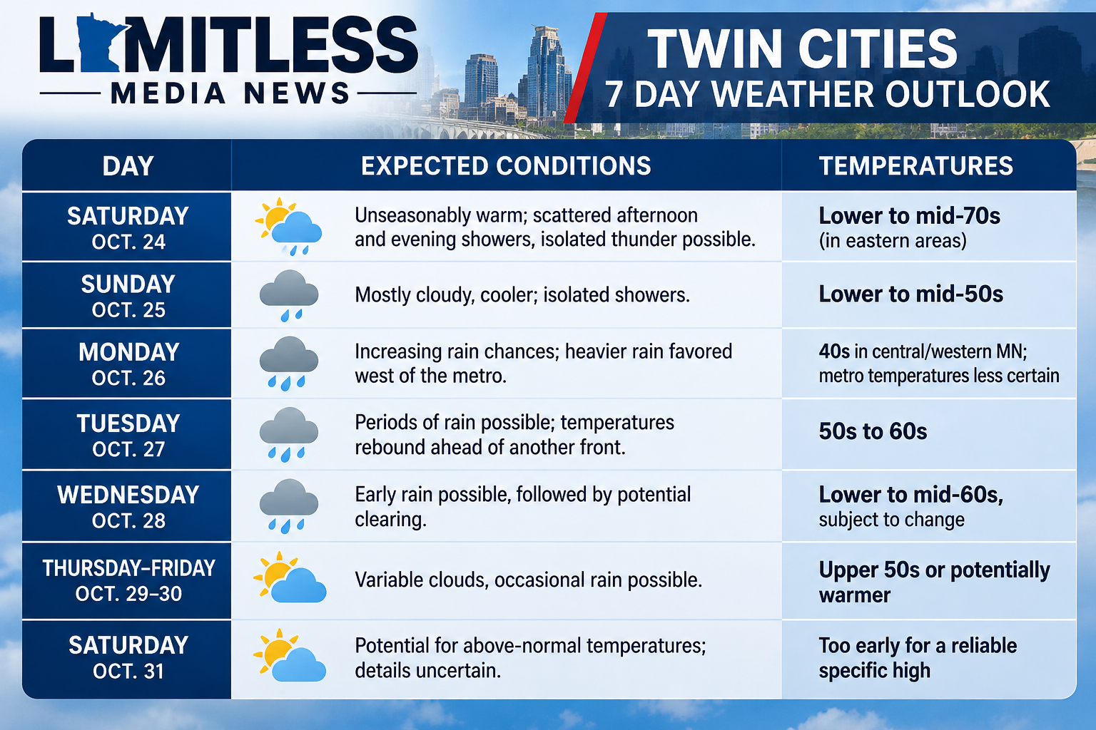
Twin Cities Weather Outlook: October 24–31
The following summarizes the regional forecast trends. Temperatures and precipitation chances may vary by location.
Written By: Meteorologist Will Wight
