
Wintry Mix Expected to Transition to Heavy, Slushy Snow Overnight; Winter Weather Advisory Issued for Parts of the Region
Published: November 17, 2025.
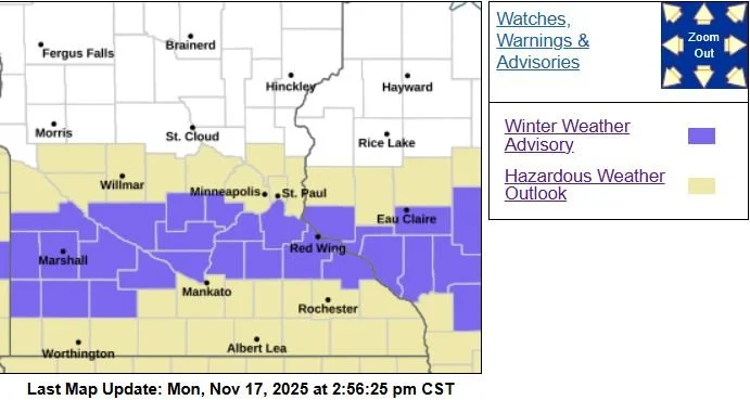
TWIN CITIES, MINNESOTA: A challenging, highly uncertain winter storm is unfolding across southern Minnesota and western Wisconsin tonight into Tuesday morning, with the potential for a narrow band of heavy, rapidly accumulating snow, especially from Redwood Falls through the southern Twin Cities metro to Eau Claire. The National Weather Service Twin Cities has issued a Winter Weather Advisory for portions of southwest, south-central, and the southern Twin Cities metro, highlighting the potential for quick, slushy accumulations.
Winter Weather Advisory in Effect Overnight
The advisory is in effect from midnight to 9 a.m. Tuesday for the following counties: Yellow Medicine, Redwood, Renville, Brown, Nicollet, Sibley, McLeod, Le Sueur, Rice, Carver, Scott, and Dakota counties.
Cities included in the advisory area range from Granite Falls and Redwood Falls to New Ulm, St. Peter, Le Sueur, Faribault, Hutchinson, Chaska, Shakopee, Hastings, and much of the southern Twin Cities metro.
What to expect:
Rain transitioning to a mix of rain and snow overnight
Periods of all snow, which may become heavy at times
Total accumulations up to 3 inches, with locally higher slushy amounts possible
Slippery roads and hazardous travel conditions
Morning commute impacts, especially south of I-94
Surface temperatures around freezing will play a critical role. Even a one-degree swing could determine whether areas see mostly rain or several inches of quickly accumulating wet snow.
Hennepin, Ramsey, and Washington Counties are not under the Winter Weather Advisory at this time due to the tight gradient and cut off, but in later updates, they could be added.
Rain and Snow Develop This Evening — But Precip Type Is on a Knife's Edge
A band of rain is already developing across southern South Dakota, with thunderstorms farther southeast [pictured below]. This band will lift into southern Minnesota this evening, bringing widespread rain that may mix with or change to snow overnight.
The latest model guidance shows that low-level atmospheric temperatures are at or near freezing, 32°F. The forecast for this system is somewhat tricky because a one-degree change could cause the precipitation to fall as all rain or all snow. That means even slight shifts in temperature can drastically change snowfall amounts across the region, which is why some areas could see a good chance of accumulating snow. In contrast, another area, as far south as a county, may see almost none.
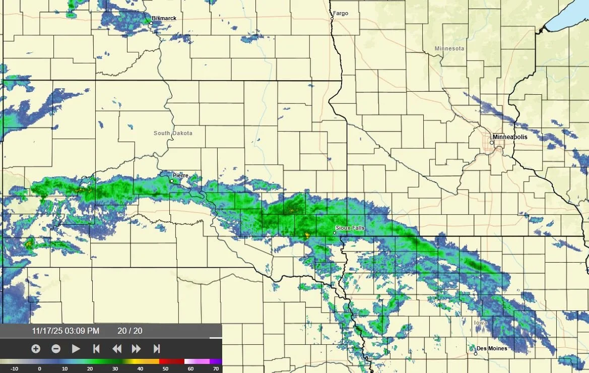
Latest radar from the NWS as of 3:09 PM on November 17, 2025.
Narrow Band of Heavier Snow Likely
Model guidance continues to show a narrow but intense band of heavier precipitation developing overnight across south-central to west-central Wisconsin, with high-resolution guidance indicating a zone of heavier snowfall rates possible within an area we often call the “deformation zone.” The deformation zone is a region within the storm with enhanced lift that supports the development of heavier precipitation. When temperatures are favorable, heavier precipitation can fall as snow. Within this band, 1 to 3 inches of slushy accumulation is expected by Tuesday morning. Based on the latest guidance, though, it appears that the band should set up south of the Twin Cities Metro, likely across far southern Scott and Dakota Counties and points south. Snowfall totals could vary significantly over short distances depending on where the narrow band sets up.
The confidence in where this heavier band sets up is still low, as there continue to be shifts in the track and placement from run to run. As of now, it appears that the best chance of seeing heavier precipitation (rain or snow) lies along a line from Granite Falls to the Twin Cities to Eau Claire and points south. North of that line, little to no precipitation is possible.
Travel Impacts Possible Tuesday Morning
Road impacts will depend on snowfall rates and surface temperatures. Right now road temperatures are sitting around the mid-40s across Dakota County, but if snowfall rates are high enough, it won’t be hard to overcome those warmer road temperatures. This is especially true on elevated surfaces and bridges, where accumulation would likely occur first. Areas under the heavier band may experience slushy, slick conditions on Tuesday morning. Again, elevated and untreated surfaces will be most prone to accumulating slush.
Areas north of I-94, including much of the Twin Cities, are likely to remain on the northern edge of the system and could see little to no accumulation.
What’s Next
The wintry mix will taper off from west to east by mid Tuesday morning to early Tuesday afternoon as the system pulls away.
Limitless Media News will continue to monitor the storm and provide updates as new forecasts and conditions develop.

Latest snowfall map from the NWS Twin Cities as of 3:15 PM on November 17, 2025.