
Winter Storm Warning Issued for Twin Cities Metro for Heavy Snow, Strong Winds, and Possible Blizzard Conditions
Provided by the NWS Twin Cities.
Published: November 25, 2025.
TWIN CITIES, MINNESOTA: The National Weather Service (NWS) Twin Cities has issued a Winter Storm Warning for parts of Minnesota and western Wisconsin, advising residents to prepare for a rapidly intensifying winter storm expected to bring heavy snow, strong winds, and potentially dangerous travel conditions from Tuesday afternoon through Wednesday morning.
A potent storm system will track across the Upper Midwest today, pulling colder air into the region and changing rain over to snow from west to east. Forecasters say the transition will occur this afternoon and evening, with the heaviest snowfall expected overnight.
Heavy Snowfall and Rapid Deterioration in Conditions
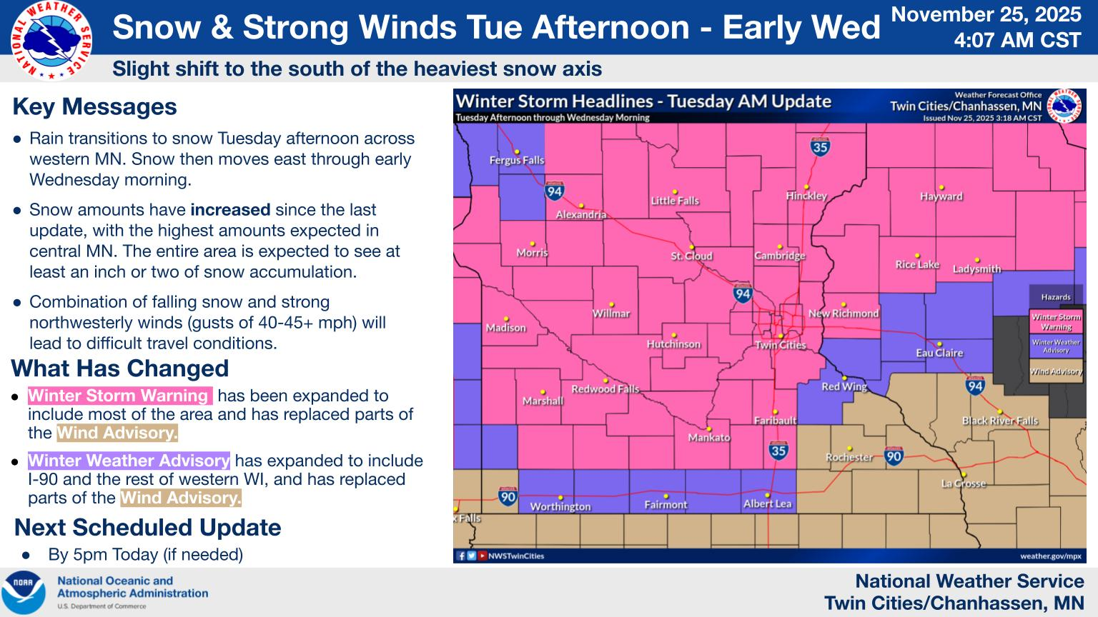
Periods of heavy snow with rates of 1 inch per hour or more are expected, particularly across central Minnesota and northwest Wisconsin, including the Twin Cities metro. These areas could see 4 to 7 inches, while southern Minnesota is forecast to receive 2 to 4 inches.
As the storm intensifies, northwest winds gusting up to 45 mph will develop later today and continue through the night. The combination of falling snow and strong winds may create blizzard-like conditions at times, with visibility dropping to a quarter mile or less. Widespread blowing and drifting snow will also make travel difficult.


Warnings and Advisories
Multiple winter headlines are in effect across the region:
Winter Storm Warnings
6 PM Tuesday to 9 AM Wednesday:
Hennepin, Anoka, Carver, Scott Counties9 PM Tuesday to 9 AM Wednesday:
Dakota, Ramsey, Washington, Rice, Steele, and Waseca Counties (MN)
Barron, Rusk, and St. Croix Counties (WI)
Within these areas:
Heavy snow and blowing snow
Total accumulations of 2–4 inches across southern Minnesota
4–7 inches across northwest Wisconsin
Wind gusts up to 45 mph
These conditions are likely to create hazardous travel conditions, especially on Wednesday morning. Tree damage is also possible due to the strong winds.
Winter Weather Advisories
Far southern Minnesota and parts of west-central Wisconsin remain under advisories for lighter snow accumulations and potentially slick travel.
Travel Impacts and Safety
Road conditions are expected to worsen quickly after sunset as temperatures fall and snow intensifies.
Drivers are urged to:
Avoid unnecessary travel during the height of the storm.
Carry an emergency kit including a flashlight, food, and water.
Check the latest road conditions before heading out.
Minnesota travelers can access updated information at 511mn.org, and Wisconsin travelers can use 511wi.gov.
The storm is expected to move out on Wednesday morning, with conditions gradually improving through the day.
Limitless Media News will continue to monitor the storm and provide updates as conditions evolve.