
Winter Storm to Bring Several Inches of Snow to Twin Cities Metro Friday Night Through Saturday


Published: November 28, 2025.
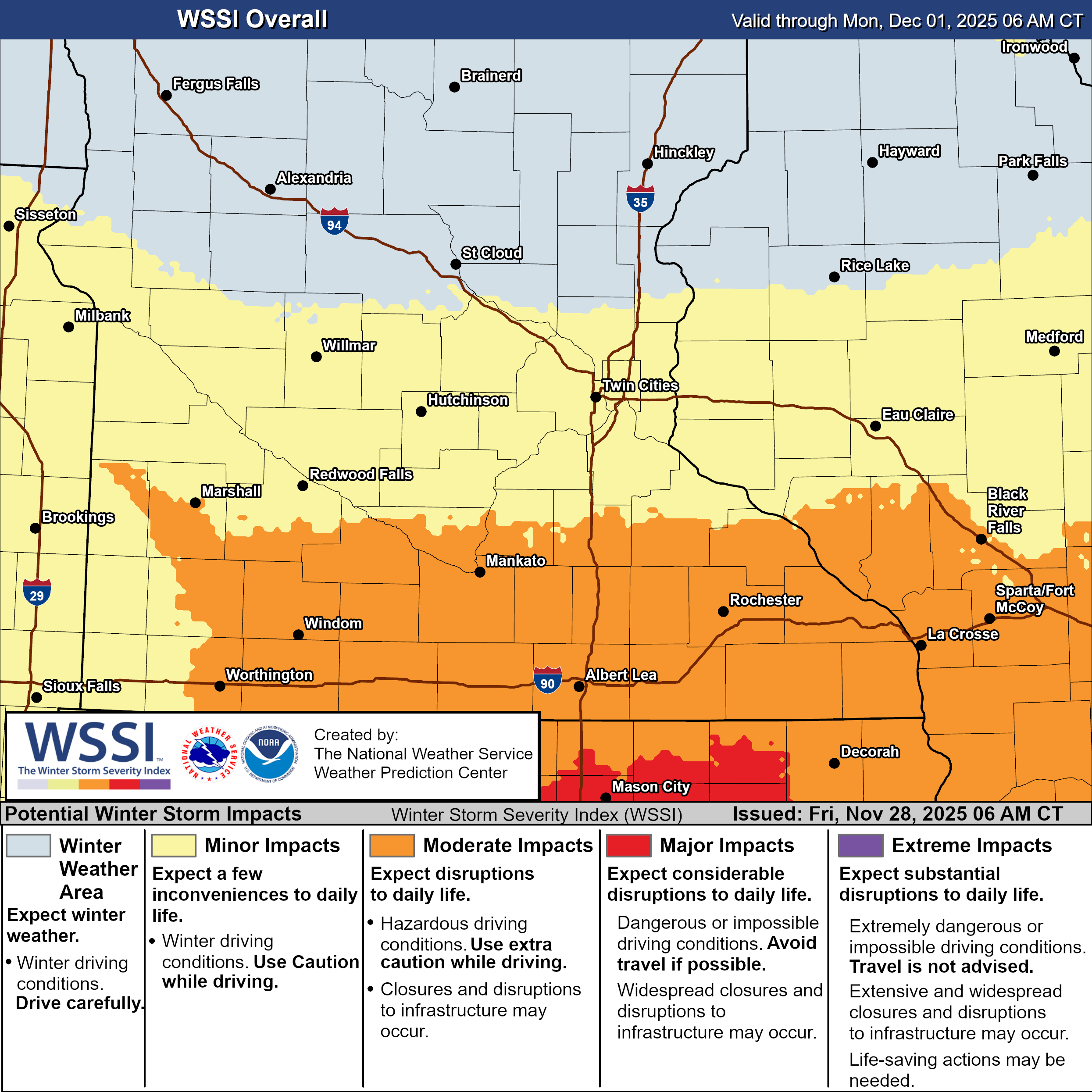
TWIN CITIES, MINNESOTA: A winter storm is set to impact much of Minnesota and western Wisconsin beginning Friday evening, with the Twin Cities metro area under a Winter Weather Advisory from midnight tonight through midnight Saturday. The latest guidance shows this system will bring steady, long-duration snowfall, creating slippery road conditions and potential travel delays through the first half of the weekend, affecting holiday travelers.
While the heaviest snow is expected across southern Minnesota, the Twin Cities will still see meaningful accumulations, with a sharp north-to-south gradient across the metro. Current projections suggest 3 to 4 inches in the northern metro and 5 to 6 inches in the southern metro by the time snow tapers late Saturday night.
Storm Overview: Long Duration, Widespread Snow
Light snow will first enter southwestern Minnesota this evening, then spread east overnight, arriving in the far western Twin Cities metro by around 10 PM this evening (Friday). By early Saturday, the storm becomes fully organized, sending steady snow across all of southern Minnesota, including the Twin Cities, and into western Wisconsin. The current setup for this system won’t necessarily bring heavy snowfall, but rather a long duration of steady snow accumulation throughout the day on Saturday.
Snow will gradually diminish from west to east Saturday evening, ending overnight.
Metro Impacts: Steady Snowfall and Slippery Roads
For the Twin Cities counties, Hennepin, Ramsey, Dakota, Scott, Washington, Carver, Wright, McLeod, Meeker, and Kandiyohi, the National Weather Service has 3 to 6 inches of snow expected, with higher amounts possible south of the river.
Key Metro Impacts:
3–4" northern metro, including areas toward Anoka and northern Ramsey County.
5–6" southern metro, including Dakota, Scott, and southern Hennepin counties.
Prolonged light to moderate snowfall is expected on Saturday.
Slippery travel, especially Saturday morning through afternoon.
Limited blowing snow, as winds remain under 20 mph.
Hazardous driving conditions, particularly during periods of steady accumulation.
While snowfall rates are not expected to be particularly intense, the long duration increases the potential for roads to become snow-covered and slick. For those traveling back from the holidays, if you can, push your travel to Sunday. If not, allow extra time for travel, reduce speed, and check road conditions at 511mn.org.
Provided by the NWS Twin Cities.
Heaviest Snowfall South of the Metro
The most significant impacts remain focused across southern Minnesota, where a band of 7 to 10 inches is expected Saturday, especially along and south of the I-90 corridor.
Because forecast totals have increased in recent updates, the Weather Service expanded its Winter Storm Warning northward to include Redwood, Nicollet, Le Sueur, Rice, Wabasha, and Goodhue counties. These areas will be closer to the storm's core, where persistent snowfall will accumulate quickly.
Travel across southeastern Minnesota, including Mankato, Owatonna, Albert Lea, and Rochester, will likely deteriorate rapidly on Saturday.
Western Wisconsin: Advisory Expanded Eastward
Snow will extend into Wisconsin late Friday night and continue through Saturday, prompting the expansion of the Winter Weather Advisory to include counties from St. Croix to Chippewa and southward.
Western Wisconsin can expect 3 to 6 inches, with lighter amounts north toward Bloomer and heavier amounts south and west toward the Minnesota border.
Cold Air Follows the Storm
As precipitation clears out Saturday night, behind the departing system, a Canadian high pressure system will fill in, bringing a shot of bitterly cold air to the region. On Sunday and Monday, highs are forecast to reach only the teens, with overnight lows in the single digits, above or below zero. Wind chills are predicted to be below zero both mornings.
While we are progged to see a brief warmup by Wednesday, it will be short-lived, as another cold front is forecast to return temperatures to the teens later in the week. While this is supposed to be a dry frontal passage, we can’t rule out maybe seeing a flurry out of it. Guidance is hinting at another clipper that could bring another round of light snow late Friday into Saturday. It’s a little early to get the snowfall totals nailed down, but another 1-3” could definitely be possible for the Twin Cities metro!