
WINTER WEATHER ADVISORY: Mixed Precipitation, Heavy Snow Band, and Strong Winds Expected Tuesday Afternoon Through Early Wednesday


Published: December 8, 2025.
TWIN CITIES, MINNESOTA: A fast-moving but powerful clipper system is forecast to bring a messy mix of snow, rain, and ice, and potentially a narrow corridor of heavy accumulating snow, to much of central and southern Minnesota from Tuesday afternoon through early Wednesday morning.
The National Weather Service has issued a Winter Weather Advisory from 3 p.m. Tuesday to 6 a.m. Wednesday for Carver, Dakota, Hennepin, Scott, Rice, Steele, and Goodhue counties. Winter Storm Warnings are in place north of the Twin Cities metro, across an area where 4-7 inches, with locally higher amounts nearing 8 inches and strong wind gusts up to 40 mph are possible.
Slippery roads, reduced visibility, scattered power outages, and a difficult Tuesday evening commute are possible as the storm intensifies.
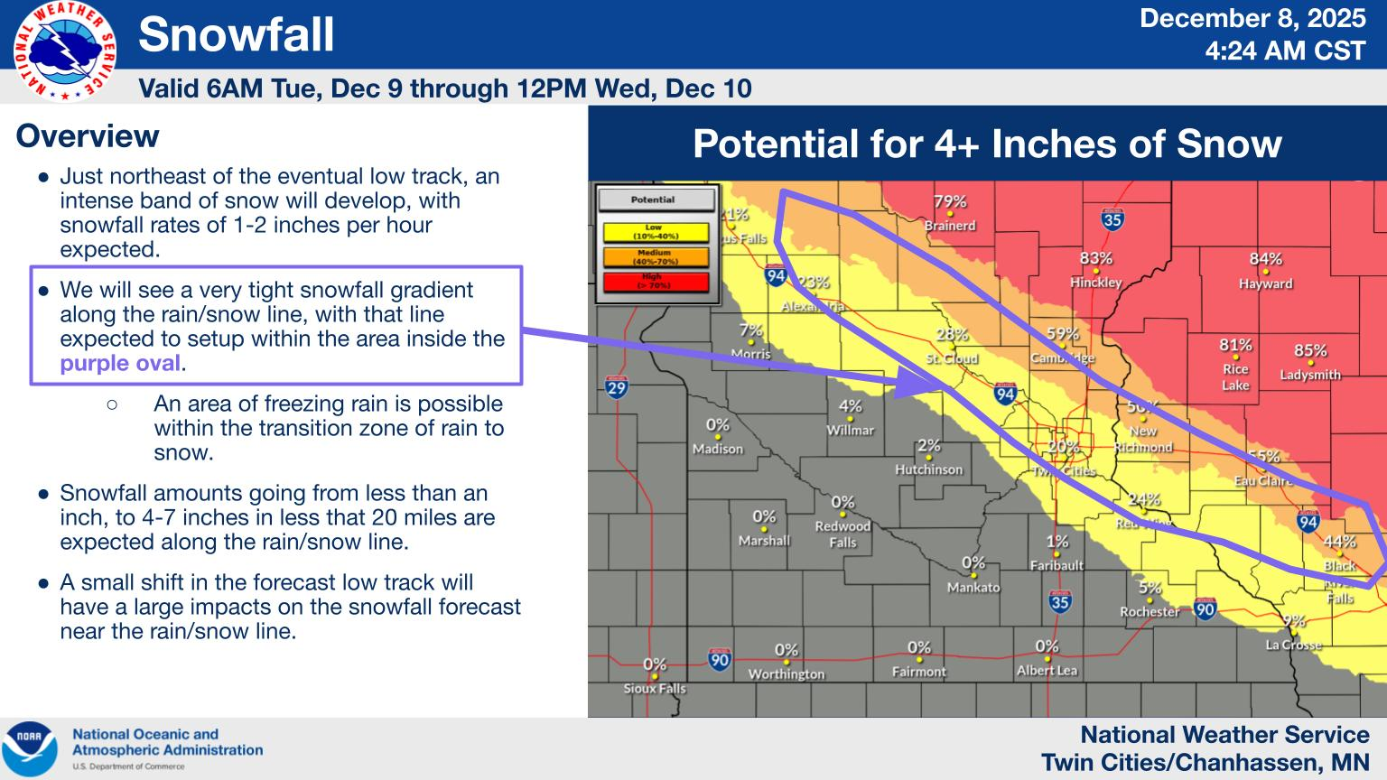
Twin Cities Metro Forecast Overview
Snowfall: Widespread totals of 2 to 5 inches in advisory areas, with the potential for a narrow heavy snow band of 5 to 8 inches setting up northeast of the storm’s low track (north of the Twin Cities Metro).
Ice: A light glaze of ice is possible during the first 2–4 hours of precipitation onset on Tuesday, especially where freezing rain briefly mixes in.
Wind: Gusts of 40 to 50 mph are possible Tuesday evening, especially south of I-94. These winds could bring down tree branches and sharply reduce visibility.
Timing:
Early Tuesday afternoon: Snow begins in central Minnesota, west and northwest of the Twin Cities metro.
Late afternoon into evening: Snow and mixed precipitation will spread southeast through the Twin Cities metro and into western Wisconsin.
Overnight: Heavy snow band develops northeast of the low track, while strong winds increase.
Wednesday morning: Snow tapers from west to east.
Because the storm is pulling in both warm and cold air, the exact track of the low will determine whether locations see mostly rain, snow, or a wintry mix.
Rain/Snow Line Could Cut Directly Across the Twin Cities
Current model trends favor a low track from Fargo toward the Twin Cities and into western Wisconsin. Still, slight shifts in the track, as little as 20 to 30 miles, will have significant implications for the precipitation type and precipitation totals. For example:
Southwest of the low track: Rain or a rain/snow mix, with lower snowfall totals would be favored.
Along the low track, periods of mixed precipitation are likely.
Just northeast of the low track: There will be the potential for very intense snowfall rates of 1–2 inches per hour.
Depending on the final track, the heavy snow band could land anywhere from the Twin Cities metro to a corridor extending from Little Falls to Taylors Falls to Chippewa Falls.
Hazards & Travel Impacts
Road Conditions: Expect slippery highways, especially during the evening commute on Tuesday, when heavy snow and freezing drizzle may overlap.
Visibility: Whiteout-type conditions may occur at times under the heavy snow bands.
Wind: Gusts of 45–50 mph could cause isolated tree damage and blowing snow.
Power: A light glaze of ice combined with strong winds could cause scattered outages, especially in southern Minnesota.
Motorists are urged to slow down, allow extra time, and check road conditions at 511mn.org.

Early Morning Snow Today Just the Beginning
Ahead of the main system, an initial band of “warm-air advection” snow, currently across western Minnesota, is gradually working toward the Twin Cities metro, and is forecast to arrive around 5-6 PM. If this activity reaches the ground, upwards of a dusting to 1” is possible across the metro, with a dusting to 2 inches in areas north of the Twin Cities metro, from Staples to Mora and into northern Wisconsin. The dry conditions at the surface could hinder its ability actually to reach the surface.
Dangerous Cold Returns Later This Week
Following the storm, cold air is forecast to surge across the region from the north-northwest, causing temperatures to plunge again:
Highs: Struggling to reach 10°F Friday through Sunday
Lows: Single digits to teens below zero
Wind Chills:
–25°F to –35°F likely Friday night into Saturday
The National Weather Service is hinting that Extreme Cold Alerts (likely an Advisory) may be issued due to these cold conditions.
Guidance shows several weak systems may bring an additional quick-hitting 0.5–2 inch snow event Thursday through Saturday, before we see a slight shift in the pattern early next week, which could finally bring a break from the cold and the near-daily snowfall.
Preparation & Safety Tips
Allow extra travel time on Tuesday afternoon and evening
Keep an emergency kit in your vehicle
Secure outdoor holiday decorations before strong winds arrive
Prepare for potential isolated power outages
Stay updated through NWS Twin Cities and 511mn.org