
First Flakes Possible This Weekend in the Twin Cities as Clipper System Approaches
Published: November 6, 2025.
TWIN CITIES, MINNESOTA: The Twin Cities could see the first flakes of the 2025–2026 winter season this weekend as a fast-moving clipper system slides in from the northwest, bringing a mix of rain and snow to much of southern Minnesota.
Forecast Overview
We’re monitoring an Alberta clipper that is expected to reach the region late Saturday into early Sunday. Current forecasts suggest precipitation will begin as rain before transitioning to snow as colder air wraps in behind the system and across the region.
The latest model guidance shows a mix of rain and snow for much of the Twin Cities area, with the potential for around 1 inch of slushy accumulation farther southwest, particularly across southwestern Minnesota. Most places within the Twin Cities shouldn’t see any accumulation, just flurries, according to the latest guidance.
Travel and Temperature Impacts
A few higher-resolution models hint that, along the frontal boundary, strong bands of snow could develop. If these develop, narrow corridors of heavier snow could briefly enhance accumulations, though this threat is primarily in far southern and southwestern Minnesota. Confidence remains low in this solution until later this week.
Another factor in this system's snowfall potential is the track of the surface low, which remains uncertain between the various guidance. A northern track would favor more rain and limited snow for the Twin Cities. In contrast, a southern track would increase the potential for accumulating snow across parts of the far southern metro and into southwestern Minnesota.
No matter the track, a strong surge of colder air is forecast to work across the region behind this system. This could result in any wet or slushy surfaces becoming slick late Saturday night into Sunday morning, especially in southwestern Minnesota, where the best chances for minor accumulations are most likely.
For the Twin Cities metro, light snow or flurries may mix in at times Saturday, particularly west and south of the Metro area, but again, no accumulation is expected. The residents in far western and southern Carver and Scott counties may be lucky enough to see a very light, measurable snowfall. If that were to occur, it would probably be on grassy or elevated surfaces.
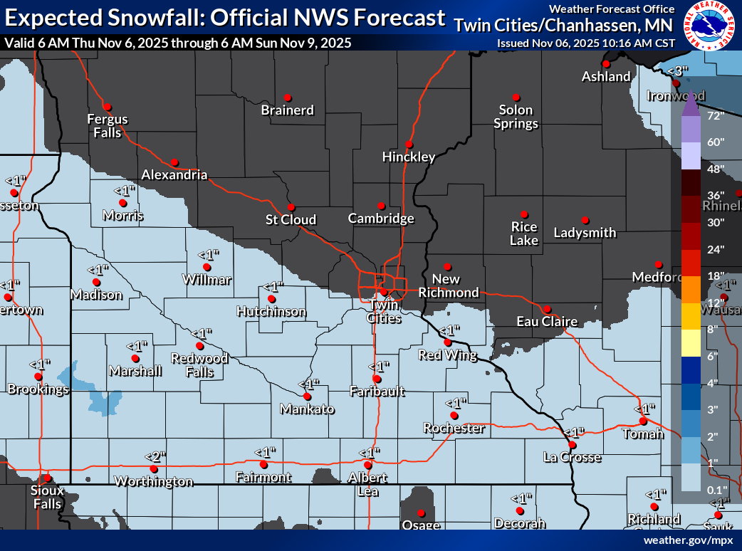
Latest snowfall map from the NWS Twin Cities as of 11 AM on November 6, 2025.
Looking Ahead
The weekend system serves as a reminder that the winter weather season is quickly approaching. We will continue to monitor the latest model trends and provide updates if there are any significant changes!