
Twin Cities Snowfall Running Well Above Normal After Lagging Far Behind Last Winter, With Wetter Pattern Favored Into Early 2026
Published: December 30, 2025.
TWIN CITIES, MINNESOTA: After a winter that struggled to gain traction last year, snowfall across the Twin Cities metro has made a notable comeback so far this season, with December 2025 finishing well above normal, and long-range outlooks suggesting an active pattern could continue into early 2026.
According to Twin Cities Almanac data as of 12:00 a.m. Tuesday, December 30, the metro has already surpassed typical late-December snowfall totals, a sharp contrast to the below-normal winter conditions observed at this time last year.
December 2025 vs. December 2024: A Stark Contrast
So far this month, the Twin Cities have received 14.8 inches of snow, nearly four inches above the December normal of 11.0 inches.
At the same point last year, December 2024 had produced only 7.0 inches of snow, placing the metro well below normal heading into the New Year. Snowfall this December is therefore more than double what was observed at this time in 2024.
Snowpack has also been more persistent. The maximum snow depth reached 10 inches this month, compared to just 5 inches last year, reflecting a colder, more sustained winter pattern that has allowed snow to accumulate rather than repeatedly melting.
Season-to-Date Snowfall: Above Normal After a Slow Start Last Winter
Looking at the broader season, snowfall since July 1, 2025, totals 22.6 inches, about 4 inches above the seasonal normal of 18.6 inches for late December.
By comparison, only 8.1 inches of snow had fallen by this time in 2024, putting last winter far behind schedule and contributing to one of the metro’s slowest snowfall starts in recent years. In practical terms, the Twin Cities have already received nearly three times as much snow this season as at the same point last year.
The season’s maximum snow depth of 10 inches again doubles what had been observed by late December 2024.
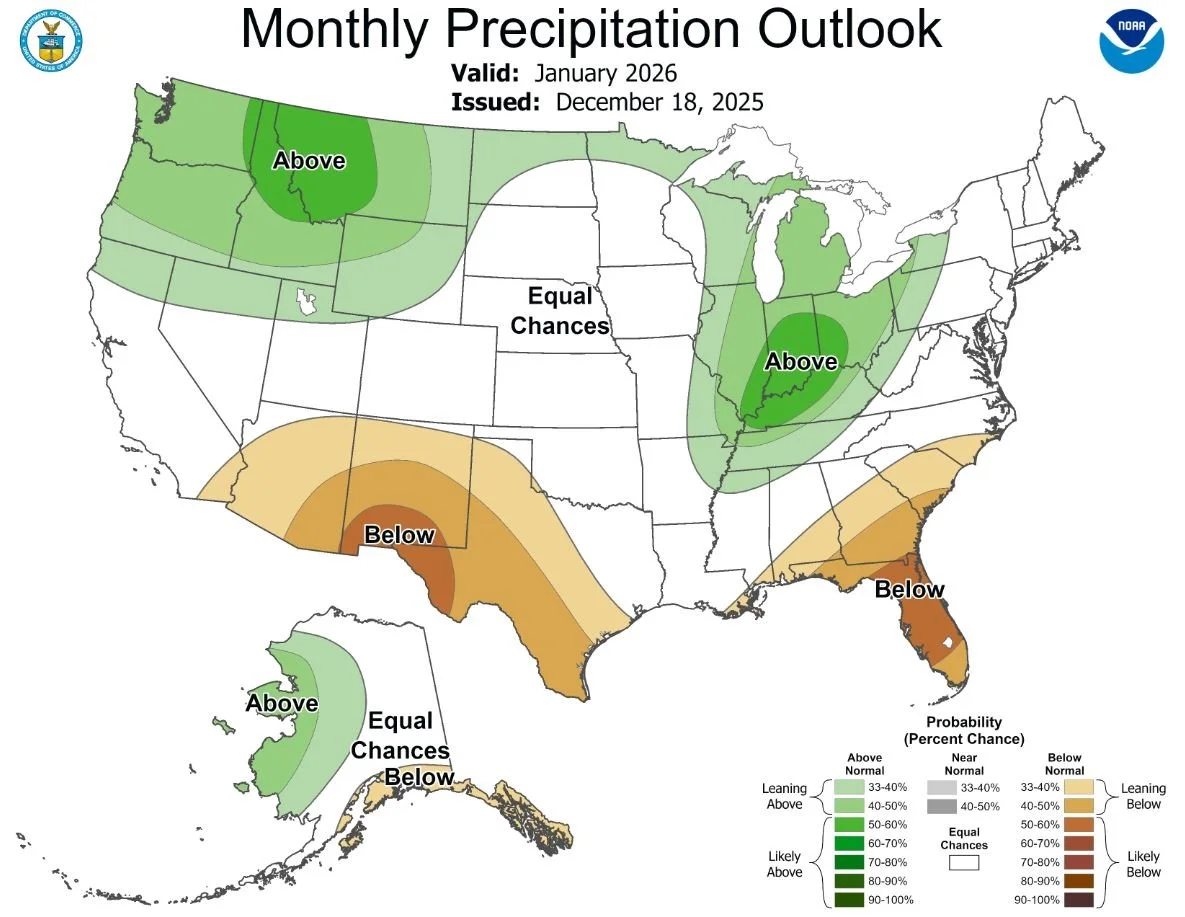
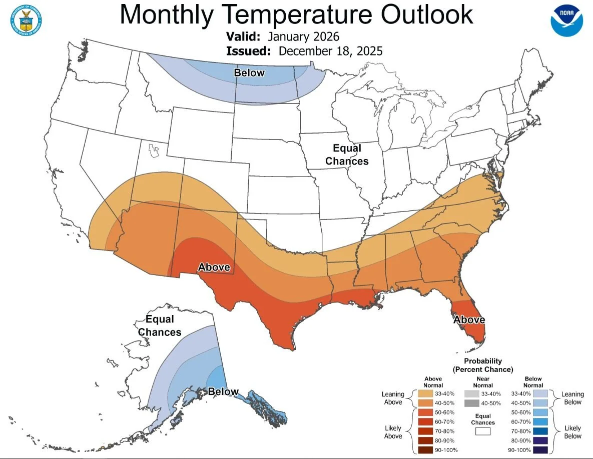
January Outlook: Wetter Pattern Favored Across the Midwest
Looking ahead, forecasters with the National Weather Service Climate Prediction Center indicate that January 2026 is likely to continue a wetter-than-normal pattern across much of the Midwest, including parts of northern Minnesota.
The CPC’s January outlook favors above-normal precipitation across the Great Lakes region, the Upper Midwest, and parts of the Ohio and Middle Mississippi Valleys, consistent with ongoing La Niña influences in the Pacific. While temperature signals are more uncertain due to a weakening La Niña, the precipitation signal is more consistent across multiple forecast models.
Across the Twin Cities, we appear to have equal chances (33.3% each) for above-, below-, and near-normal precipitation and temperature. This does not guarantee frequent snowstorms, but if temperatures remain cold enough to produce snow, there is a chance of at least continued near-normal snowfall. Normal snowfall for January is around 23.6 inches.
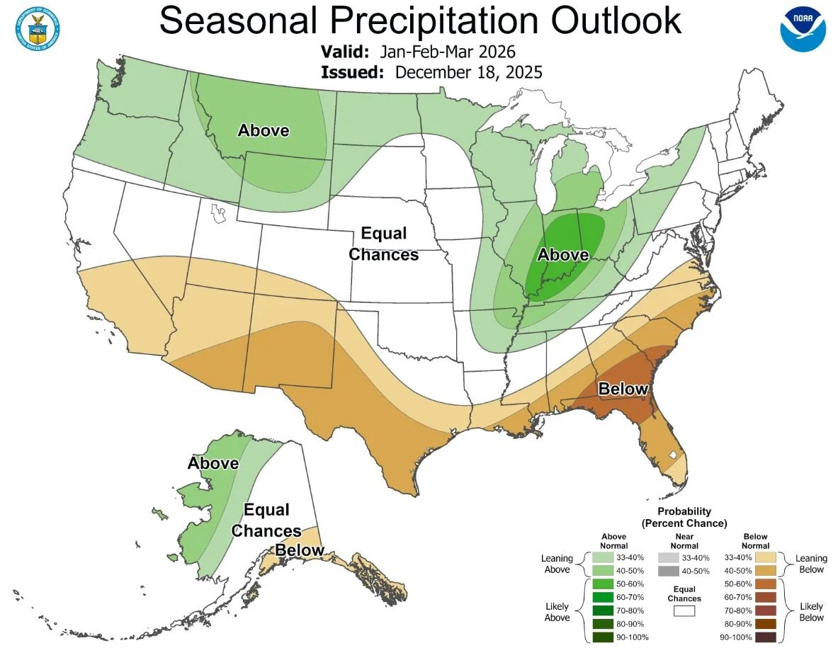
January–February–March Outlook: Active, Colder-Leaning Pattern for the Midwest
The CPC’s January–February–March (JFM) 2026 seasonal outlook continues to favor above-normal precipitation across most of the Midwest, including a 33-40% chance of slightly above-normal precipitation for Minnesota and the Twin Cities metro, extending through the heart of winter and into early spring.
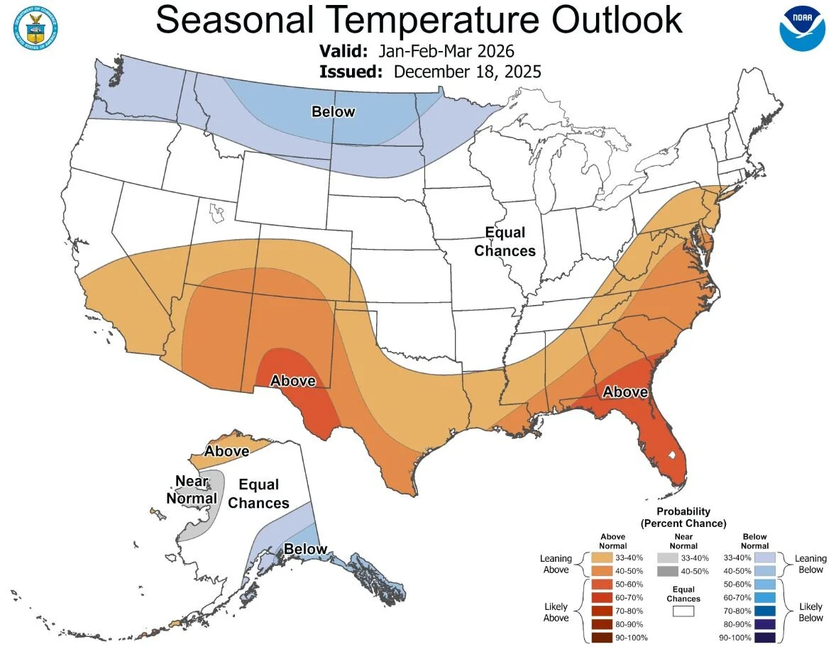
Temperature outlooks for JFM slightly favor below-normal temperatures across the northern Plains, Upper Midwest, and western Great Lakes, which would favor snow rather than mixed precipitation if moisture remains abundant. The Twin Cities metro appears to have equal chances of once again seeing above-, below-, and near-normal temperatures, with slightly below-normal temperatures extending just north and west of the Metro, extending farther into west-central to northern Minnesota.
While La Niña conditions are expected to weaken and potentially transition toward ENSO-neutral later in the season, forecasters with the CPC note that lingering La Niña-like atmospheric patterns could continue to influence winter weather across the region into early spring.
What This Means for the Twin Cities
After falling well behind last winter at this point, the Twin Cities now appear positioned for a much more seasonable and potentially above-average winter overall. With January and February typically the snowiest months of the year and precipitation favored across the Midwest, additional accumulation is likely.
While it remains far too early to determine whether this winter will approach historical extremes, the early rebound from last year’s snowfall deficit marks a clear shift in the region’s winter pattern.