
Major Winter Storm to Bring Blizzard Conditions, Heavy Snow Across Minnesota and Western Wisconsin
Published: December 28, 2025.
TWIN CITIES, MINNESOTA: The National Weather Service Twin Cities is warning residents across Minnesota and western Wisconsin to prepare for dangerous travel conditions as a powerful winter storm intensifies across the Upper Midwest from late Sunday morning through Monday morning.
Forecasters say a rapidly strengthening storm system moving out of the Central Plains will track toward the Great Lakes, bringing heavy snowfall, strong winds, and blizzard conditions to large portions of the region.
Snowfall Timeline and Impacts
Snow is expected to develop across western Minnesota near sunrise Sunday, while areas farther east initially see a rain-and-snow mix. As temperatures fall during the day, precipitation across eastern Minnesota and western Wisconsin will transition fully to snow.
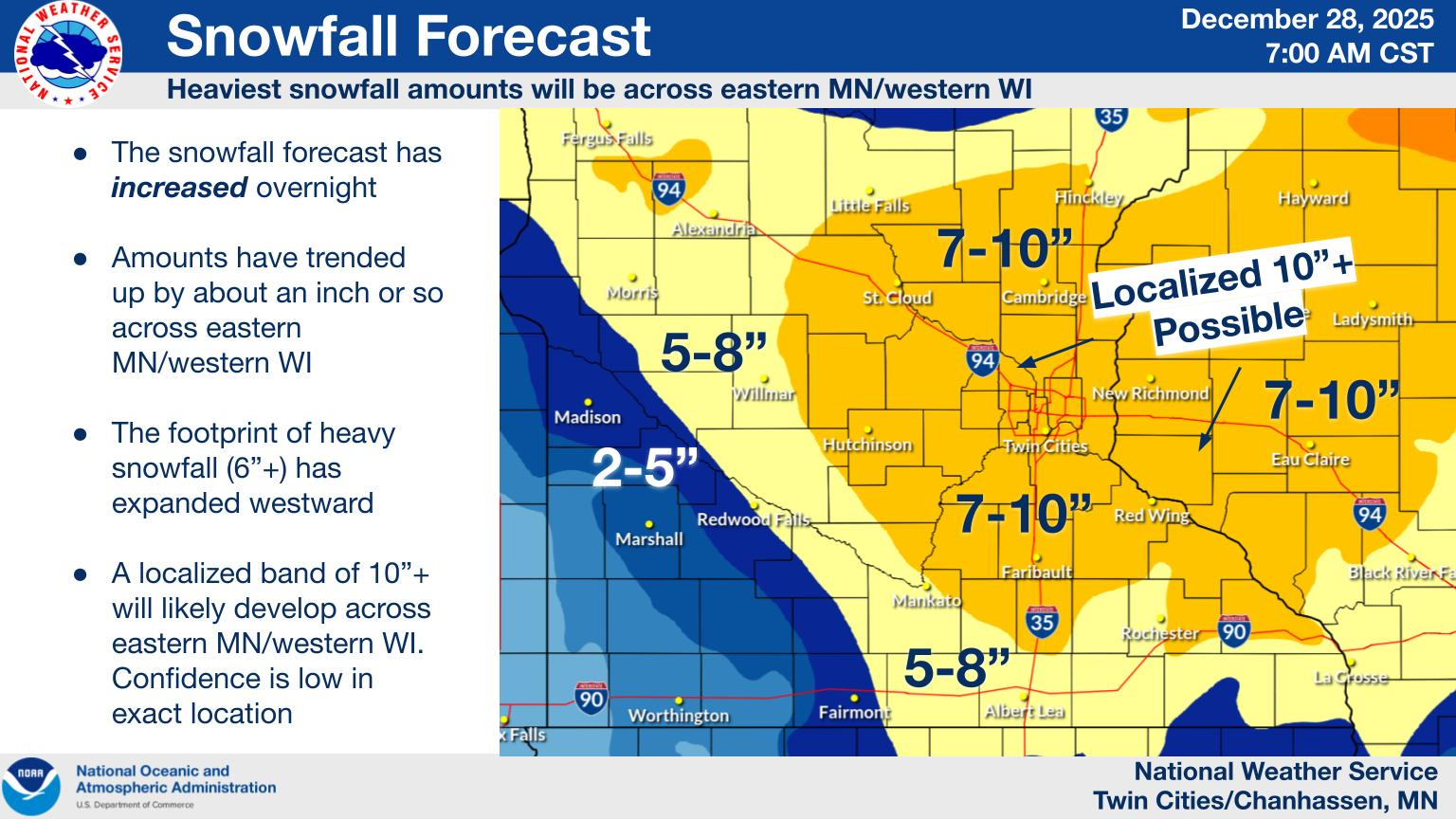
Steady snowfall will continue through early Monday morning, with widespread accumulations of 6 to 10 inches expected across eastern Minnesota and western Wisconsin. Lighter totals, generally a few inches, are forecast farther west.
Blizzard Conditions Expected
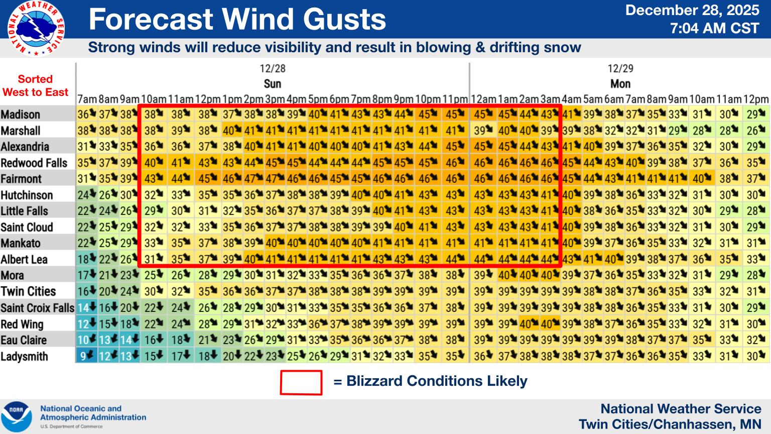
In addition to heavy snowfall, northwest winds gusting between 45 and 55 mph are expected to develop by Sunday evening. These winds will cause extensive blowing and drifting snow, creating whiteout conditions in open areas of central and southern Minnesota through early Monday morning.
The National Weather Service warns that visibility may drop to near zero at times, making travel extremely hazardous or impossible.
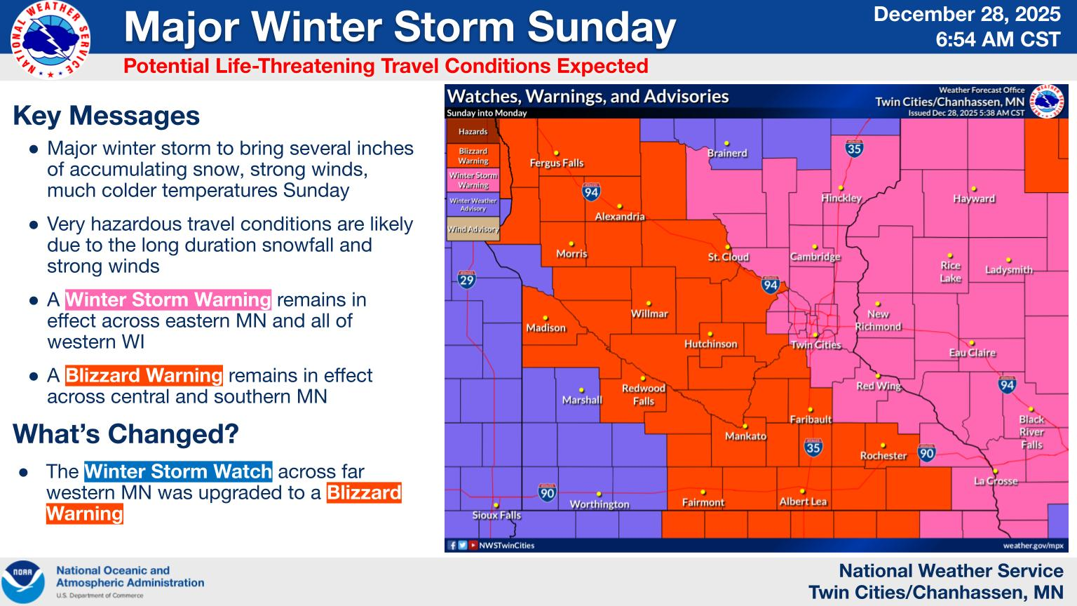
Blizzard Warning Areas
A Blizzard Warning is in effect from 9 a.m. Sunday to 9 a.m. Monday for portions of south-central Minnesota, including counties of Carver, Scott, Sibley, Nicollet, Blue Earth, Rice, Steele, Waseca, Freeborn, Faribault, Martin, Le Sueur, Brown, Watonwan
Cities within the warning area include Mankato, Albert Lea, Owatonna, Faribault, Shakopee, Chanhassen, Chaska, New Ulm, St. Peter, Waseca, Fairmont, and St. James.
Forecasters caution that travel should be restricted to emergencies only in these areas due to potentially life-threatening conditions.
Winter Storm Warning for Twin Cities, Eastern MN, and Western WI
A Winter Storm Warning remains in effect from noon Sunday through 9 a.m. Monday for much of east-central and southeastern Minnesota, including the Twin Cities metro, and western Wisconsin.
Counties under the warning include Hennepin, Ramsey, Anoka, Washington, Dakota, Isanti, Chisago, and Goodhue in Minnesota, along with portions of western Wisconsin. Snow totals of 7 to 10 inches are expected across these areas, with winds gusting up to 45 mph.
Travel and Safety Concerns
The National Weather Service warns that travel conditions will deteriorate rapidly later Sunday and remain dangerous through early Monday morning. The storm is expected to significantly impact the Monday morning commute, with blowing snow and drifting likely to obscure roadways.
Residents are urged to:
Avoid unnecessary travel
Keep a winter survival kit in vehicles
Stay with their vehicle if stranded
Monitor road conditions before traveling
In Minnesota, road conditions can be checked by calling 511 or visiting 511mn.org. In Wisconsin, travelers can call 511 or visit 511wi.gov.
Emergency officials stress that conditions may become treacherous quickly as snowfall intensifies and winds increase, urging residents to finalize preparations and adjust travel plans accordingly.
This is a developing weather situation. Updates will be provided as new information becomes available.