
RED FLAG WARNING: Critical Fire Danger Expected Across Minnesota Saturday with Strong Winds, Low Humidity
Published: March 27, 2026.
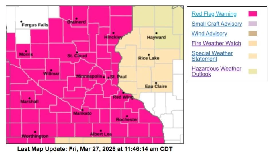
TWIN CITIES, MINNESOTA - A Red Flag Warning has been issued by the National Weather Service for much of central and southern Minnesota, signaling dangerous fire weather conditions expected to develop Saturday afternoon.
Timing and Areas Impacted
The warning is in effect from noon to 7 p.m. Saturday, impacting a wide portion of the state, including central, east-central, south-central, southeast, and west-central Minnesota. This includes heavily populated counties such as Hennepin, Ramsey, Dakota, Scott, and Washington.
Why Conditions Are Dangerous
Forecasters say a combination of weather factors will create an environment where fires can ignite easily and spread rapidly:
Temperatures: Climbing into the upper 50s to low 60s
Winds: Southwest winds 20 to 30 mph, with gusts reaching 35 to 45 mph
Humidity: Dropping to around 15–20%, with some areas potentially even lower
Dry Fuels: Vegetation remains dry and highly combustible
These conditions are being driven by a strong southerly flow developing as high pressure shifts east of the region, allowing warmer air to move in while very dry air remains in place. While the snow “just” melted for most places over the last week or so, fine/flashy fuels, like dead materials, dry grass, leaves, pine needles, or other materials around 1/4” diameter or less, can dry quickly under warm and dry conditions. They are often called 1-hour fuels because they can dry out in about an hour under the right conditions and ignite very easily.
Officials warn that any fire that starts could spread quickly and become difficult to control under these conditions. Even small sparks from equipment, vehicles, or discarded cigarettes could ignite fast-moving grass or brush fires.
Outdoor Burning Strongly Discouraged
Residents and land managers are strongly urged to avoid any outdoor burning on Saturday. This includes:
Burning brush or debris
Campfires
Fire pits
Use of equipment that may create sparks
Fire agencies are also being advised to remain alert and prepared for potential wildfire activity.
Conditions Improve After Saturday
The critical fire risk is expected to diminish Saturday evening into Sunday as winds decrease and moisture levels gradually improve.
What This Means for Residents
Saturday will feel warm and spring-like, but it will also bring heightened fire danger across the region. Taking precautions, especially avoiding open flames, will be critical to preventing potentially dangerous, fast-spreading fires.
Stay with Limitless Media News for continued updates, including any fire incidents or changes to conditions.