
Severe Storm Threat Could Impact Twin Cities, Southern Minnesota Sunday Night
Severe Weather Outlook for Sunday, May 17, 2026.
Published: May 15, 2026
TWIN CITIES, MINNESOTA: A potentially active weather pattern is expected to develop across the Upper Midwest this weekend, with the potential for severe thunderstorms Sunday evening and overnight across much of Minnesota and western Wisconsin, including the Twin Cities metro, as a few disturbances are forecast to work through the region.
The more significant severe weather setup currently appears to be on Sunday, when conditions potentially become favorable for strong to severe thunderstorms capable of damaging winds, large hail, heavy rainfall, and possibly tornadoes.
Saturday Threat Expected to Stay Mainly South
The first round of weekend thunderstorms is expected Saturday, though the highest severe threat currently appears likely to remain across southern Minnesota and into Iowa.
A cluster of storms is forecast to possibly develop across parts of South Dakota, Nebraska, and Iowa before tracking southeast along the strongest instability corridor toward the Mississippi Valley. Some lingering showers or thunderstorms could drift into parts of southern Minnesota or western Wisconsin early Sunday morning, though confidence remains lower regarding how far north that activity may reach.
Sunday Could Bring Stronger to Severe Weather Setup
Sunday currently appears to present the better opportunity for severe weather locally. The latest model guidance indicates the atmosphere could become increasingly unstable Sunday afternoon and evening, with strong CAPE values potentially reaching 2,000 to 3,000 J/kg, a measure of thunderstorm energy. This instability, combined with deep-layer wind shear, will help create an environment supportive of organized severe storms across the region.
Guidance shows that thunderstorms may initially develop as isolated supercells across the Dakotas and central Plains before eventually merging into a larger mesoscale convective system, or MCS, that would track eastward into Minnesota and Wisconsin Sunday evening and overnight. If storms organize into a squall line before reaching Minnesota, damaging straight-line winds would likely become the primary severe threat. However, portions of western Minnesota could still see a tornado and a large hail threat if storms remain more isolated for a longer period.
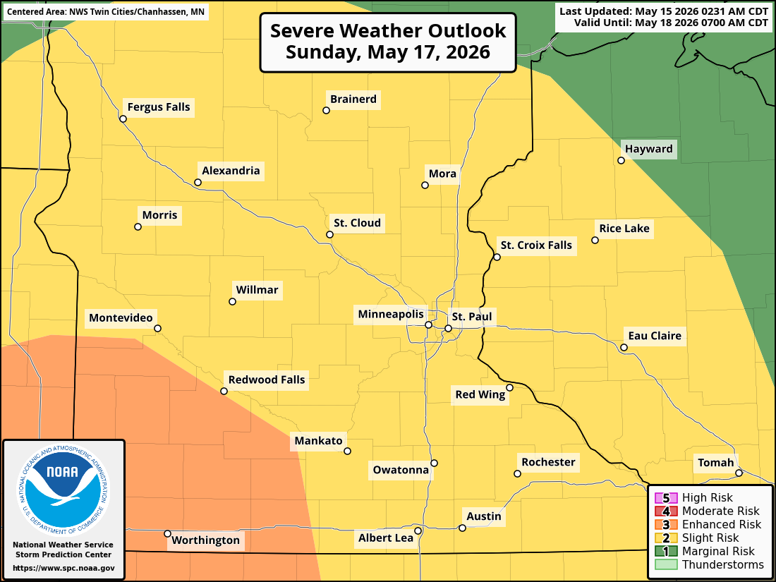
Due to these threats, the Storm Prediction Center has placed a Slight Risk (2/5) across a large portion of Minnesota and western Wisconsin for Sunday. An Enhanced Risk (3/5) is in place across southwestern Minnesota and off to the south and southwest, where there is that heightened chance of isolated very large hail, damaging winds, and even a few tornadoes.
Timing Still Uncertain
Current forecast guidance suggests the strongest storms may not arrive in eastern Minnesota and the Twin Cities until well after sunset Sunday night.
If that timing holds, storms may gradually weaken as they move east into the metro area and western Wisconsin overnight as we lose instability with the sun setting. However, there remains some uncertainty about how quickly this activity might track eastward or whether there might be earlier storm development, which could increase the severe weather risk locally, as there is greater instability.
Forecast details, including storm timing and intensity, are expected to become clearer over the next couple of days.
Heavy Rainfall Also Possible
In addition to severe weather, there is also a potential for widespread soaking rainfall.
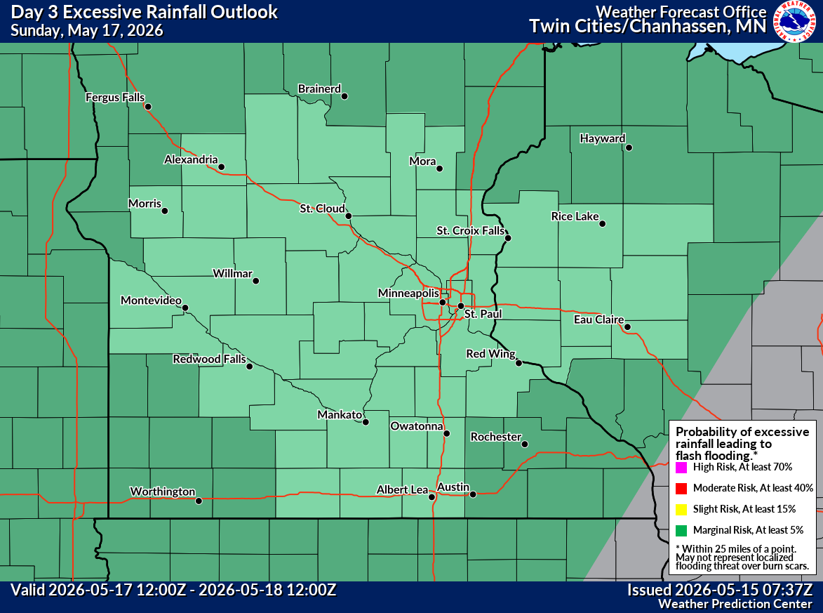
The latest model guidance suggests a greater than 50% chance that many areas could receive 1 to 2 inches of rain from Sunday’s storms, with additional rounds of thunderstorms possible Monday into Tuesday. Since the rain could be heavy at times and be training, there is a potential for localized flash flooding in parts of the Twin Cities metro. The Weather Prediction Center has put the Twin Cities metro under a Marginal Risk (1/5) for excessive rain on Sunday and a Marginal (1/5) to Slight Risk (2/5) on Monday.
The rainfall would provide a much-needed soaking rain for many areas after a relatively dry start to May.

What You Need To Know
Severe thunderstorms are possible Sunday evening into overnight across Minnesota and western Wisconsin.
Damaging winds currently appear to be the primary severe threat.
Large hail and tornadoes may also be possible, especially farther west if storms remain isolated longer.
Heavy rainfall of 1 to 2 inches may occur in some areas.
Additional thunderstorms are possible Monday into Tuesday.
Forecast timing and storm intensity could still change over the coming days.