
Severe Storms, Large Hail, Damaging Winds, and Heavy Rain Possible Across Parts of Minnesota Tonight
Published: May 17, 2026
TWIN CITIES, MINNESOTA: Here is the latest weather update for this evening, as strong-to-severe thunderstorms are expected Sunday evening into the overnight as an active weather pattern moves into the Upper Midwest.
Most of the Twin Cities should be cool and dry this morning as winds are currently out of the northeast, but we will have to watch how quickly temperatures and humidity increase across Minnesota and western Wisconsin as winds are expected to gradually turn out of the southeast by late morning. As they do, conditions are forecast to become more favorable for severe weather, as the southeasterly flow will allow warmer, more humid air to move northward. Cloudy conditions could limit how much instability we build here across the Twin Cities metro, which could hinder our chances of seeing strong to severe storms.
Across southern Minnesota, dew points are forecast to climb into the upper 50s and 60s, creating a more unstable atmosphere capable of supporting severe thunderstorms, and this is likely where we will see the greatest potential for strong-to-severe storms today in Minnesota, which we will talk more about below. As previously mentioned, the biggest uncertainty remains how far north that unstable air will spread, as widespread cloud cover limits daytime heating.
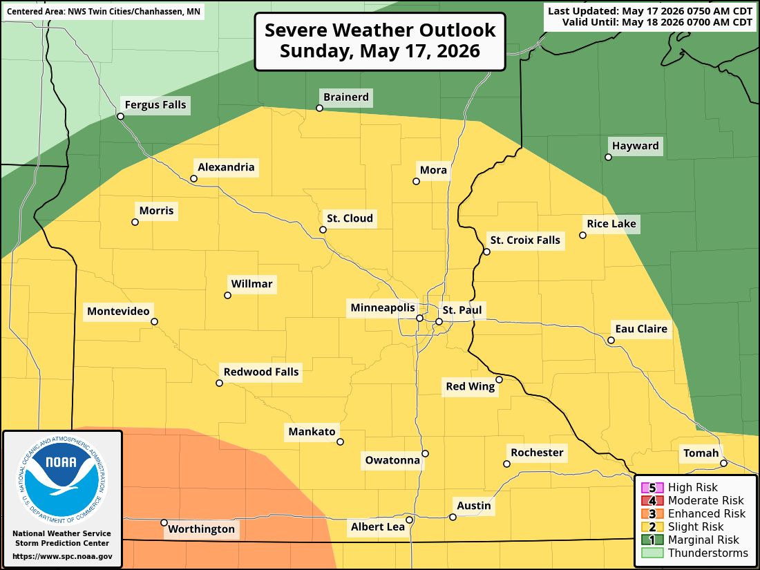
Southern Minnesota Appears Most Favorable for Severe Weather
Thunderstorms are expected to rapidly develop late Sunday afternoon across the eastern Dakotas near a developing low-pressure system forecast to move northeast into Minnesota and Wisconsin.
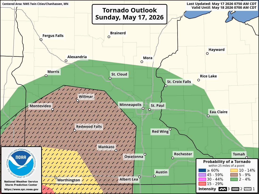
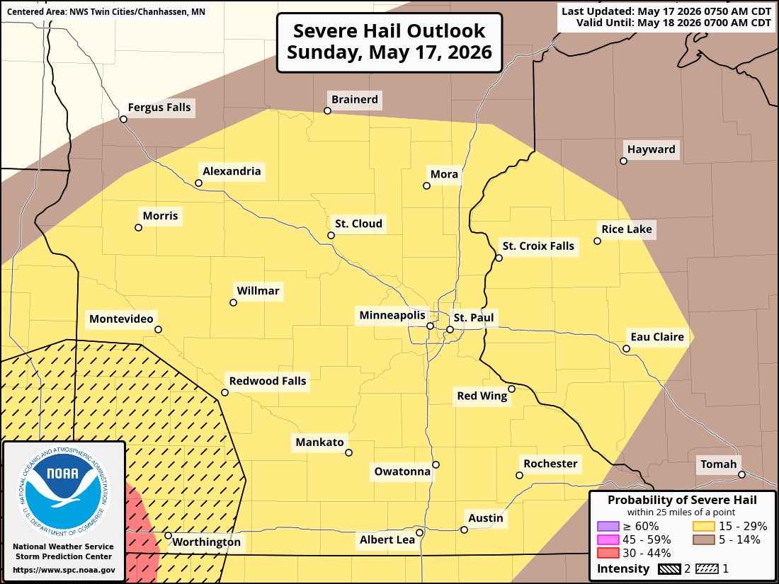
Initially, storms are expected to be more discrete with supercells possible, with all modes of severe weather possible, including:
Very large hail up to 2 to 3 inches in diameter
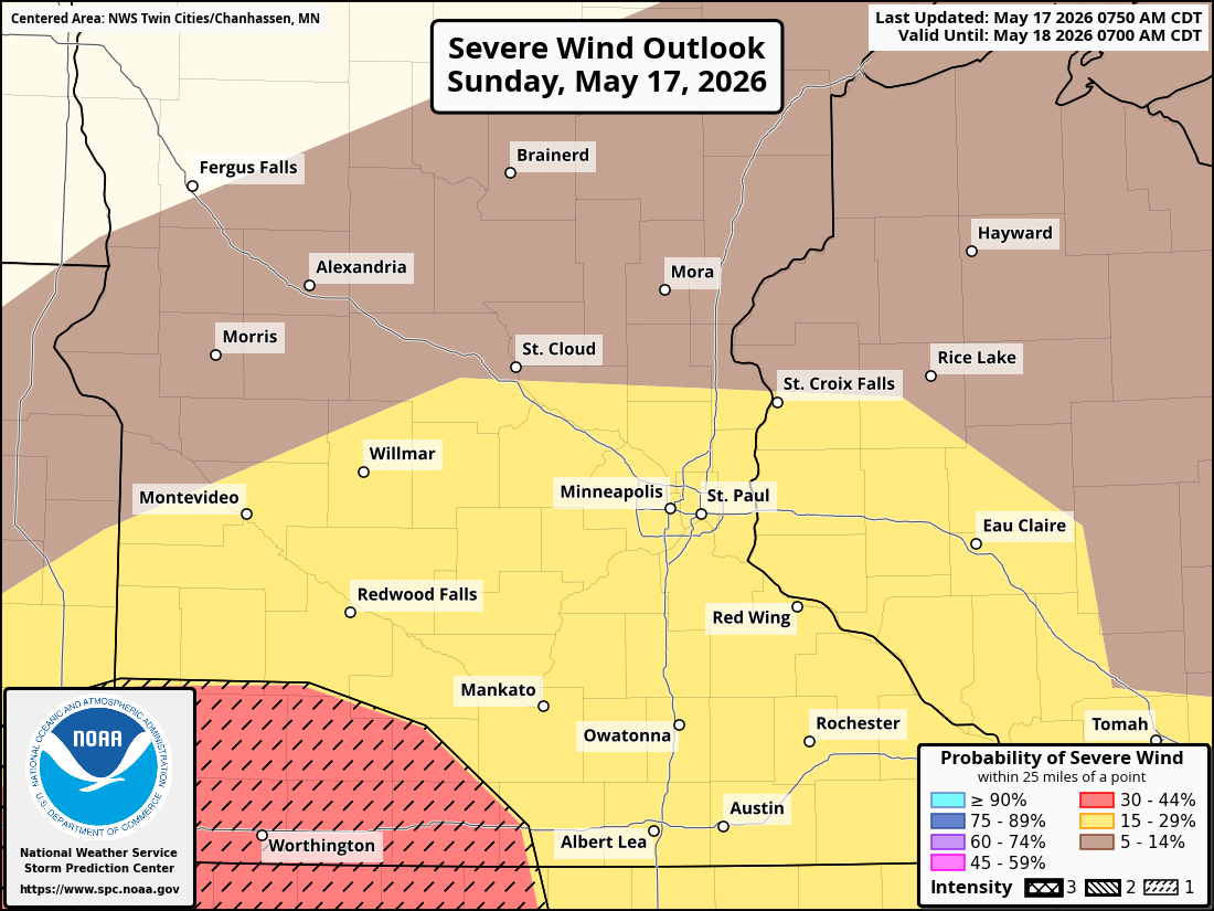
Damaging straight-line winds
A few tornadoes
As storms move east into western Minnesota during the evening hours, the discrete supercells are forecast to merge into a larger squall line or mesoscale convective system (MCS). Once storms evolve into a line, the severe threat will primarily become a damaging wind threat, though isolated tornadoes could still occur within embedded circulations along the line. The lingering tornado threat is thanks to the southeastern winds ahead of the line, which will create strong low-level wind shear and helicity, ingredients that can support brief QLCS tornadoes embedded within the line of storms.
Again, the highest severe weather threat looks to be focused across southern Minnesota, with high-resolution model guidance generally showing the best ingredients and instability near and south of a line from Marshall to Mankato to Red Wing. In those areas, instability levels may approach 1,000 J/kg of surface-based CAPE, supportive of stronger severe storms.
We will be monitoring how far north instability will build this afternoon across central Minnesota and western Wisconsin, including parts of the Twin Cities metro. If strong to severe storms do happen to develop late this afternoon and into the late evening hours, damaging straight-line winds look to be the primary threat, but an isolated tornado and large hail can’t be ruled out, as the favorable wind profile out of the southeast could still support a brief spin-up.
Expected Timing
Current forecast timing:
Western Minnesota: approximately 7 p.m. to 9 p.m.
Central Minnesota and the Twin Cities metro: approximately 9 p.m. to 11 p.m.
Western Wisconsin: approximately 11 p.m. to 1 a.m.
Storms are expected to gradually weaken after midnight as instability decreases with the sun setting, though showers and thunderstorms may continue overnight before tapering off around sunrise Monday.
Heavy Rainfall and Flooding Concerns
Even if the Twin Cities metro doesn’t see the severe weather, heavy rainfall is still expected to become a concern through Monday night as multiple rounds of thunderstorms move through the region. Much of Minnesota and western Wisconsin could receive 1 to 2 inches of rain, which could be the first widespread soaking rainfall event of the month for many locations across the state.
Localized rainfall totals of 3 to 4 inches are possible in areas where thunderstorms repeatedly track over the same locations (training thunderstorms) or slow down. While widespread flooding is not currently expected, localized ponding and isolated flooding could develop in areas that receive the heaviest rainfall.
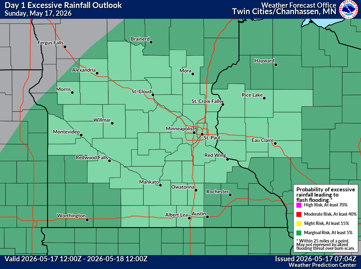
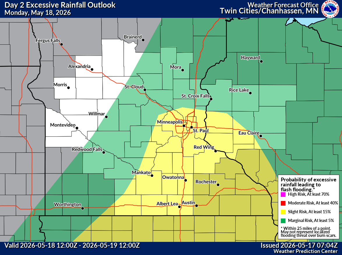
No significant changes from the Weather Prediction Center (WPC) on our excessive rainfall outlook for today across the Twin Cities metro. We remain under a Marginal Risk (1/5) for excessive rainfall. For Monday, they shifted the Slight Risk (2/5) for excessive rainfall westward, so the entire Twin Cities metro is now under the Slight Risk.
Additional Storm Chances Monday Night
Most of Monday daytime is expected to remain dry, though there is a chance that some remnant outflow boundaries or MCV from overnight activity could help spark additional thunderstorms later in the day.
Another round of showers and thunderstorms is expected Monday night, though the greatest severe weather threat is currently forecast to remain south of Minnesota across Iowa and southern Wisconsin. If there are any localized boundaries shed, they could locally enhance storm development if conditions align on Monday evening, allowing an isolated strong-to-severe storm to develop. The primary threat from this activity would be damaging wind gusts, but again, isolated large hail or a tornado can’t be ruled out.
Continue to monitor updated forecasts throughout the day day today, and have multiple ways to receive severe weather warnings tonight, especially given the potential for storms to arrive after dark.