
Blizzard Warning Issued for Twin Cities Metro as Historic March Winter Storm Moves In
Published: March 14, 2026, at 2:45pm
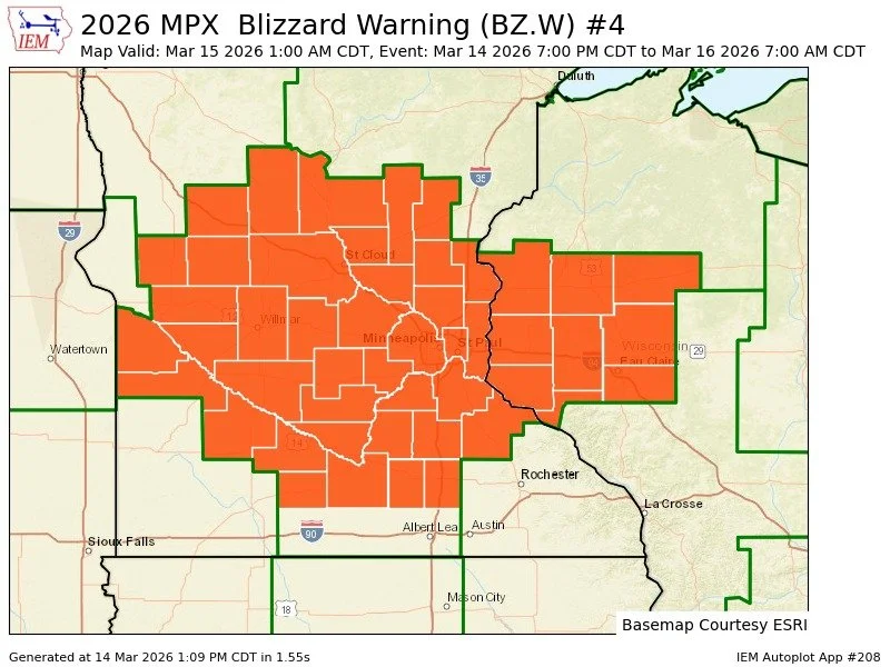
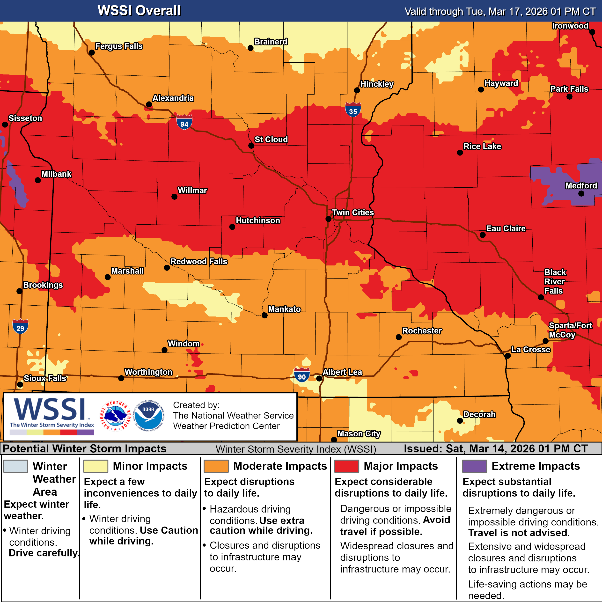
TWIN CITIES, MINNESOTA: A powerful and potentially historic March winter storm is moving into the Upper Midwest, prompting the National Weather Service (NWS) Twin Cities to upgrade the Twin Cities metro and much of central and southern Minnesota from a Winter Storm Warning to a Blizzard Warning beginning late Saturday night.
The storm will bring heavy snowfall, extremely strong winds, and near-whiteout conditions, creating a high likelihood that travel could become very difficult or even impossible through Sunday.
Blizzard Warning Details
The Blizzard Warning is in effect from 10 p.m. Saturday through 4 a.m. Monday for a large portion of the region, including the Twin Cities metro and surrounding counties. Counties included in the warning area include:
Wright
Sherburne
Benton
Stearns
Isanti
Chisago
Goodhue
Hennepin
Ramsey
Dakota
Anoka
Washington
Scott
Carver
Cities affected include Minneapolis, St. Paul, Shakopee, Chaska, Stillwater, Hastings, Red Wing, St. Cloud, Elk River, Blaine, and Cambridge, among others. The warning signals a combination of heavy falling snow and strong winds that will significantly reduce visibility and create dangerous travel conditions.
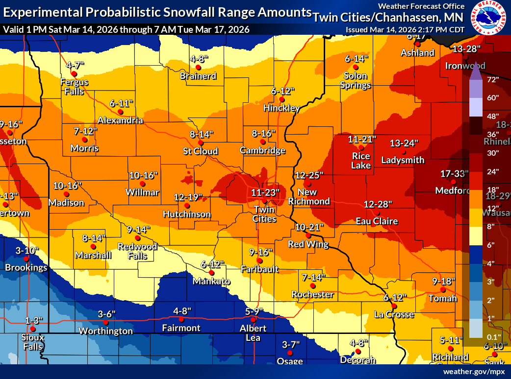
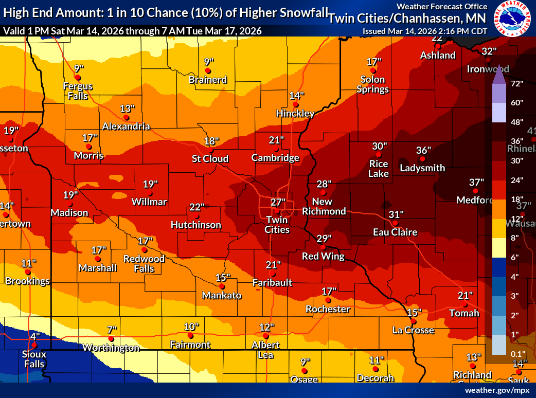
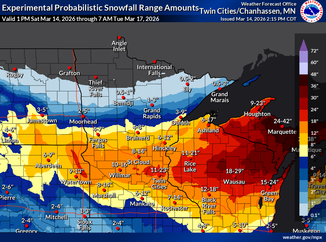
Expected Snowfall Totals
The latest guidance shows widespread snowfall totals of 12 to 18 inches across central Minnesota and western Wisconsin, including the Twin Cities. A narrow corridor of heavier snow may approach 20 inches or more, particularly from southeastern Minnesota into western Wisconsin.
The storm is expected to intensify quickly on Saturday evening, with snowfall rates reaching 2 to 2.5 inches per hour late Saturday night through Sunday morning.
The heaviest six-hour window could occur roughly between 1 a.m. and 7 a.m. Sunday, when several inches of snow may accumulate rapidly.
Blizzard Conditions Sunday
While heavy snowfall will be a major factor overnight, the most dangerous conditions are expected on Sunday as winds strengthen dramatically.
Forecast wind gusts include:
35–45 mph across much of southern Minnesota
40–50 mph possible in some areas
Up to 55 mph possible in the Minnesota River Valley
These winds will produce blowing and drifting snow, which can reduce visibility to near zero at times, creating true blizzard conditions.
Even as snowfall begins to taper Sunday afternoon and evening, strong winds will continue to blow snow across roads, prolonging hazardous conditions.
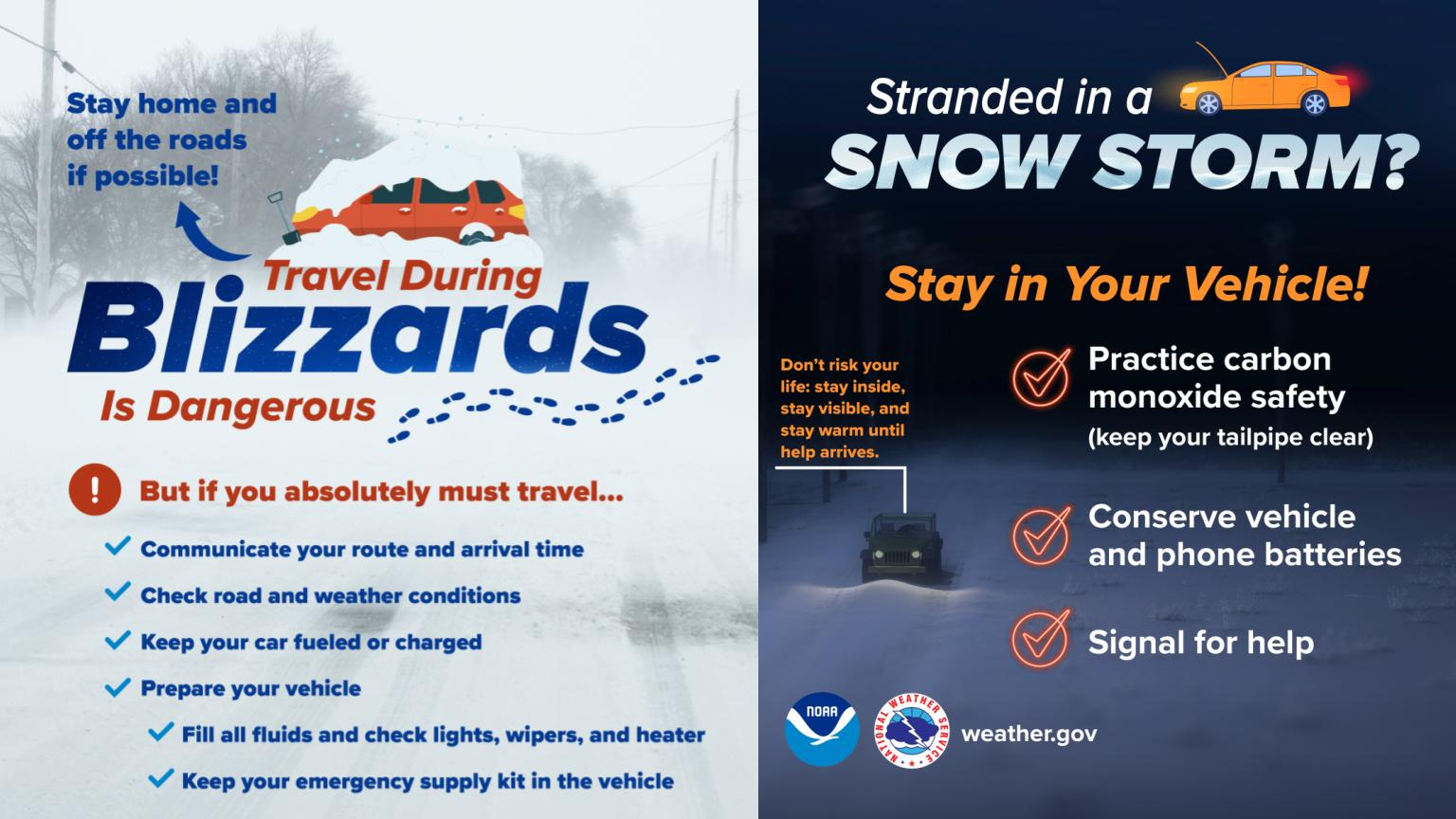
Travel Could Become Impossible
The National Weather Service warns that travel may rapidly deteriorate late Saturday evening, becoming dangerous overnight and potentially impossible Sunday. Whiteout conditions could develop as heavy snowfall combines with powerful winds, making it extremely difficult for drivers to see the road.
Officials strongly recommend avoiding travel on Sunday unless absolutely necessary.
Anyone who must travel should carry a winter survival kit, including:
Extra blankets and warm clothing
Food and water
A flashlight and phone charger
A shovel and sand or cat litter for traction
Drivers who become stranded are advised to remain with their vehicle and call for assistance.
Wintry Mix Possible in Southern Minnesota
While most of the region will see all snow, far southern Minnesota along the Interstate 90 corridor may initially experience a mix of rain, freezing rain, and sleet late Saturday night.
Forecasters say areas near the Iowa border could see:
Up to a half-inch of sleet
Around one-tenth of an inch of ice
That mixed precipitation is expected to transition to snow by Sunday morning as colder air deepens across the region.
Heavy, Wet Snow May Cause Additional Problems
Another concern with this storm is the high moisture content of the snow, which will likely make it heavy and dense.
This type of snow can:
Place stress on trees and power lines
Increase the risk of broken branches
Make shoveling physically strenuous and potentially dangerous
Officials are urging residents to use caution while clearing snow, especially those with heart conditions or other health concerns.
Storm Timeline
Saturday Afternoon
Snow begins developing across southern and western Minnesota.
Saturday Evening
Snow intensifies across the Twin Cities region.
Late Saturday Night – Early Sunday Morning
Peak snowfall rates, potentially exceeding 2 inches per hour.
Sunday Morning
Heavy snow continues; winds begin increasing.
Sunday Afternoon and Evening
Snow gradually tapers, but strong winds create blizzard conditions with blowing snow.
Early Monday
Snow ends, but blowing snow and drifting may continue impacting travel.
Possible Historic March Storm
This storm could rank among the most significant March snowstorms in recent years for the region, with high confidence that most locations will receive at least 8 inches of snow, and many areas will see more than a foot.
The exact placement of the heaviest band of snowfall may still shift slightly as the storm develops, but current forecasts place the Twin Cities metro within the core of the storm’s most intense snowfall.
How to Stay Updated
Residents are encouraged to monitor the latest weather updates and road conditions as the storm unfolds. Road conditions can be checked through Minnesota 511, and the latest forecasts and warnings are available from the National Weather Service.
With heavy snow, strong winds, and whiteout conditions expected, officials stress that staying off the roads Sunday may be the safest option for most residents.