
Winter Weather Advisory Issued for Central and Eastern Minnesota as Another Round of Freezing Rain Threatens Travel Monday Night into Tuesday Afternoon
Winter Weather Advisory issued from 9 PM Monday to Noon Tuesday
Published: January 5, 2026, at 7 am.
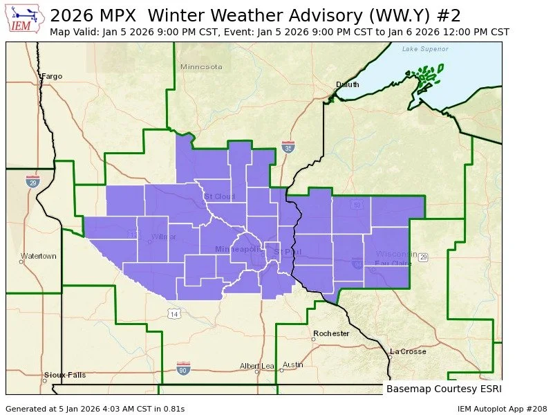
TWIN CITIES, MINNESOTA: A Winter Weather Advisory has been issued for parts of central and eastern Minnesota as another round of freezing rain is expected to develop late Monday evening and continue into Tuesday morning, creating hazardous travel conditions and the potential for localized power disruptions.
The advisory is in effect from 9:00 p.m. Monday until noon Tuesday, with ice accumulations of up to 0.2 inch possible in the hardest-hit areas.
The advisory covers the following Minnesota counties: McLeod, Sherburne, Sibley, Wright, Anoka, Carver, Chisago, Dakota, Hennepin, Isanti, Kanabec, Mille Lacs, Ramsey, Scott, and Washington.
What to Expect
Freezing rain is expected to overspread the southern half of Minnesota Monday evening, driven by a system working into the region from the Rockies into the central Plains and Iowa. A narrow but potentially impactful band of precipitation is forecast to develop from west-central Minnesota near Willmar through the Twin Cities metro and into western Wisconsin, including the Eau Claire area.
The temperature will be critical during the next round of precipitation, as guidance indicates over an inch of liquid precipitation is possible in some areas. Temperatures near the core of the band are expected to hover just a few degrees above freezing. This should limit the risk of a widespread, damaging ice storm, but travel impacts remain a significant concern.
Potential for Upgrade
If guidance indicates colder surface temperatures or heavier precipitation rates (which can lead to colder temperatures), an upgrade or issuance to an Ice Storm Warning could be possible later today, according to the NWS Twin Cities office. They state that this would occur particularly if the freezing rain band intensifies or shifts slightly north or south.
Travel and Infrastructure Impacts
Road conditions may deteriorate rapidly, especially on untreated roads, bridges, and overpasses.
Ice can accumulate even when air temperatures are slightly above freezing, particularly on cold ground and elevated surfaces.
The Tuesday morning commute is expected to be the most affected period.
While widespread power outages are not guaranteed, localized outages are possible if ice builds up on trees or power lines.
Heavy rainfall may prevent ice from accumulating on elevated surfaces due to runoff, but cold ground temperatures mean slick conditions are still likely.
Improving Conditions Tuesday
The freezing rain band is expected to shift east on Tuesday morning, with temperatures warming into the mid-30s by Tuesday afternoon, leading to gradually improving road conditions.
Safety Reminders
Residents are urged to:
Slow down and allow extra time for travel
Use caution on bridges, ramps, and sidewalks
Prepare for the possibility of brief power outages
Check current road conditions by calling 511 or visiting 511mn.org
Further updates are expected as the system evolves and confidence in precipitation placement and temperatures increases.
Forecast graphics provided by the NWS Twin Cities.