
High Wind Warning Issued for Twin Cities Region as Powerful Storm System Brings Dangerous Winds and Weekend Snow Potential
Published: March 12, 2026
3 PM UPDATE: Winter Storm Watch Issued for Large Portion of Minnesota; Up to 20 Inches of Snow Possible This Weekend
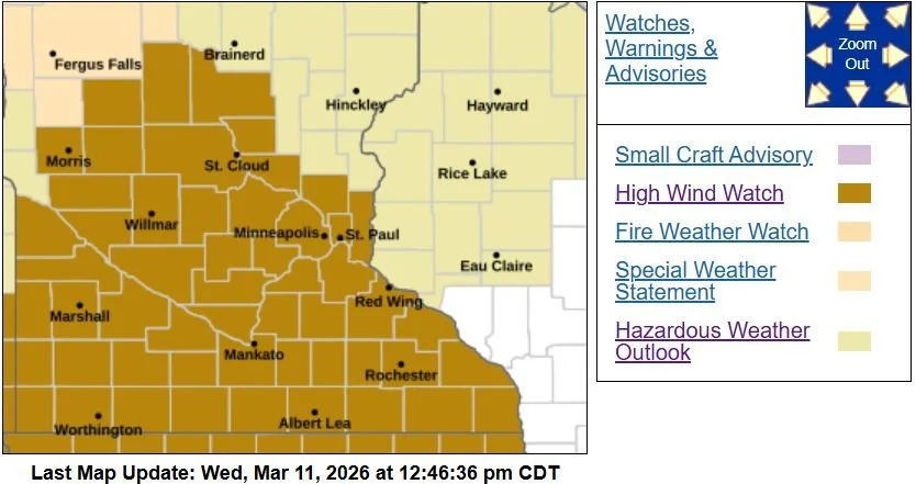
TWIN CITIES, MINNESOTA: The National Weather Service Twin Cities upgraded much of the Twin Cities region to a High Wind Warning on Wednesday evening, warning that dangerous wind gusts up to 60 mph could impact travel, utilities, and property overnight into Friday morning.
The warning is in effect from midnight Thursday night until 10 a.m. Friday and includes Benton, Morrison, Sherburne, Wright, Anoka, Carver, Dakota, Hennepin, Ramsey, Scott, Washington, Le Sueur, Rice, Steele, and Goodhue counties, covering much of central and southern Minnesota, including the entire Twin Cities metro area.
Strong Winds Expected Overnight
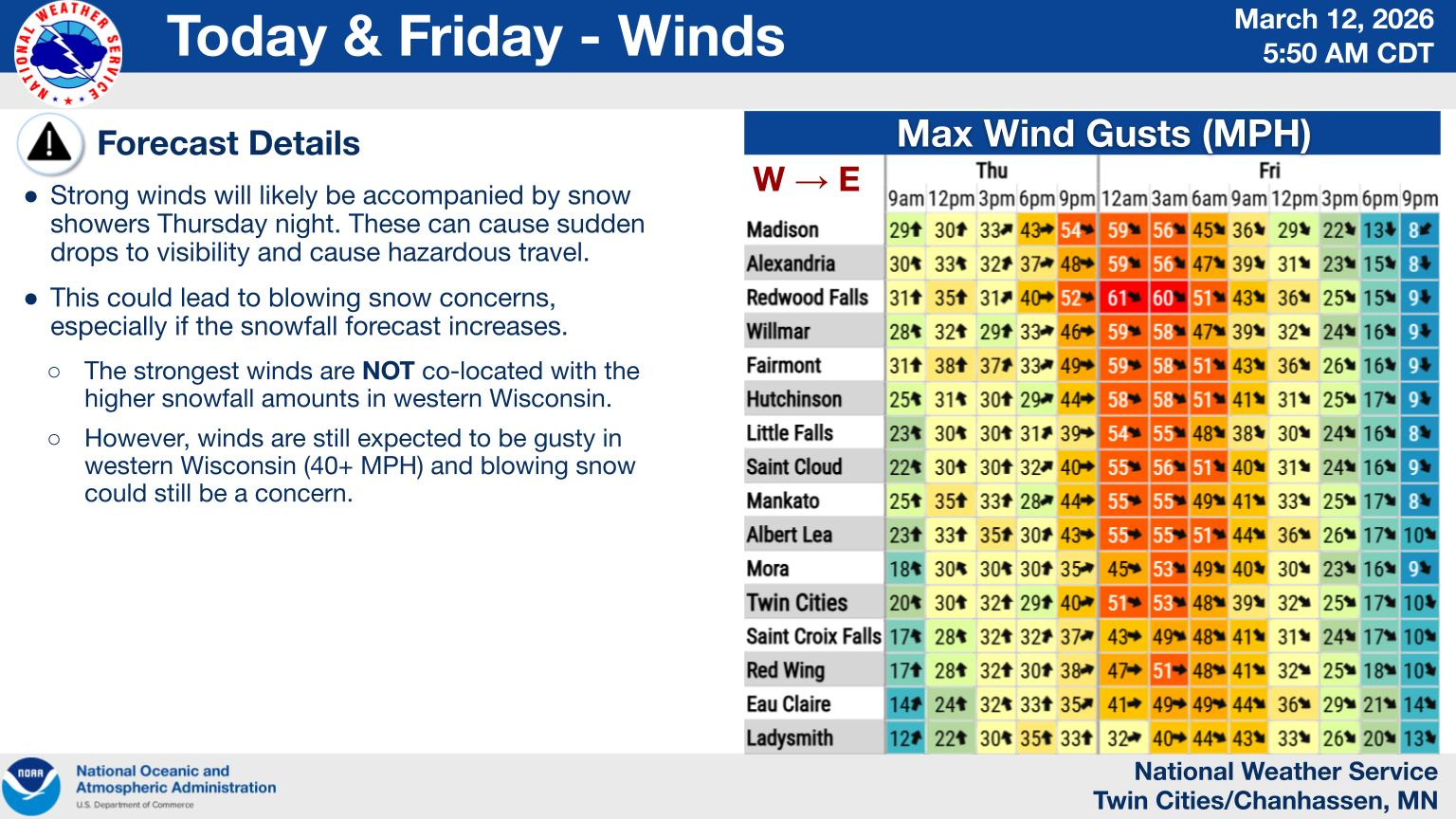
According to the National Weather Service, northwest winds of 25 to 35 mph with gusts up to 60 mph are expected as a powerful storm system rapidly intensifies across the Upper Midwest. The strongest winds will develop late Thursday evening and overnight into early Friday morning, particularly after the system’s cold front moves through and winds shift to the west and northwest.
The warning indicates the winds could be strong enough to cause widespread impacts.
Potential impacts include:
Downed trees and power lines
Scattered to widespread power outages
Hazardous travel conditions
Difficult driving for high-profile vehicles such as trucks, vans, and buses
Blowing debris and unsecured outdoor objects
Residents are urged to secure loose outdoor items such as patio furniture, garbage cans, and decorations that could become airborne in the strong winds.
Provided by the NWS Twin Cities.
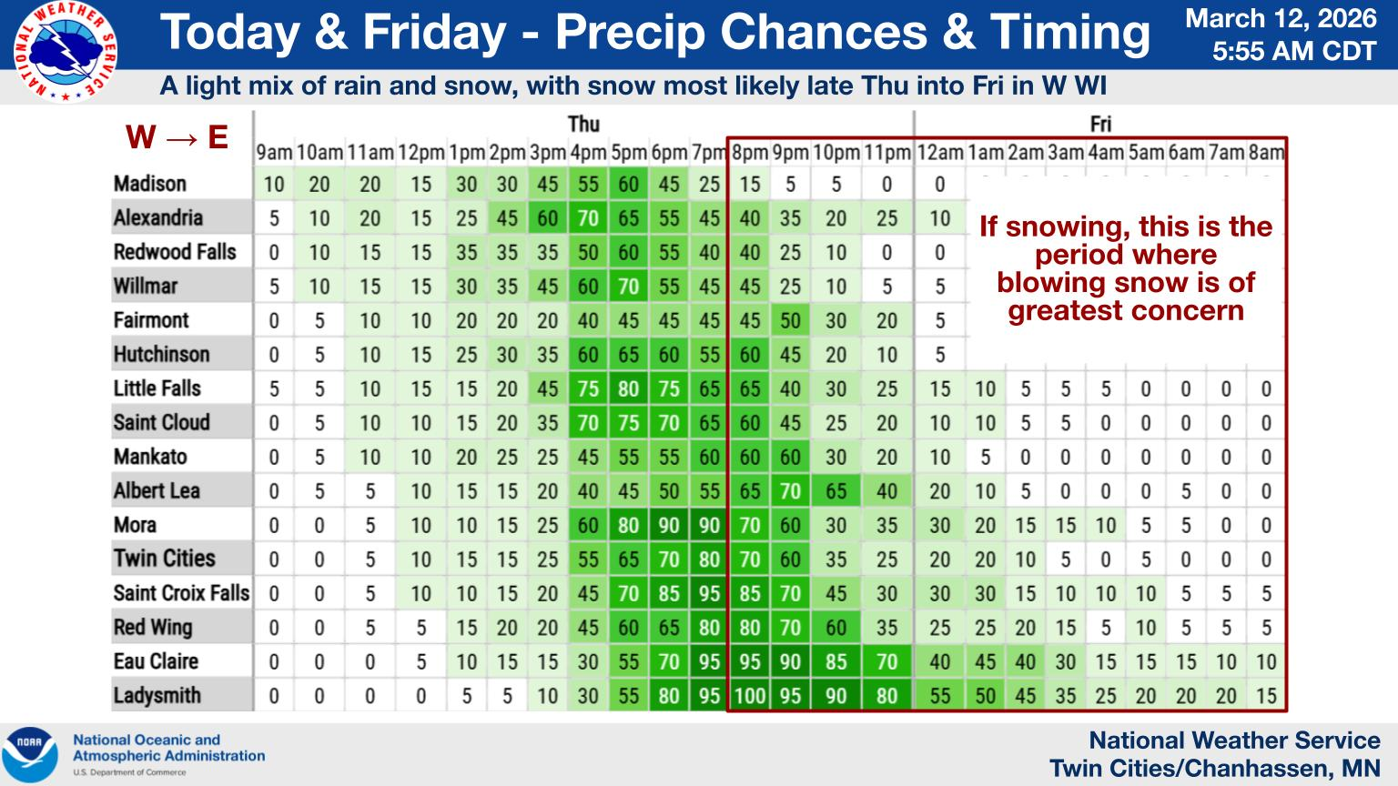
Rain and Snow Transition Thursday
The wind event is tied to a rapidly strengthening low-pressure system moving east from the Rocky Mountains into the Dakotas. As the system approaches Minnesota Thursday afternoon and evening, light snow may begin early Thursday afternoon in parts of the region. As temperatures rise with an approaching warm front, precipitation will transition to rain across much of southern Minnesota. Some areas, especially farther north and east, may experience a mix of rain and snow before switching back to snow later in the evening.
Across most of southern Minnesota, snowfall totals from this system are expected to remain around one inch or less, though areas in western Wisconsin could see more significant accumulation. Parts of Rusk County, Wisconsin, could receive 3 to 5 inches of snow, prompting a Winter Weather Advisory there from the NWS Twin Cities.
Provided by the NWS Twin Cities.
Why Winds Will Be So Strong
The dangerous wind potential is due to a rapidly tightening pressure gradient between the strengthening low-pressure system moving across northern Minnesota and high pressure building behind it. The tighter the pressure gradient, the stronger the winds. The latest forecast guidance indicates very strong winds within the lower atmosphere, with speeds of 50 to 80 knots (roughly 60 to 90 mph) just above the surface.
This setup allows some of those stronger winds aloft to mix down to the surface, producing the potential for 60 mph gusts across portions of western and southern Minnesota.
Conditions should gradually improve on Friday as the storm system moves east into the Great Lakes region, with snow and precipitation expected to taper off by late Friday afternoon or evening, while winds should steadily weaken during the day.
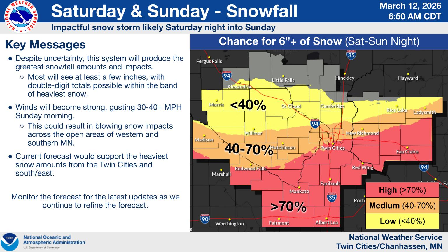
Another Storm Could Bring Heavy Snow This Weekend
While the strong winds are the immediate concern, another potentially significant storm could impact Minnesota this weekend. A developing low-pressure system over Colorado is expected to move northeast through the central United States Saturday into Sunday, pulling Pacific and Gulf moisture into the Upper Midwest.
Current forecast guidance suggests heavy snow is likely late Saturday through Sunday, with parts of Central and southern Minnesota potentially receiving over 6 inches. Some areas could see as much as 8 to 12 inches of snow, but there remains uncertainty between model guidance on where the heaviest of the snow could fall. Strong winds may accompany the snowfall, leading to blowing snow and reduced visibility.
It is too early to determine exact snowfall totals, but confidence is increasing that southern Minnesota could see significant snowfall accumulation. The heaviest snow is currently expected late Saturday evening through Sunday morning, with windy conditions continuing into Sunday afternoon.
Provided by the NWS Twin Cities.
Prepare Now
Precautions ahead of the strong winds should begin now, including:
Securing outdoor furniture, trash cans, and decorations
Charging phones and electronic devices in case of power outages
Using caution when driving, especially in high-profile vehicles
Monitoring updated forecasts and warnings
While conditions are expected to improve by Friday afternoon, remain alert, as the winter storm will develop over the weekend. Continue monitoring for the latest updated forecasts as the storm system evolves.