
Winter Storm Watch Issued for Large Portion of Minnesota; Up to 20 Inches of Snow Possible This Weekend
Published: March 12, 2026
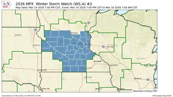
TWIN CITIES, MINNESOTA: The National Weather Service Twin Cities has issued a Winter Storm Watch for a large portion of Minnesota as forecasters track a potentially major winter storm expected to impact the region from Saturday evening through Monday morning.
The system could bring heavy snowfall, strong winds, and hazardous travel conditions across much of the state, with the potential for 10 to 20 inches of snow in some areas. The Winter Storm Watch includes central, east-central, south-central, southeast, southwest, and west-central Minnesota. The storm is expected to develop Saturday evening and continue through Sunday, then gradually taper off early Monday morning. The system will move across the Upper Midwest Saturday into Sunday, producing a broad and intense precipitation shield capable of generating significant snowfall totals.
Potential Snowfall Totals
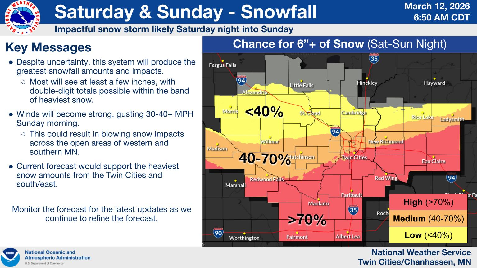
Current forecast guidance suggests widespread snowfall across the watch area, with:
6 to 10 inches of snow is likely across much of the region
Localized totals exceeding 12 inches, especially across portions of southeastern Minnesota and western Wisconsin
Some locations potentially seeing 10 to 20 inches if heavier snow bands develop
The latest forecast models continue to show a remarkably large precipitation footprint, meaning heavy snow could impact a large geographic area rather than isolated pockets. Because the storm is still several days away, snow totals could shift depending on the system's exact track, and forecasters expect updates in the coming days.
Strong Winds Could Create Blizzard-Like Conditions
In addition to heavy snow, strong winds are expected to accompany the storm.
Wind gusts could reach up to 45 mph
Blowing and drifting snow could significantly reduce visibility
Near-blizzard conditions may develop at times on Sunday
The combination of falling snow and strong winds may produce whiteout conditions in open areas, particularly in rural locations.
Travel Could Become Extremely Dangerous
Travel conditions could deteriorate rapidly once snowfall intensifies.
Potential impacts include:
Very difficult or impossible travel
Blowing snow reducing visibility
Snow-covered and icy roadways
Possible tree branch damage from strong winds
The storm may also impact the Monday morning commute, depending on how quickly snow tapers off Sunday night.
Provided by the NWS Twin Cities.
Prepare Now
The National Weather Service is encouraging residents to closely monitor forecast updates as the storm approaches.
Preparation steps may include:
Checking travel plans for the weekend
Preparing emergency winter kits for vehicles
Ensuring snow removal equipment is ready
Securing outdoor items that could be blown around by strong winds
A Winter Storm Watch means conditions are favorable for significant winter weather, but the exact timing and snowfall totals will become clearer over the next few forecast updates. If current projections hold, the system could become one of the more significant late-season snowstorms of the winter for parts of Minnesota.
Updates and potential upgrades to Winter Storm Warnings are expected as the storm draws closer.