
High Wind Watch Issued for Twin Cities and Southern Minnesota; Gusts up to 60 mph Possible Late Thursday Night into Friday
Issued by the NWS Twin Cities at 12:47 pm on Wednesday, March 11, 2026.
Published: March 11, 2026
TWIN CITIES, MINNESOTA: Residents across the Twin Cities metro and much of southern Minnesota are being urged to prepare for potentially damaging winds later this week, as a powerful weather system could bring wind gusts approaching 60 mph beginning late Thursday night.
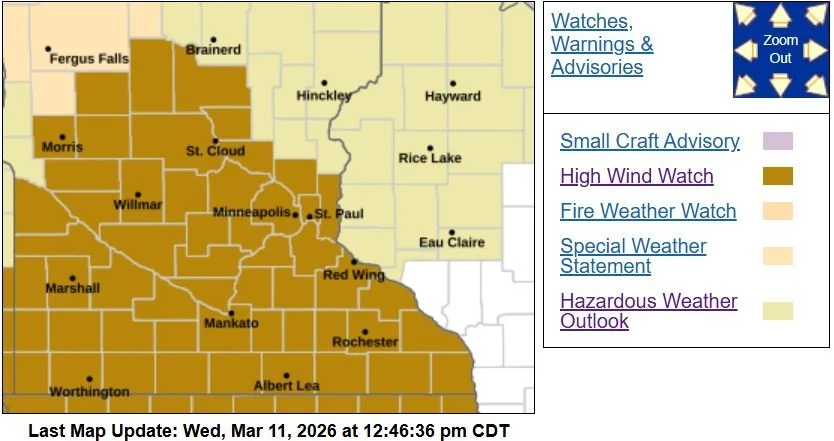
The National Weather Service in the Twin Cities has issued a High Wind Watch covering a wide area of central and southern Minnesota, including Anoka, Carver, Dakota, Hennepin, Ramsey, Scott, Washington, Wright, Benton, Morrison, Sherburne, Le Sueur, Rice, Steele, and Goodhue counties.
Strong Winds Expected Late Thursday Through Friday Morning
According to the latest guidance, northwest winds of 25 to 35 mph are expected to develop as the storm system works into the Upper Midwest, with gusts potentially reaching 60 mph in some areas. The strongest winds are expected late Thursday night through Friday morning, though gusty conditions could continue into Friday afternoon.
These winds will be driven by a rapidly strengthening area of low pressure tracking near the U.S.–Canada border, which will tighten the pressure gradient across Minnesota as it moves east toward the Great Lakes. As the system deepens, stronger winds are expected to develop on the storm's backside.
Potential Impacts
If the stronger wind gusts materialize, several impacts could be seen across the region, including:
Downed trees and power lines
Localized or widespread power outages
Difficult travel conditions, especially for high-profile vehicles such as trucks and buses
Blowing debris in open areas
It is recommended to begin preparing for these potentially strong winds now by bringing loose outdoor items, such as patio furniture, garbage bins, and decorations, indoors ahead of the storm.
Rain and Snow Expected Before Winds Increase
Before the strongest winds arrive, the region is expected to experience a mixed precipitation event Thursday into Thursday night.
The latest guidance shows light snow may begin late Thursday morning, but warmer temperatures will likely cause much of the precipitation to change over to rain during the afternoon and evening across much of Minnesota. By later Thursday night, precipitation may briefly switch back to light snow before ending as colder and drier air moves in behind the storm.
Total snowfall amounts are expected to remain generally under one inch across most of the area, though parts of western Wisconsin could see 1–2 inches.
Another Storm Could Bring Weekend Snow
We continue to monitor a potentially more significant winter storm expected to develop later this weekend.
Current guidance suggests that a low-pressure system, often known as a Colorado-Clipper, will develop out of Colorado and could track south of Minnesota, placing the Upper Midwest in a zone favorable for heavier snowfall from late Saturday into Sunday.
At this time, southern Minnesota appears most likely to receive the highest snow totals, but there remains considerable uncertainty about the storm's exact track, speed, and the amount of moisture available.
With multiple weather systems expected over the coming days, please continue to monitor for the latest forecast updates and any potential warnings. With the upcoming wind threat, again, the time to prepare is now:
Secure outdoor items ahead of strong winds
Charge electronic devices in case of power outages
Use caution while driving during high winds or mixed precipitation
Additional updates are expected over the coming days!