
Enhanced Severe Weather Risk Monday Across Twin Cities; Large Hail, Damaging Winds, Isolated Tornado, and Flash Flooding Possible
Published: April 12, 2026. | Last Updated: April 13, 2026, at 10 am.
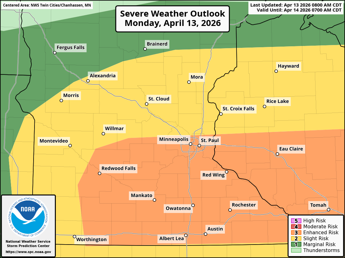
TWIN CITIES, MINNESOTA: Residents across the Twin Cities and surrounding areas should prepare for an increasing threat of severe weather this afternoon (Monday) and into the evening, including large hail, damaging winds, heavy rainfall, and isolated tornadoes.
While the Storm Prediction Center has shifted the enhanced threat south a bit, the Twin Cities metro remains under the Enhanced Risk (Level 3 of 5) for severe thunderstorms.
Timing and Overview
Based on the latest model guidance, the primary window for severe weather in the Twin Cities is expected:
Monday afternoon: After 3 PM
Peak threat: Late afternoon into the evening
Ending: Around 10 PM, with storms gradually weakening and ending overnight
A warm front will be the focal point for storm development, with conditions becoming increasingly favorable for strong-to-severe thunderstorms as the day progresses and instability increases. The threat times are still subject to change, so please continue to check for the latest updates.
Main Threats
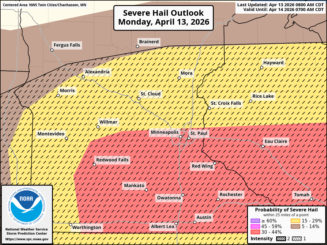
Large to Very Large Hail (Primary Threat)
The biggest concern with Monday’s storms is the potential for large to very large hail, possibly 2-3 inches in diameter.
This weather setup is forecast to bring strong atmospheric instability (MLCAPE over 2000 J/kg), thanks to ample moisture and warm temperatures, which will combine with favorable wind shear in the region to support supercell thunderstorms capable of producing destructive hail, which can damage roofs, vehicles, and windows in a matter of minutes.
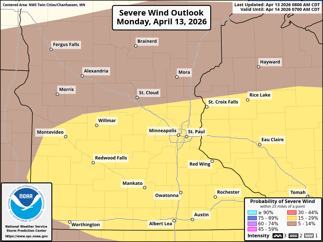
Damaging Winds
While the primary threat early on will be large to very large hail with any discrete supercells that might develop, these are forecast to eventually organize and potentially form bowing segments, which will shift the risk to damaging straight-line winds.
These strong wind gusts could down trees and power lines. cause localized structural damage. amd dead to scattered power outages during the evening commute.
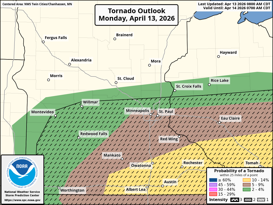
Isolated Tornado Risk
While the tornado threat is lower than that of hail and wind, it is not zero. If any of the early storms and supercells become surface-based near the frontal boundary (across southern Minnesota), conditions may support a few tornadoes, which could be strong in isolated cases, thanks to enhanced rotation driven by favorable low-level wind shear. This will also support the threat of large to very large hail. Across the Twin Cities metro, embedded tornadoes in the line (QLCS tornadoes) are possible. These tend to be weaker, but can develop quickly!
This risk will depend heavily on how storms evolve this afternoon.
Heavy Rain & Localized Flash Flooding
In addition to severe storms, heavy rainfall will be a significant concern, especially across the Twin Cities Metro, where repeated storms (training thunderstorms) will be possible.
Impacts may include localized flash flooding, particularly in urban and low-lying areas, reduced visibility during heavy downpours, and water-covered roads during the evening commute, which could lead to hydroplaning. This could be especially true when driving through any of the various work zones across the Metro, which might have poor drainage.
What’s Driving This Setup
As we previously mentioned, a combination of key ingredients will come together on Monday (today) to support this severe weather setup. Those include increasing moisture levels, with dew points rising into the 60s, a strong low-level jet stream that is aiding the surge of moisture into the region, which will help storms rapidly intensify.
Often in these setups, a capping inversion, which we’ve mentioned in previous weather discussions as the cap, helps build energy early in the day into the afternoon before storms erupt. You can think of the cap as the lid on a soda bottle. If you shake up that bottle (build up energy or CAPE), but don’t open the lid, nothing happens. As soon as you open the lid, though, the soda explodes. For the weather, you need a forcing mechanism or trigger to break that cap; in this case, it will be the front tied to the upper-level disturbance, which will provide enough lift to break the cap and allow storms to develop during the afternoon, potentially becoming explosive.
Depending on how strong that cap is, it could also play a role in how long storms remain isolated or how quickly they develop into organized lines, which raises questions about the uncertainty of this setup.
Uncertainty Remains
As is often the case in these setups, there are a number of uncertainties that can affect the timing, storm coverage, and severity of a weather setup, and often result in claims that it is a potential bust.
Key factors include:
Exactly when storms initiate
Whether storms remain isolated supercells or quickly organize into lines
How far west do stronger storms develop in Minnesota versus Wisconsin
Even with these uncertainties, confidence is increasing that at least some strong-to-severe storms will impact the Twin Cities area.
What You Should Do
As with any severe weather setup, the following are some important things you can do NOW, ahead of the threat tomorrow:
Stay weather-aware Monday afternoon and evening, be sure to continue to check the latest forecast for any changes in timing and severity of storms
Have multiple ways to receive warnings (weather apps, alerts, NOAA radio)
Move vehicles indoors if possible due to hail risk, and bring in or secure any loose items you might have around your home or residence
Avoid flooded roadways. Turn Around, Don’t Drown
Be prepared to seek shelter quickly if warnings are issued
This marks the beginning of a more active weather pattern across the region this week!