
Parts of Southern Twin Cities Metro Upgraded to Winter Storm Warning as Icy Mix Moves In
Published: April 1, 2026.
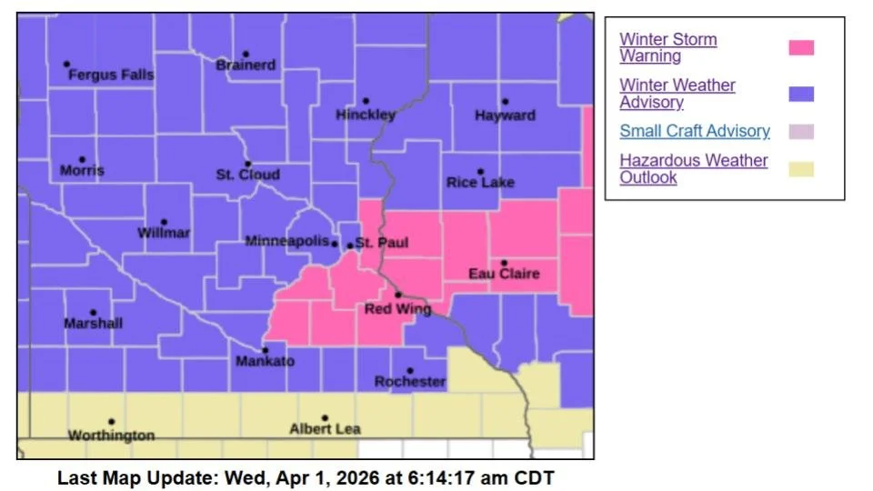
TWIN CITIES, MINNESOTA: A messy spring storm is set to bring a dangerous mix of freezing rain, sleet, and snow across Minnesota and western Wisconsin beginning late Wednesday night, prompting the National Weather Service to upgrade portions of the southern Twin Cities metro to a Winter Storm Warning, while the rest of the metro remains under a Winter Weather Advisory.
Warning vs. Advisory: Who’s Impacted
The Winter Storm Warning is in effect from midnight through noon Thursday for parts of the southern and eastern Twin Cities metro, including:
Dakota County
Scott County
Washington County
Le Sueur, Rice, and Goodhue counties
Meanwhile, the broader metro, including Minneapolis, St. Paul, and surrounding counties, remains under a Winter Weather Advisory during the same timeframe.
What to Expect
Forecasters say this system will not be a simple snowstorm. Instead, it will bring acomplex mix of precipitation types, with conditions varying significantly across the region.
In the warning area, the most severe impacts are expected, including:
Up to 0.25 inches of ice accumulation
Around 0.75 inches of sleet
Up to 1 inch of snow
Wind gusts up to 30 mph
Across the advisory area, slightly lower, but still impactful, totals are expected:
Up to 0.2 inches of ice
Around 0.5 inches of sleet
Up to 1 inch of snow
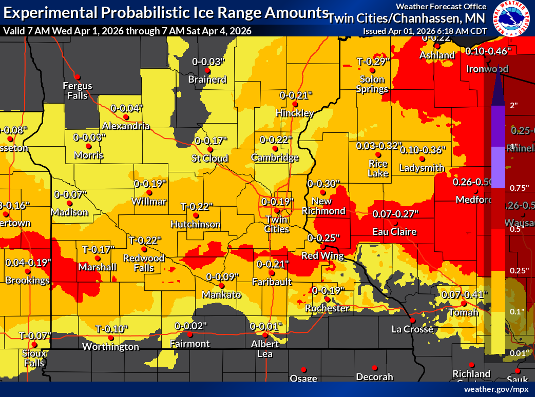
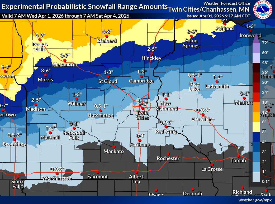
Accumulation maps provided by the NWS Twin Cities.
Travel Conditions Expected to Deteriorate Overnight
The timing of this system is expected to create significant travel concerns.
Precipitation begins late Wednesday evening, with freezing rain and sleet developing around midnight
The worst conditions are expected overnight into Thursday morning
Roads, bridges, and overpasses are expected to become slick and hazardous
The Thursday morning commute across the Twin Cities metro could be especially dangerous due to widespread icy conditions.
Ice Could Bring Power Outages
In areas under the Winter Storm Warning, ice accumulation may be enough to:
Weigh down tree branches
Cause isolated power outages
Lead to falling limbs in some areas
Forecasters note that even outside the warning area, a glaze of ice combined with sleet will still create hazardous conditions.
Why the Upgrade Was Issued
The upgrade to a Winter Storm Warning comes as confidence has increased in higher ice accumulation totals, particularly across eastern Minnesota.
Recent forecast guidance trends showed a greater potential for freezing rain than previously expected, with ice amounts nearing 0.25 inches, which can significantly increase impacts. Additionally, a shifting storm track northward favors more icing in the southern metro
However, small changes in temperature and storm track could still affect how much ice versus sleet falls in any given location.
Conditions Improve Later Thursday
Temperatures are expected to rise above freezing by late Thursday morning into the afternoon, which should help gradually melt ice on roadways, before ultimately transitioning precipitation to rain across the south metro areas and reducing overall travel hazards later in the day.
However, some slick spots may linger into Thursday afternoon, especially on untreated surfaces.
Another Round of Winter Weather Possible
This system won’t be the last. Another storm is expected to move into the region Friday night into Saturday, bringing the chances for additional precipitation.
The potential for accumulating snow is highest across northern Minnesota, but the details on that system are still evolving.
Safety Reminders
Officials urge residents to:
Slow down and allow extra travel time
Use caution on sidewalks and driveways
Keep an emergency kit in vehicles if traveling overnight
For the latest road conditions, drivers can call 511 or visit the 511 website: https://511mn.org/.
