
Severe Thunderstorms Bring Large Hail, Strong Winds, and Hazardous Travel Conditions Across the Twin Cities Metro
Published: June 19, 2026
TWIN CITIES, MINNESOTA - Severe thunderstorms swept across the Twin Cities metropolitan area Friday afternoon and evening, June 19, bringing large hail, damaging winds, frequent lightning, power outages, and dangerous travel conditions, prompting numerous motorists to seek shelter beneath highway overpasses.
The storms developed in an environment conducive to severe weather, with forecasters warning of the potential for significant hail and damaging winds across eastern Minnesota and western Wisconsin as early as the late morning on Friday, when the Storm Prediction Center upgraded a large portion of central Minnesota and western Wisconsin to a Slight Risk (2/5), for damaging large hail and gusty winds.
Severe Thunderstorm Watch Issued
Just before 2:00 PM, the National Weather Service's Storm Prediction Center issued a Severe Thunderstorm Watch for portions of central and eastern Minnesota and western Wisconsin.
The watch warned that the strongest storms could produce:
Hail up to 2 inches in diameter
Isolated wind gusts up to 65 mph
Frequent lightning
Heavy rainfall
As the afternoon progressed, thunderstorms intensified across central Minnesota and began moving southeast toward the Twin Cities metro.
First Weather Alerts Issued for Northwestern Metro
The first weather alerts affecting the Twin Cities metro were issued around 4:22 PM, when the National Weather Service released a Special Weather Statement for portions of northwestern Hennepin County, including Rogers, Coon Rapids, Brooklyn Park, Crystal, and Saint Anthony, warning residents of thunderstorms capable of producing:
Wind gusts up to 40 mph
Penny-sized hail
Brief heavy rainfall
Just one minute later, at approximately 4:23 PM, a second Special Weather Statement was issued for East Bethel, Oak Grove, and Wyoming, Minnesota, with similar warnings about strong winds and hail.
Warnings Expand Across Minneapolis and Saint Paul
By approximately 4:40 PM, conditions had intensified enough for the National Weather Service to upgrade the initial statement to a Severe Thunderstorm Warning.
The warning expanded east and south, covering much of the Twin Cities metro, including Minneapolis, Saint Paul, Shoreview, Little Canada, Roseville, and portions of northern Dakota County.
The warning was for:
Wind gusts up to 60 mph
Quarter-sized hail
Dangerous cloud-to-ground lightning
Torrential rainfall
As the storm complex continued moving eastward, the warning was extended again around 5:28 PM to include Woodbury, Oak Park Heights, Afton, and Hudson, Wisconsin.
Large Hail Pummels Parts of the Metro
One of the most significant impacts from Friday's storms was widespread large hail across the metro area. According to reports received by the National Weather Service in Chanhassen, several dozen hail reports were submitted from communities throughout the Twin Cities.
Reported hail sizes ranged from approximately 1 inch to as large as 2.25 inches in diameter, with some of the largest hail reported in:
Northeast Saint Paul
Falcon Heights
Roseville
Maplewood
Little Canada
Numerous other communities reported hail ranging from 1 to 1.75 inches in diameter, large enough to damage vehicles, roofing materials, siding, and vegetation.
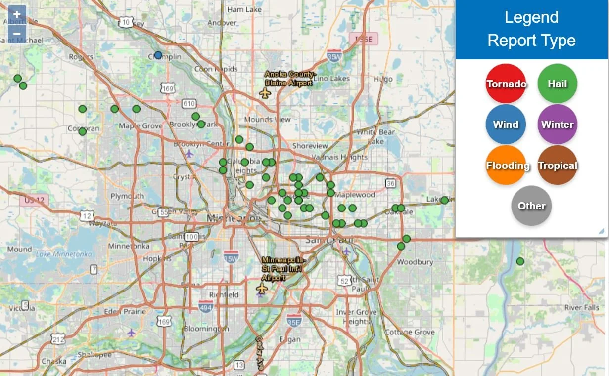
National Weather Service 24-hour Storm Reports.
Drivers Stop Under Overpasses as Hail Falls
As reports of large hail spread across the metro, many motorists attempted to protect their vehicles by stopping beneath highway overpasses and bridges. Minnesota Department of Transportation (MnDOT) traffic cameras captured numerous instances of vehicles parked underneath overpasses throughout the Twin Cities during the height of the storm.
In several locations, vehicles completely blocked travel lanes while seeking shelter from the hail, creating dangerous conditions for other motorists.
Safety Warning: Do Not Stop Under Highway Overpasses
Authorities strongly discourage drivers from stopping beneath highway overpasses during severe weather events. While some motorists may seek shelter from hail damage, stopping under bridges can create significant hazards for other drivers and emergency responders.
Vehicles parked beneath overpasses can block travel lanes, force other motorists to make sudden maneuvers, increase the risk of rear-end and secondary crashes, and impede access for emergency vehicles. In some cases, traffic backups created by stopped vehicles can extend into active travel lanes, creating dangerous conditions during already hazardous weather.
Safety officials recommend that motorists continue driving cautiously and, if conditions become unsafe, exit the highway and seek shelter at a safe location such as a gas station, parking ramp, or other sturdy structure. Drivers should never stop in active traffic lanes or beneath highway overpasses to avoid hail.

Screenshot from the video at the top of the article showing vehicles seeking shelter under a highway overpass and completely blocking the highway as large hail fell across the northeast Twin Cities metro on Friday evening.
South Metro Sees Wind Damage and Power Outages
While the largest hail reports were concentrated across portions of the northern and eastern metro, communities in the south metro experienced strong winds and scattered storm damage as the system continued southward.
Just after 6:00 PM, the National Weather Service issued a large Special Weather Statement covering portions of Dakota, Scott, and surrounding counties, warning of wind gusts up to 50 mph as scattered showers and thunderstorms moved through the area.
By approximately 6:50 PM, emergency dispatchers across the south metro were receiving numerous reports of downed power lines and wires as stronger wind gusts began causing localized damage from downed trees and branches.
The storms also led to widespread power outages across Minnesota. Just before 7:00 PM, Xcel Energy's outage map showed more than 20,000 customers without power as severe weather moved across the state. Utility crews were expected to work through the evening to restore service to affected neighborhoods.
Peak Wind Gusts Across the Twin Cities Metro
While hail generated much of the attention during Friday's event, weather stations across the metro also recorded impressive wind gusts.
According to observation data, some of the highest measured gusts included:
58 mph near Minnetonka
52 mph near Waconia
48 mph west of the metro
48 mph near downtown Minneapolis
45 mph near Inver Grove Heights
45 mph in southern Dakota County
44 mph near Belle Plaine
42 mph near Shakopee
41 mph in the northern metro
40 mph near Lakeville
Most observation sites across the metro recorded wind gusts ranging from 20 to 40 mph, with the strongest winds generally occurring in portions of the western and northern Twin Cities.
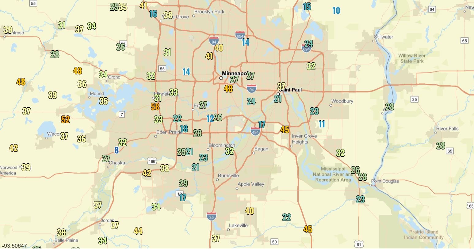
National Weather Service Max Wind Gust Reports (MPH) across Twin Cities Metro as of 9:30 PM.
Storm Threat Ends Across the Metro
As the thunderstorms pushed east and southeast of the metropolitan area during the evening hours, conditions gradually improved.
By 8:00 PM, the severe weather threat had effectively ended across the Twin Cities metro as the strongest storms exited the region and instability diminished.
Although scattered showers lingered in some areas, the risk for severe hail and damaging winds had come to an end.
Cleanup and Damage Assessments Continue
Residents across the Twin Cities spent Friday evening assessing damage from hail, wind, lightning, and fallen tree limbs. While widespread structural damage was not immediately reported, the combination of hail up to 2.25 inches in diameter, wind gusts approaching 60 mph, downed wires, and thousands of power outages made Friday's storms one of the most impactful severe weather events to affect the metro so far this summer.
The National Weather Service continues collecting storm reports and may update official storm summaries as additional information becomes available.
Written by: Will Wight