
Back-to-Back Storms Soak Twin Cities Metro, Trigger Flash Flood Warning, and Disrupt Fourth of July Celebrations
Published: July 5th, 2026 | Last Updated: July 5, 2026 at 2:30 PM.
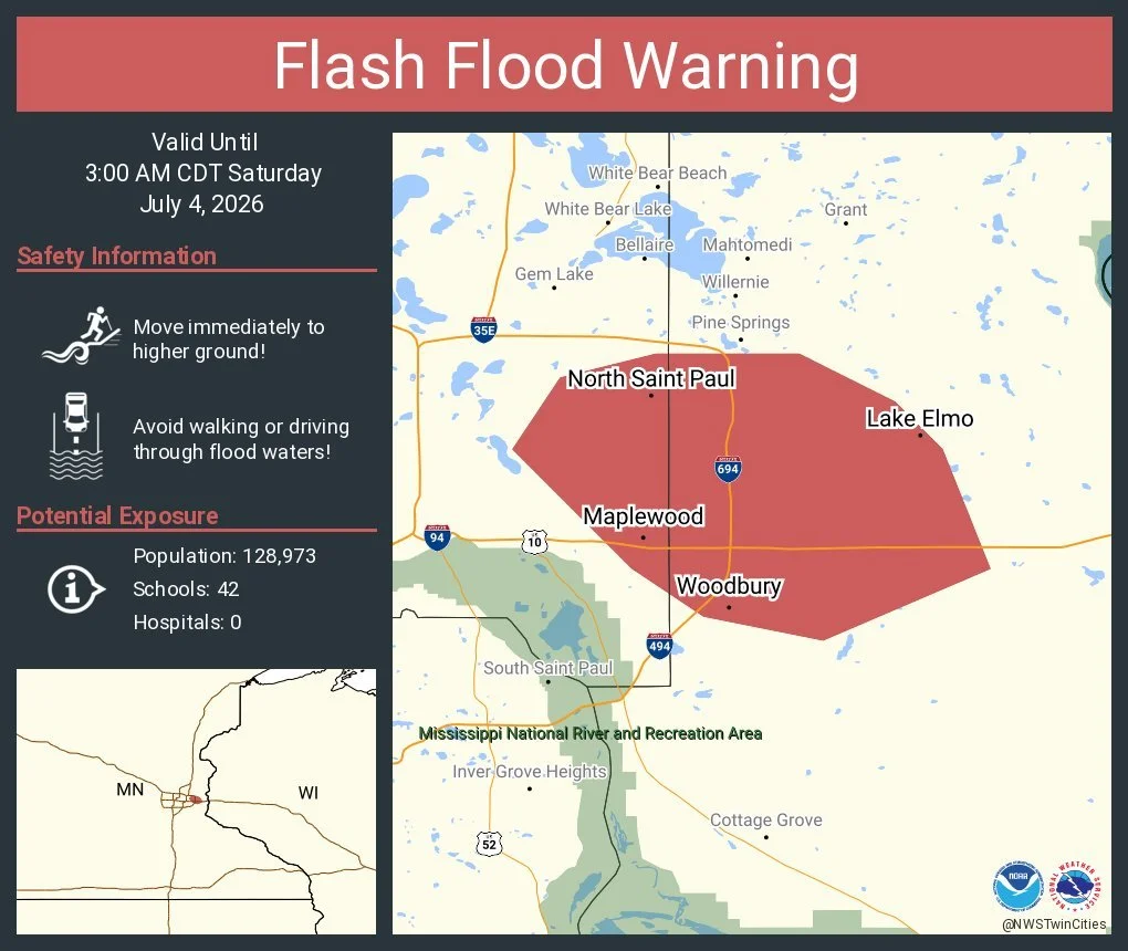
TWIN CITIES, MINNESOTA - Two consecutive days of scattered heavy rain and strong thunderstorms drenched the Twin Cities metro over the Independence Day holiday weekend, bringing several inches of rainfall to some communities, prompting a Flash Flood Warning on July 3 across parts of the northeast Metro, and forcing delays or cancellations of several Fourth of July fireworks displays on July 4th.
The storms also produced strong wind gusts of 25-45 mph, damaging fireworks equipment and event infrastructure and creating unsafe conditions for outdoor celebrations across the region.
July 3: Heavy Rain Prompts Flash Flood Warning
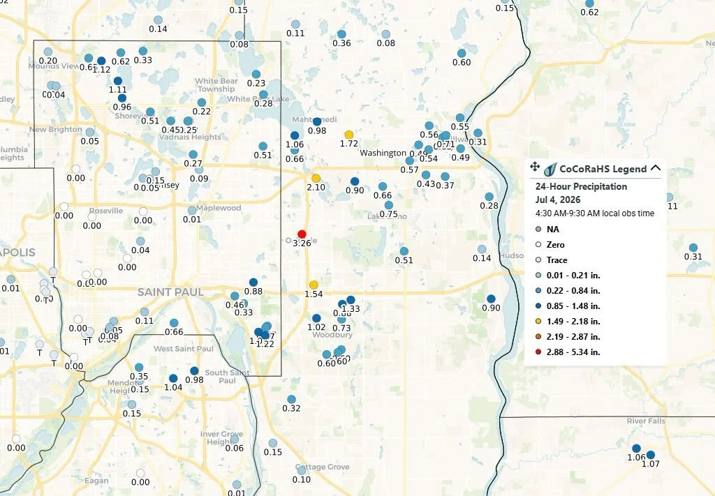
A round of storms moved through the Twin Cities late on Friday, July 3, dropping approximately 1.0 to 4.25 inches of rain in parts of the metro, according to the Community Collaborative Rain, Hail & Snow Network (CoCoRaHS) and reports Limitless Media News received.
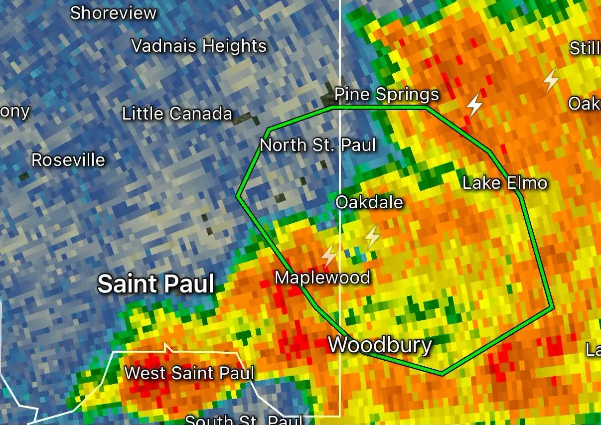
The intense rainfall led the National Weather Service to issue a Flash Flood Warning for portions of the east metro, including North Saint Paul, Maplewood, Oakdale, Woodbury, and Lake Elmo.
Localized street flooding and rapidly rising water were reported in some areas as the heaviest rain fell during the evening hours.
July 4: More Rain and Strong Winds
A second round of scattered thunderstorms developed on Saturday, July 4, bringing another widespread swath of rainfall across much of the metro.
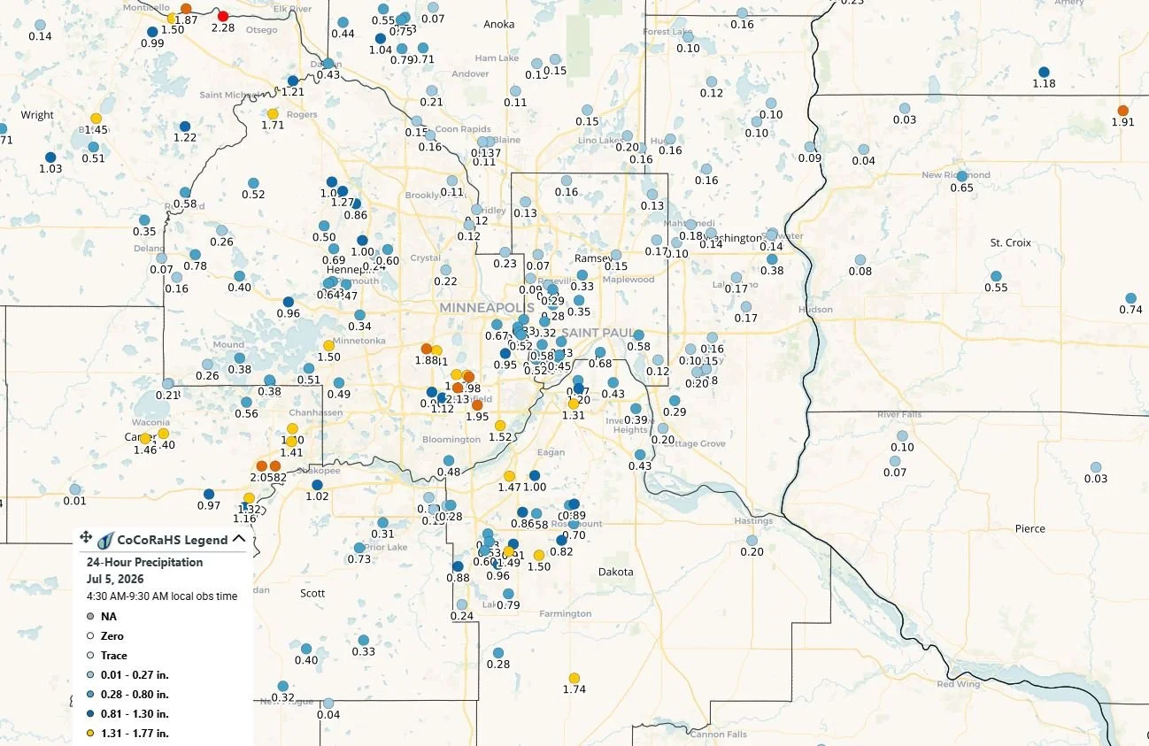
Rainfall reports collected through the CoCoRaHS show most communities received between 0.25 and 2 inches of rain, while isolated locations measured even higher totals.
Some of the highest rainfall totals on the July 5 CoCoRaHS map included:
1.82-2.20 inches near Chaska
1.45-1.50 inches across Eagan, Apple Valley, and Lakeville
1.74 inches near Northfield
1.95 inches in Richfield
Numerous reports between 1 and 2 inches across the remainder of Dakota, Scott, Hennepin, Ramsey, and Carver counties
Many other locations across the metro reported between 0.5 and 1 inch of rainfall.
Repeated rainfall over saturated ground created additional standing water in low-lying areas, while gusty winds complicated outdoor holiday events.
Storm Damage Impacts Fireworks Celebrations
While many communities had hoped to proceed with their Independence Day fireworks displays, Saturday evening's storms forced organizers to delay, cancel, or closely monitor conditions.
Prior Lake
The Prior Lake Association announced that its fireworks show was canceled after strong winds damaged protective coverings on many of the fireworks devices.
"Regretfully, tonight's show is canceled. The winds damaged protective coverings on many of the devices. The crew is working to restore the affected materials. We will have an update at 10 AM tomorrow."
They have rescheduled these fireworks for 10 PM tonight, Sunday, July 5, 2026, at Watzl’s Beach.
Eagan
Eagan's FunFest also canceled its fireworks after storm damage affected both the fireworks setup and the main event stage. Around 9 AM, organizers further mentioned that these will not be rescheduled for tonight, Sunday, July 5th.
Organizers announced:
"Unfortunately tonight's fireworks show has been cancelled due to the damage they sustained during the storm. The Funfest stage also took a hit which means the band won't be able to continue tonight. Very sorry for the cancellations."
Lakeville
Lakeville officials initially announced that the Pan-O-Prog fireworks would proceed at 10 p.m., provided lightning remained out of the area. However, as storms lingered, organizers issued an update at 8:55 p.m., canceling the display.
Officials have announced these have been rescheduled for Sunday, July 12, 2026.
Apple Valley
Apple Valley's Freedom Days fireworks were postponed until 10:30 p.m., allowing storms to move through before the celebration resumed. A batch of moderate rain that ended just before the fireworks began made several wonder whether they would still happen, but they did, and several came to enjoy the show from across the region!
Hastings
The Hastings Golf Club & Events fireworks were delayed until 10:15 p.m. because of lightning in the area.
Looking Ahead: Another Round of Storms Possible Tuesday
After a brief break from the active weather pattern, storm chances are expected to return Tuesday evening and continue into the overnight hours. We are monitoring the potential for another round of severe thunderstorms and heavy rainfall across Minnesota and western Wisconsin, as a complex of thunderstorms is expected to develop across central and southern Minnesota Tuesday evening, then track east into western Wisconsin overnight.
At this time, the primary threats include:
Damaging wind gusts
Torrential rainfall that could lead to localized flooding
Frequent lightning
Much of southern and western Minnesota is currently under a Level 2 (Slight Risk) for severe weather, while eastern portions of the Twin Cities metro, including parts of Dakota County, remain under a Level 1 (Marginal Risk).
In addition, much of central and southern Minnesota is included in a Level 2 (Slight Risk) for excessive rainfall, indicating another chance for heavy downpours capable of producing localized flash flooding, especially in areas that have already received several inches of rain over the past several days.
There is still some uncertainty regarding the exact track of Tuesday night's storm complex, which will determine where the heaviest rain and strongest storms ultimately occur.
Residents are encouraged to monitor the latest forecasts over the next couple of days, particularly those with outdoor plans Tuesday evening, as additional watches or warnings may become necessary. If you are interested in becoming a CoCoRaHS observer, you can check out their website to learn more and sign up to be an observer here: https://www.cocorahs.org/
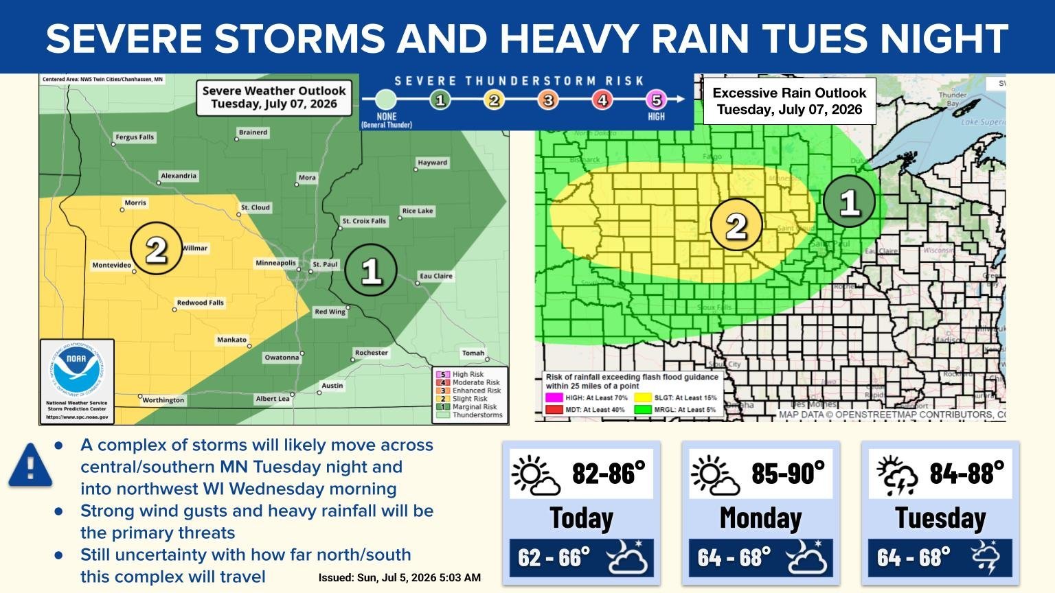
Provided by the NWS Twin Cities.
Written by: Will Wight
