
Severe Thunderstorm Watch Issued for Much of Central and Southern Minnesota, Western Wisconsin Until 11 P.M.
Published: June 5, 2026
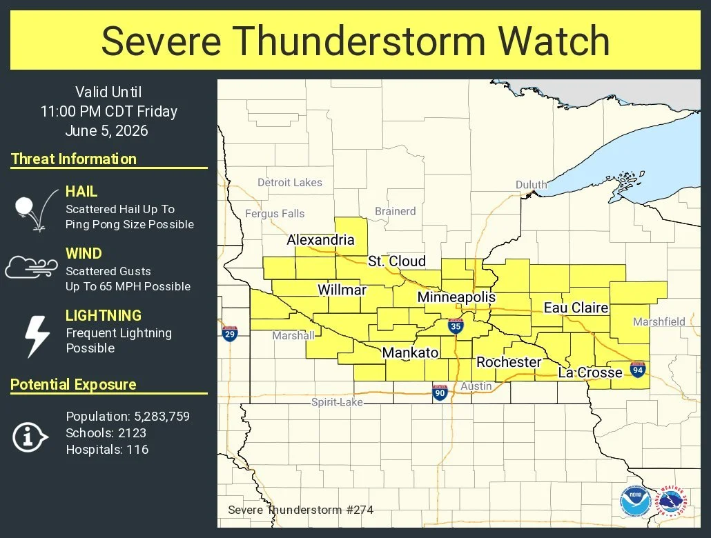
TWIN CITIES, MINNESOTA: A Severe Thunderstorm Watch has been issued for portions of central and southern Minnesota and western Wisconsin and remains in effect until 11 p.m. CDT Friday, June 5, 2026, as conditions become favorable for the development of severe thunderstorms across the region.
The watch, issued by the Storm Prediction Center, includes much of the Twin Cities metropolitan area and surrounding communities stretching from western Minnesota eastward into western Wisconsin.
According to the watch, storms that develop this afternoon and evening may produce:
Hail up to ping pong ball size
Wind gusts up to 65 mph
Frequent cloud-to-ground lightning
Heavy rainfall and localized flooding in stronger storms
Millions Under the Watch Area
The watch covers a large portion of the Upper Midwest, including the Twin Cities, St. Cloud, Mankato, Rochester, Alexandria, Willmar, Eau Claire, and surrounding communities.
The National Weather Service estimates the watch area includes:
More than 5.2 million residents
2,123 schools
116 hospitals
Storms Expected Through the Evening
Meteorologists have been monitoring an increasingly unstable atmosphere across Minnesota and Wisconsin throughout the day. Warm temperatures, abundant moisture, and an approaching weather disturbance are expected to fuel thunderstorm development during the afternoon and evening hours.
Earlier forecasts indicated that portions of central Minnesota and west-central Wisconsin could see the strongest storms, with atmospheric conditions conducive to large hail and damaging winds.
While the overall tornado threat remains relatively low, forecasters caution that a few stronger storms could briefly become severe before evolving into clusters or line segments capable of producing widespread strong wind gusts.
What a Severe Thunderstorm Watch Means
A Severe Thunderstorm Watch means that conditions are favorable for severe thunderstorms to develop in and near the watch area. It does not mean severe weather is occurring everywhere within the watch area.
Residents should:
Monitor weather forecasts and alerts throughout the evening.
Have multiple ways to receive warnings, including Wireless Emergency Alerts and NOAA Weather Radio.
Be prepared to move indoors quickly if a Severe Thunderstorm Warning is issued.
Secure outdoor furniture, tents, and other loose objects that could become airborne in strong winds.
Avoid open areas and seek shelter immediately if lightning is observed.
Stay Weather Aware
Storms are expected to move across the region through the evening before gradually exiting later tonight. Residents across Minnesota and western Wisconsin are encouraged to remain weather-aware and be prepared for rapidly changing conditions.
Limitless Media will continue to monitor the situation and provide updates if severe thunderstorm warnings or significant storm reports are issued across the region.
Watch Details
Type: Severe Thunderstorm Watch #274
Issued For: Portions of Minnesota and Wisconsin
Valid Until: 11:00 p.m. CDT Friday, June 5, 2026
Primary Threats: Ping-pong-ball-size hail, wind gusts up to 65 mph, frequent lightning.
Additional Reading: Twin Cities Area Upgraded to Slight Risk for Severe Weather Today; Large Hail and Damaging Winds Possible