
Severe Thunderstorm Watch Issued for Dakota County and Portions of Southeast Minnesota Until 8 PM Wednesday
Published: June 17, 2026
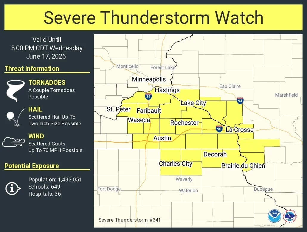
TWIN CITIES, MINNESOTA: The Storm Prediction Center has issued a Severe Thunderstorm Watch, which is in effect until 8:00 PM CDT Wednesday, June 17, 2026, for Dakota County and several counties across southern and southeastern Minnesota.
The watch includes the following Minnesota counties:
Dakota
Dodge
Fillmore
Freeborn
Goodhue
Houston
Le Sueur
Mower
Olmsted
Rice
Scott
Steele
Wabasha
Waseca
Winona
According to the Storm Prediction Center, conditions are favorable for the development of severe thunderstorms capable of producing damaging winds, large hail, and isolated tornadoes this afternoon and evening.
Forecasters indicate the primary threats include:
Scattered wind gusts up to 70 mph
Scattered hail up to 2 inches in diameter
A couple of tornadoes possible
The watch area includes much of the Rochester region, portions of the I- 35 corridor, and communities along the Mississippi River Valley. Dakota County, including communities such as Apple Valley, Burnsville, Eagan, Farmington, Hastings, Lakeville, Mendota Heights, Rosemount, South St. Paul, and West St. Paul, are included in the watch.
A severe thunderstorm watch means atmospheric conditions are favorable for severe thunderstorms to develop. Residents should remain alert for rapidly changing weather conditions and be prepared to take action if warnings are issued later today.
The Storm Prediction Center estimates that more than 1.4 million people are within the watch area, along with 649 schools and 36 hospitals.
Earlier forecasts highlighted the potential for strong-to-severe storms to develop during the afternoon hours as instability increases across southern Minnesota. While widespread severe weather is not guaranteed, any storms that do form could quickly intensify and cause damaging impacts.
Residents are encouraged to:
Monitor weather alerts throughout the afternoon and evening.
Have multiple ways to receive warnings, including Wireless Emergency Alerts and NOAA Weather Radio.
Secure loose outdoor objects that could become airborne in strong winds.
Move indoors immediately if a Severe Thunderstorm Warning or Tornado Warning is issued for your area.
Additional watches, warnings, or advisories may be issued as thunderstorms develop across the region.