
Scattered Storms Possible Today Before Cooler, Dry Weekend Settles Into the Twin Cities
Published: June 12, 2026
TWIN CITIES, MINNESOTA: Twin Cities and much of Minnesota can expect one more opportunity for showers and thunderstorms this afternoon and evening before a stretch of cooler, drier weather settles into the region for the weekend and into next week. Scattered showers and thunderstorms are expected to develop this afternoon as a cold front moves south from Canada and crosses the region.
Storms Could Produce Hail and Strong Wind Gusts
Today starts out with mostly sunny skies and cool morning temperatures. Sunshine is expected through the remainder of the morning and into the early afternoon, helping temperatures climb into the upper 70s to around 80 degrees across much of the Twin Cities metro. However, weather conditions will begin to change later in the day as the previously mentioned cold front moves east across the Dakotas and into Minnesota. Combined with the approaching cold front, the setup will be favorable for scattered thunderstorm development during the afternoon and evening hours. Across the Twin Cities, it appears this activity will arrive around and after 7-8 PM.
While widespread severe weather is not expected, a few stronger storms could develop, with storms may be capable of producing:
Hail
Strong to locally severe wind gusts
Brief periods of heavy rainfall
Frequent lightning
The greatest potential for stronger storms appears to be across central Minnesota and western Wisconsin, though isolated stronger storms could impact portions of the Twin Cities metro as well. Residents with outdoor plans this afternoon or evening, for example, going to the Twins game tonight, are encouraged to monitor forecasts and be prepared to move indoors if thunderstorms approach.
Recent Rainfall Provides Welcome Relief, But Drought Concerns Remain
The Twin Cities and surrounding areas have received beneficial rainfall over the past week, helping ease dry conditions that have developed across portions of Minnesota this spring.
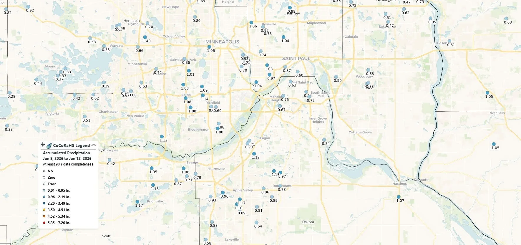
According to Community Collaborative Rain, Hail and Snow Network (CoCoRaHS) observations, most locations across the Twin Cities metro recorded between 0.50 and 1.20 inches of rainfall between June 8 and June 12. Some communities reported totals exceeding one inch, including portions of the south metro, while a few isolated areas received less than half an inch.
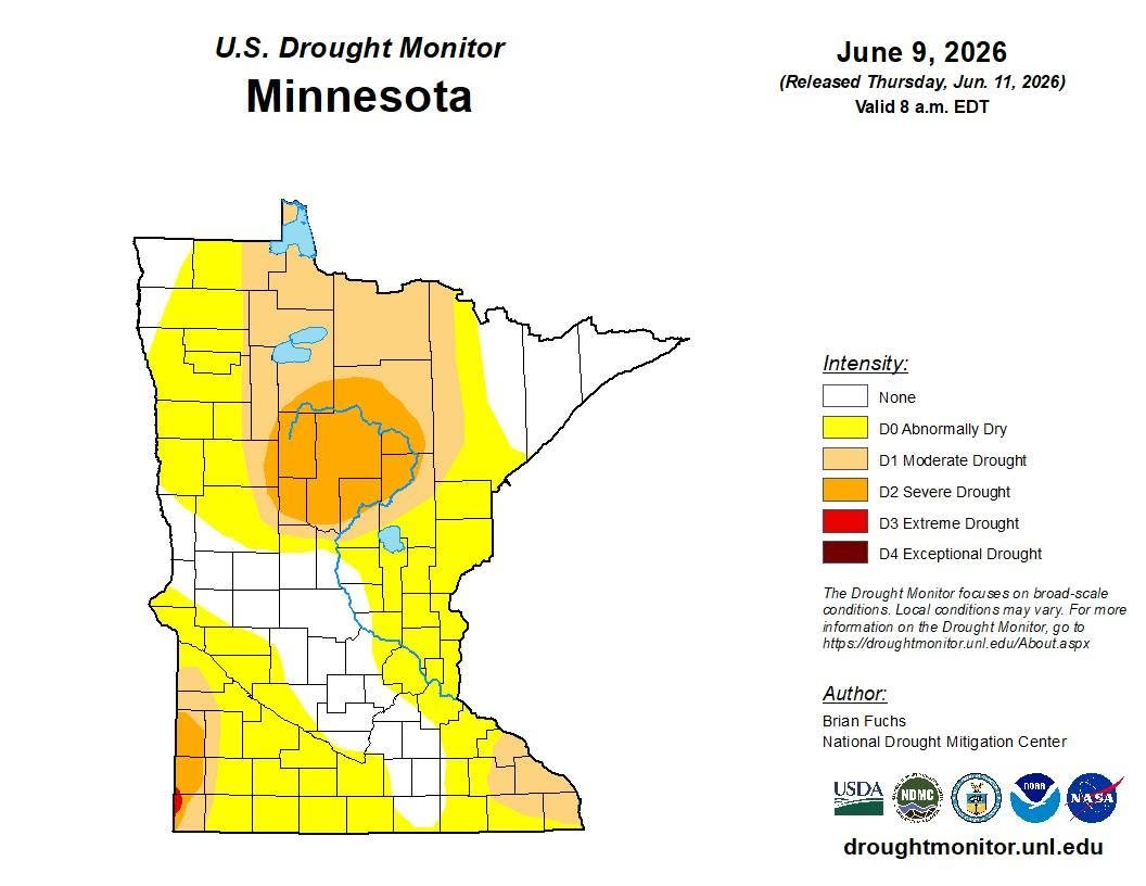
The recent rainfall comes as parts of Minnesota continue to experience varying levels of drought conditions. The latest U.S. Drought Monitor, released June 11 and based on data through June 9, shows portions of central Minnesota remain in Moderate (D1) to Severe (D2) Drought, while areas of eastern and southern Minnesota continue to be classified as Abnormally Dry (D0). While the recent rainfall will help improve soil moisture and reduce stress on lawns, gardens, and agricultural interests, experts note that a single week of rain is unlikely to completely eliminate longer-term precipitation deficits in drought-affected areas.
As previously noted, additional rainfall may arrive this evening as another round of scattered showers and thunderstorms develops along and ahead of a cold front moving through the region. Current forecast guidance suggests that much of the Twin Cities metro could receive an additional 0.05 to 0.18 inches of rain, though locally higher amounts are possible beneath any stronger thunderstorms.
The combination of this week's rainfall and any additional precipitation Friday night should continue the gradual improvement in local moisture conditions, particularly across the Twin Cities metro, where many communities have received close to or more than 1 inch of rain over the past several days.

Cooler Air Arrives for the Weekend
Behind Friday's cold front, a much cooler and drier air mass will move into Minnesota. Saturday will feature noticeably cooler temperatures with highs generally in the middle 70s across the Twin Cities. Areas farther northwest could struggle to reach 70 degrees. Most of the region is expected to remain dry, although a brief isolated shower or thunderstorm cannot be ruled out across far southern Minnesota.
Humidity levels will also remain comfortable, making for a pleasant day for outdoor activities, festivals, sporting events, and yard work.
Sunny and Comfortable Sunday
The pleasant weather pattern continues into Sunday. Mostly sunny skies across the Twin Cities and surrounding areas, with afternoon temperatures reaching the low to mid-70s. Overnight lows will remain cooler than normal for mid-June, providing comfortable sleeping conditions and a break from the summer heat.
Below-Normal Temperatures Continue Next Week
The cooler-than-average pattern is expected to persist through at least the middle of next week. While most of the period looks dry, there is a slight chance of rain returning Monday night into Tuesday. Current probabilities remain relatively low, generally between 10 and 30 percent.
Additional rain chances may return later next week, though confidence remains low regarding timing and coverage.
Forecast at a Glance
Friday
Mostly sunny morning
High near 80°
Scattered afternoon and evening thunderstorms
Isolated storms could produce hail and strong wind gusts
Saturday
Mostly dry and cooler
Highs in the low to mid-70s
Comfortable humidity levels
Sunday
Mostly sunny
Highs in the low to mid-70s
Pleasant outdoor conditions
Next Week
Continued below-normal temperatures
Slight chance of rain Monday night into Tuesday
Additional rain chances possible later in the week