
Twin Cities Area Could See Severe Thunderstorms, Large Hail, Damaging Winds, and Heavy Rain Thursday

Published: June 2, 2026
TWIN CITIES, MINNESOTA: The Twin Cities metro and much of Minnesota could experience strong-to-severe thunderstorms on Thursday, June 4, 2026, as a weather system moving across the Northern Plains creates conditions favorable for large hail, damaging winds, heavy rainfall, and localized flooding.
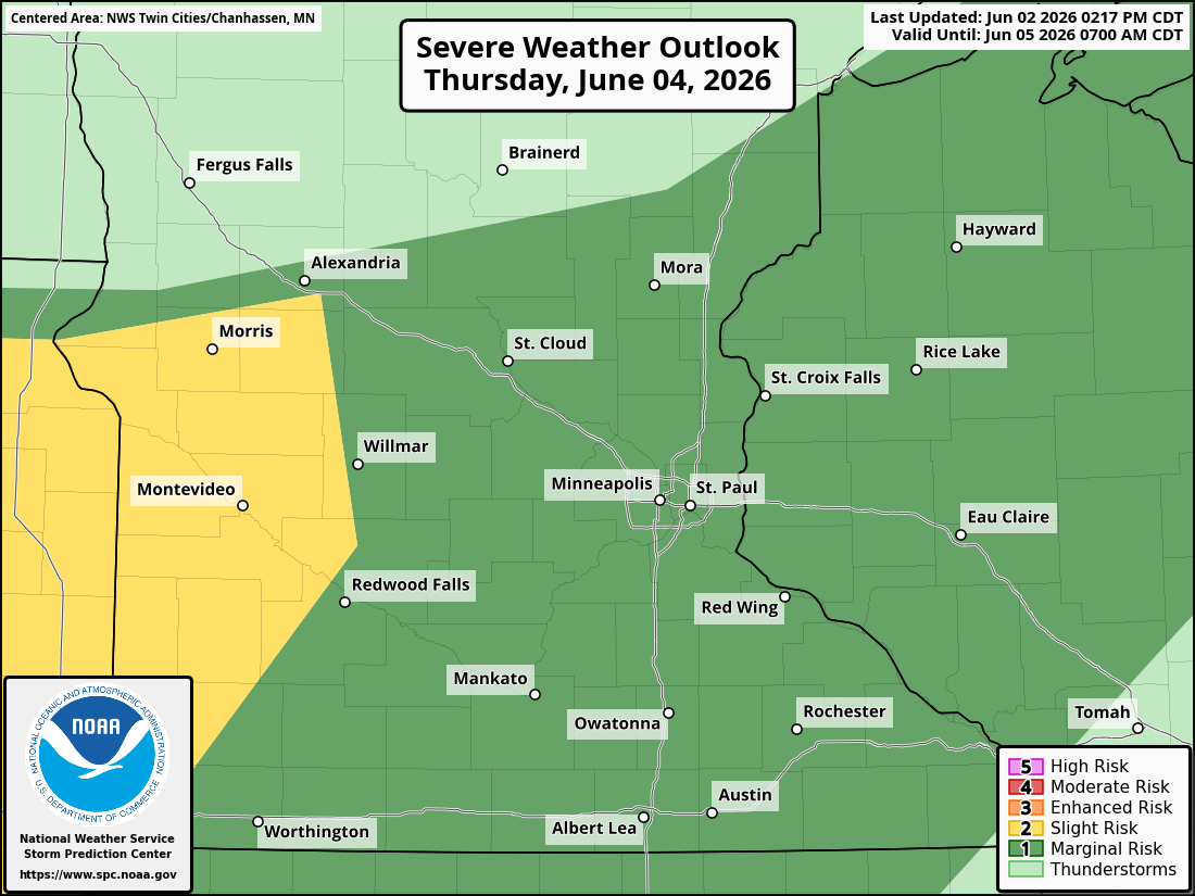
The Storm Prediction Center (SPC) has placed much of Minnesota under a Marginal Risk (Level 1 of 5) for severe weather on both Wednesday evening and Thursday afternoon and evening. While the overall severe weather threat remains relatively low, some storms could become strong enough to produce isolated hazardous conditions.
What You Need to Know
A Marginal Risk (Level 1 of 5) for severe weather exists Wednesday evening across western Minnesota and Thursday afternoon and evening across much of Minnesota and western Wisconsin.
The primary threats on Thursday will be large hail, damaging straight-line winds, and heavy rainfall.
Storm coverage is expected to be more widespread Thursday than Wednesday.
Localized rainfall rates could exceed 1 to 2 inches per hour in the strongest storms.
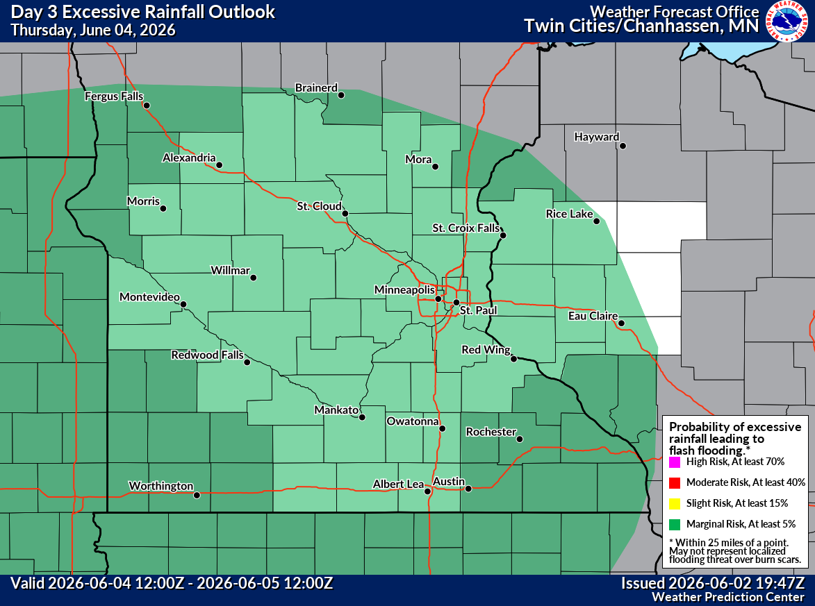
A Marginal Risk (Level 1 of 5) for excessive rainfall has also been issued by the Weather Prediction Center.
Additional thunderstorms are possible Friday, though confidence remains lower regarding timing and location.
Wednesday: Isolated Severe Storms Possible in Western Minnesota
A stationary front currently positioned west of Minnesota will slowly shift eastward over the next 24 hours, allowing warm, summer-like conditions to continue across much of Minnesota and Wisconsin. By Wednesday afternoon and evening, isolated thunderstorms may develop across western Minnesota. Some of these storms could produce hail and damaging winds before weakening as they move eastward overnight.
Wednesday's environment does not appear particularly favorable for widespread severe weather. Atmospheric instability (CAPE) and wind shear are expected to remain modest, limiting the overall severe threat. However, any stronger storms that develop could still produce isolated reports of severe weather.
Thursday: Greater Severe Weather Potential Across Minnesota
The more significant weather concern arrives Thursday as the front becomes better defined across the region and moisture levels increase, when combined with increased instability, steeper lapse rates, and stronger wind shear compared to Wednesday. These ingredients could support stronger thunderstorms that could produce severe weather across a broader area.
While the SPC currently maintains a Marginal Risk (1/5) across the region, portions of Minnesota could eventually be upgraded to a Slight Risk (Level 2 of 5) if confidence in storm development and severity increases.
The greatest severe weather threats on Thursday include:
Large hail
Damaging winds
Frequent lightning
Heavy rainfall, which could result in localized flooding
The exact magnitude of the threat will depend heavily on how much sunshine and heating occur during the afternoon before storms develop, which will help to build instability.
Heavy Rainfall and Flooding Concerns
In addition to severe weather, we will monitor the potential for heavy rainfall as moisture levels are forecast to rise significantly on Thursday, with precipitable water values approaching 1.75 inches, which is well above average for early June. This could allow thunderstorms to become highly efficient rain producers.
Some locations could experience rainfall rates exceeding 1 to 2 inches per hour beneath stronger storms. Additionally, we are monitoring the potential for training thunderstorms.
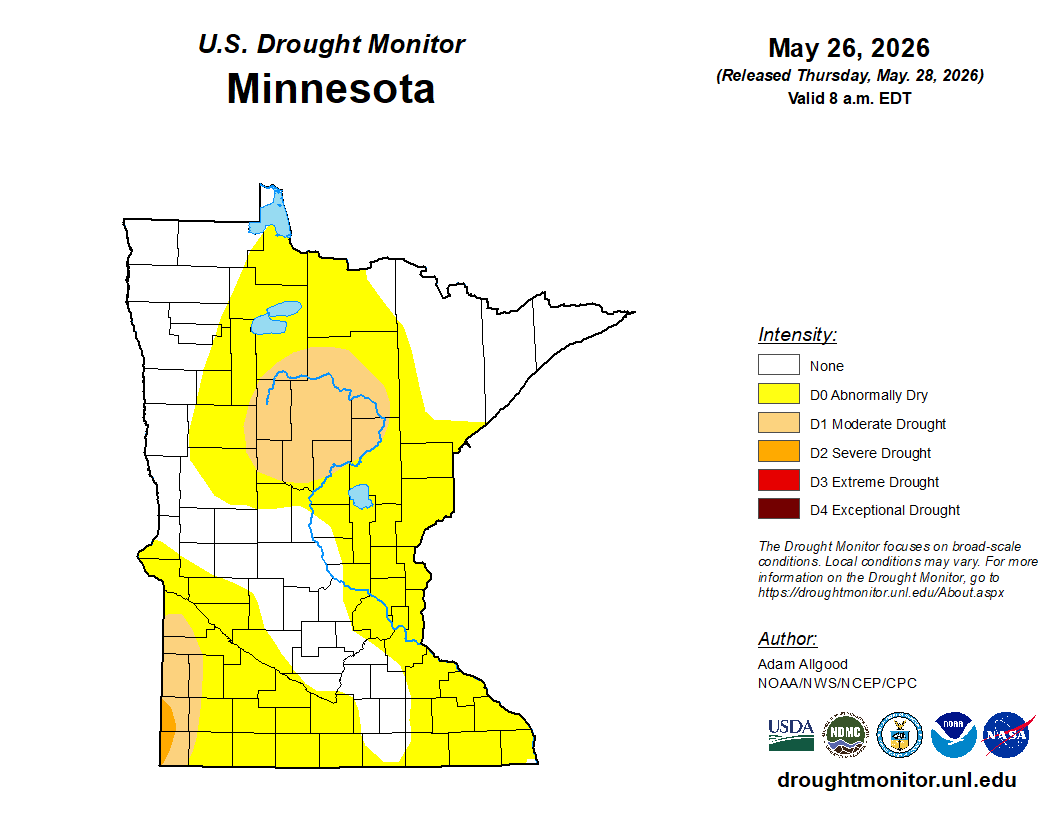
While widespread flooding is not currently anticipated due to relatively dry conditions across much of the region, as much of the Twin Cities Metro is currently under Abnormally Dry conditions according to the U.S. Drought Monitor, localized flooding could occur where storms repeatedly move over the same areas.
The Weather Prediction Center has issued a Marginal Risk (Level 1 of 5) for excessive rainfall across portions of the Northern Plains and Upper Midwest, including Minnesota.
If forecast confidence increases in that scenario, a higher excessive rainfall risk could be issued in later forecast updates.
Friday Forecast Remains Uncertain
The weather pattern is expected to remain active into Friday as the frontal boundary lingers somewhere across southern Minnesota and western Wisconsin.
Current projections suggest the boundary may extend from near Albert Lea to Eau Claire, Wisconsin, though confidence in its exact position remains low.
Additional showers and thunderstorms are expected to develop along the boundary Friday, but uncertainty regarding placement has prevented forecasters from issuing a severe weather outlook at this time.
Future forecasts may introduce additional severe weather risks if confidence improves regarding where the boundary ultimately settles.
Looking Ahead
While Thursday's severe weather threat is not expected to be a major outbreak, conditions could support scattered strong-to-severe storms capable of producing hail, damaging winds, and locally heavy rainfall. Those with outdoor plans Thursday afternoon and evening should have multiple ways to receive weather warnings and be prepared to seek shelter if severe thunderstorms develop.
Forecast details and risk areas will become clearer as Thursday approaches, and additional outlook updates are likely if confidence increases in the severity or coverage of storms.
Stay with Limitless Media News for continuing weather updates and forecast changes as this system approaches Minnesota.
Weather Alerts: None currently in effect for the Twin Cities metro as of Tuesday afternoon, but severe weather outlooks remain in place for Thursday.